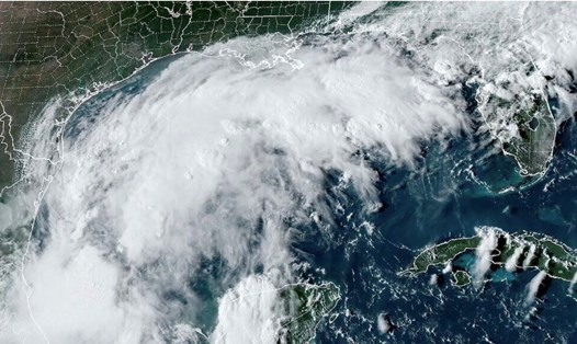
The latest storm information from the US National Hurricane Center (NHC) is that by noon on September 9, storm No. 6 was in the Gulf of Mexico, nearly 300 km south-southeast of the mouth of the Rio Grande, with maximum winds of nearly 100 km/h and stronger gusts.
According to the US National Hurricane Center's hurricane forecast, Hurricane Francine is moving north-northwest at 8 km/h and is expected to move away from the northern Gulf of Mexico coast through September 10, then approach the Louisiana and northern Texas coasts on September 11.
"Francine is forecast to become a hurricane before reaching the northwestern US Gulf Coast on September 11," the NHC's hurricane bulletin stated.

Hurricane warnings are in effect for most of the Louisiana coast from Cameron to Grand Isle.
NHC forecasts that storm No. 6 will bring 100-300 mm of rain and cause flash flooding in northeastern Mexico, southern Texas, southern Louisiana and southern Mississippi until the morning of September 12.
The Washington Post's latest hurricane report says Hurricane Francine formed on the morning of September 9 in the southern Gulf of Mexico. The latest storm in the Atlantic is expected to rapidly intensify as it moves through record-warm waters.
While there may be slight changes to Hurricane Francine's forecast track, computer hurricane models generally predict that the storm will make landfall along the central Louisiana coast, between Lake Charles and Morgan City.
Weather models simulating a range of scenarios for Storm No. 6 show the storm is likely to make landfall with an intensity ranging from a medium-sized tropical storm to a Category 3 hurricane.
The strengthening storm Francine comes amid an unusually quiet period in the Atlantic hurricane season. Francine ends a nearly month-long period without a named storm in the Atlantic at this time of year — the longest since 1968. September 10 marks the peak of the season.

In addition to Hurricane Francine, there are two more Atlantic depressions to watch. One, located between the Lesser Antilles and Cape Verde, has a 60 percent chance of becoming a hurricane. The second, located a few hundred miles southwest of Cape Verde, is expected to gradually strengthen over the next week.
So far, the 2024 Atlantic hurricane season — which began in June and ends on November 30 — has produced five named storms, three of which have strengthened into hurricanes.
The US National Oceanic and Atmospheric Administration is forecasting above-normal storm activity in the Atlantic this year, with 17 to 25 named storms, with 8 to 13 of those becoming hurricanes.
A more intense than normal 2024 hurricane season is forecast due to near-record temperatures in the Atlantic, La Nina in the Pacific, reduced Atlantic trade winds and less wind shear.