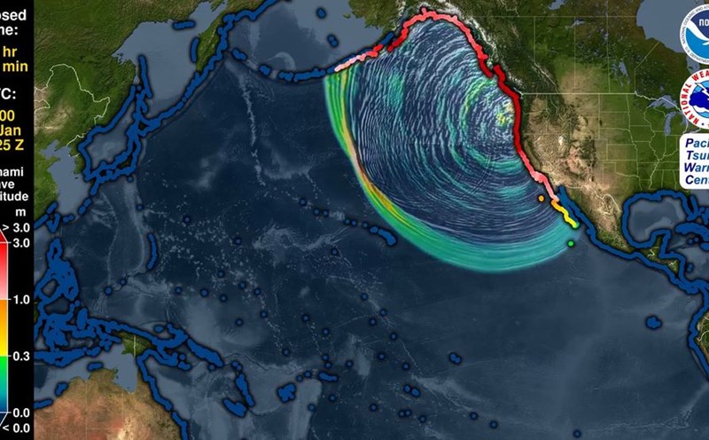
The 6.7 Richter earthquake occurred at 5:03 p.m. (local time) on November 9 off the coast of Iwate Prefecture, northeastern Japan, according to information from the Japan Meteorological Agency (JMA).
The earthquake was recorded as a Category 4 earthquake on the Japanese earthquake scale in Morioka City and Yahaba Town.
Immediately afterwards, the JMA issued a Tsunami warning, predicting that waves up to 1m high could hit the Iwate coast at any time.
NHK reported that some small offshore fluctuations have been observed, and called on people not to stay near coastal areas until the warning is lifted.
According to the US Geological Survey (USGS), the earthquake intensity was measured at 6.8 degrees, while the National Center for Natural Resources and Environment (NCS) recorded it at 6.6 degrees, the center of the earthquake was located at a depth of about 30km, coordinated at 39.51 degrees north latitude, 143.38 degrees east longitude, in the North Pacific Ocean.
Although NHK's live TV images show that the sea is still quite calm, local authorities still recommend that people be ready to evacuate and monitor continuous updates. The authorities also stressed that this is just a warning for prevention, but did not rule out the possibility of unusual waves in low-lying coastal areas.
The earthquake evokes painful memories of 2011, when a 9.0-magnitude richter hit the seabed off the coast of Tohoku, dragging in a 10m-high Tsunami, killing or leaving 18,500 people missing and causing a serious nuclear disaster in Fukushima.
Japan is one of the countries most severely affected by earthquakes and sunslides in the world, located in the "Pacific Ring Road" - the region with the strongest earthquake activity on the planet. Every year, the country records thousands of earthquakes, some of which cause significant damage.