The latest storm information from the Philippine Atmospheric, Geophysical and Astronomical Services Administration (PAGASA) said that at 4:00 a.m. on November 9, the center of typhoon Fung-wong (local name Uwan) was at about 13.8 degrees north latitude, 126.0 degrees east longitude, about 195km east of Virac (Catanduanes).
The storm is moving west-northwest at a speed of 35 km/h, with the strongest wind near the center reaching 175 km/h (level 15), gusting to 215 km/h (above level 17), central pressure 940 hPa.
PAGASA said that the strong to very strong typhoon wind area extends up to 800km from the center of the storm - the range that can cover most of the central and northern Philippines.
The seas around the center of the storm are in an extremely dangerous state, with 14m high waves in Catanduanes, Camarines Sur, Aurora, Isabela and Polillo Islands. The seas east of Cagayan, Albay, Sorsogon and Samar could see waves as high as 12m, while the La Union - Pangasinan sea area could see up to 10m as a danger to all maritime activities.
According to the latest storm forecast, Typhoon Fung-wong is rapidly intensifying and could reach super typhoon level before making landfall in the Aurora area (east of Luzon Island) tonight (November 9) or early tomorrow morning (November 10).
However, the possibility of direct impact or early landfall in Catanduanes has not been ruled out, as the storm may change direction, moving slightly south.
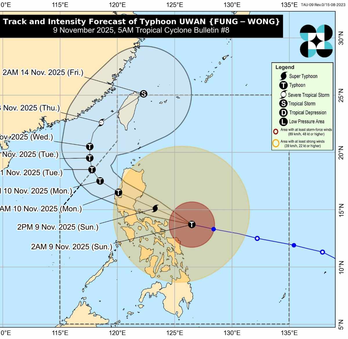
After crossing Luzon, Typhoon Fung-wong is forecast to gradually weaken due to terrain friction, but will still maintain strong typhoon intensity when it enters the Lingayen Gulf or the La Union - Pangasinan sea area on Monday morning (November 10).
From here, many international meteorological models predict that the storm could enter the East Sea, becoming the 14th storm of this year's storm season, moving west-northwest or north-northwest.
After entering the East Sea, forecast centers in Japan and Taiwan (China) have forecast that Typhoon Fung-wong will continue to move north, towards Taiwan (China), with the possibility of making landfall on the west coast of the island around November 12-13.
The China Meteorological Administration (CWA) has planned to issue a sea warning on November 10 and a land warning on November 11.
Meanwhile, the Vietnam National Center for Hydro-Meteorological Forecasting (NCHMF) said that storm No. 14 is unlikely to directly affect the mainland of Vietnam.
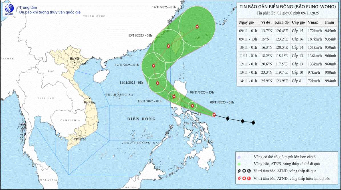
It is forecasted that by 1:00 a.m. on November 11, the center of the storm will be at 18.2 degrees north latitude, 118.1 degrees east longitude, in the sea east of the northern East Sea. The storm intensity will gradually weaken, strong at level 13, gusting to level 16, moving west-northwest, 10-15 km/h.
It is forecasted that by 1:00 a.m. on November 12, the center of the storm will be at 20.6 degrees north latitude, 117.5 degrees east longitude, in the northeastern sea area of the northern East Sea. Strong storm intensity level 13, gust level 16, moving north-northeast, 10-15 km/h.
Due to the influence of the storm, from the next 72-120 hours from 2:00 a.m. on November 9, the sea area east of the northern East Sea will have strong winds of level 6-7, then increase to level 82; the area near the storm center will be strong at level 11-13, gusting to level 16, waves 4.0-6.0m high, then increase to 6.08.0m, the area near the storm center will be 8.0-10.0m. The sea is rough.
During November 10-12, the sea area east of the northern East Sea is likely to be affected by strong winds of level 11-13, gusts of level 16, waves 8.0-10.0m high. The sea is rough.


