The latest storm and low pressure information from the US Navy's Joint Typhoon Warning Center (JTWC) on December 22 said that a new low pressure system that appeared on December 21, named Invest 98W, is operating near Brunei.
This new low pressure in the East Sea is assessed by storm forecasters of the Joint Typhoon Warning Center as having a high possibility of strengthening into an East Sea storm within the next 24 hours.
Currently, low pressure Invest 98W has maximum sustained surface winds of about 35-45 km/h.
Analysis shows that Invest 98W is in a favorable environment for further development, with warm sea surface temperatures (29-30 degrees Celsius).
Current hurricane forecast models generally predict that Invest 98W will move northward over the next 36 hours.
In addition to Invest 98W, the East Sea also has low pressure Invest 99W.
According to the Joint Typhoon Warning Center, this low pressure is currently located in western Luzon, Philippines and has little chance of strengthening into a tropical storm in the next 24 hours.
Low pressure in the East Sea Invest 99W currently has maximum sustained surface winds of about 30 km/h.

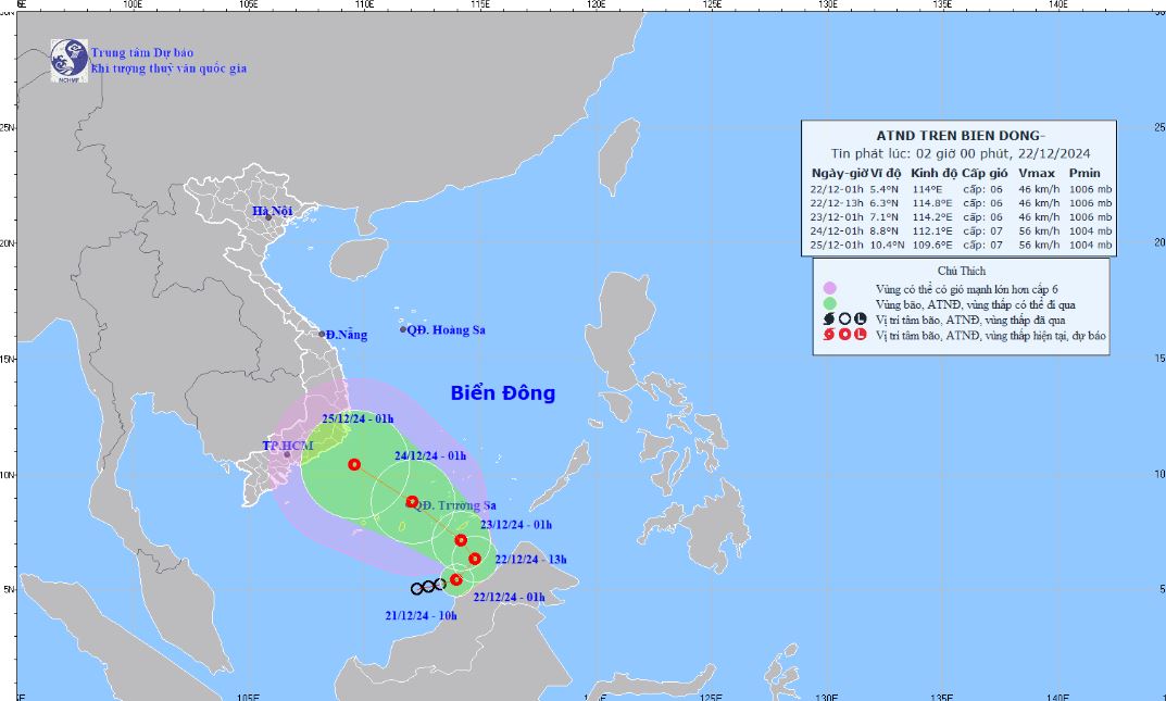
According to the Vietnam National Center for Hydro-Meteorological Forecasting, at 1:00 a.m. on December 22, the center of the tropical depression in the East Sea was at about 5.4 degrees North latitude; 114.0 degrees East longitude, in the southern waters of the southern East Sea area.
The strongest wind near the center of the tropical depression is level 6 (39-49km/h), gusting to level 8; moving east-northeast, speed 5-10km/h.
Vietnam National Center for Hydro-Meteorological Forecasting predicts that in the next 48 to 72 hours, the tropical depression will move northwest at 10-15km per hour.
Regarding the forecast of the impact of the tropical depression, the bulletin stated that the southern sea area of the southern East Sea will have strong winds of level 6, gusts of level 8, waves 3.0-5.0m high; rough seas. From the night of December 22, the southern sea area of Truong Sa archipelago will have strong winds of level 6-7, gusts of level 8-9, waves 4.0-6.0m high; rough seas. Ships operating in the above-mentioned dangerous areas are likely to be affected by storms, whirlwinds, strong winds, and big waves.


