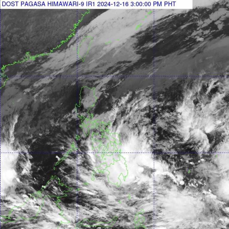
The latest storm and low pressure information from the Philippine weather agency (PAGASA) said that a new low pressure formed within the Philippine forecast area (PAR) at 8:00 a.m. on December 16.
At 2:00 p.m. on December 16, a new low pressure area (LPA 12a) was located in the Philippine PAR forecast area, approximately 230 km east-southeast of Tagum City, Davao del Norte.
PAGASA storm forecasters said the new low pressure has a moderate chance of strengthening into a tropical depression in the next 24 hours.
However, PAGASA noted that the new low pressure will bring rain to many provinces in the Philippines. In particular, from noon on December 16 to noon on December 18, moderate to heavy rain (50-100 mm) is forecast in Dinagat Islands, Surigao del Norte, Surigao del Sur, and Davao Oriental.
From noon on December 18 to noon on December 19, moderate to heavy rains (50-100 mm) are forecast in Dinagat Islands, Surigao del Norte. "Localized flooding may occur in urbanized areas, low-lying areas or near rivers," PAGASA said in its forecast. Landslides are especially likely in high-risk areas.
Weather in other areas in Mindanao as well as Eastern Visayas and Central Visayas is likely to be affected by the Intertropical Convergence Zone (ITCZ) leading to scattered rains and thunderstorms.
Meanwhile, wind shear will bring scattered rains and thunderstorms to Bicol, Quezon, Marinduque and Oriental Mindoro on December 16. Wind shear is a point where cold air from the northeast monsoon converges with easterly winds (or warm winds) from the Pacific Ocean.
The northeast monsoon is affecting Cagayan Valley, Cordillera and Aurora regions causing rain on December 16.
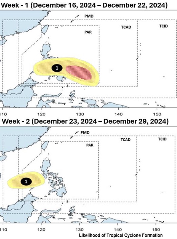
According to the latest storm forecast by PAGASA released at noon on December 16, during the week from December 16 to 22, the low pressure area is likely to strengthen into a tropical storm in the PAR forecast area. Philippine storm forecasters assess the possibility of the low pressure area strengthening into a storm during the forecast period as medium to high.
Notably, storm forecasters warn that the low pressure system is likely to strengthen into a new storm near the Philippines and is expected to sweep across the Philippines during the week of December 16-22 and enter the East Sea.
The latest storm is forecast to enter the East Sea during the week from December 23 to December 29, becoming storm number 10.
Once it strengthens into a typhoon within the Philippine PAR forecast area, the storm will be named Querubin. It is expected to be the 17th storm to impact the Philippines this season.
In its December typhoon forecast, PAGASA forecasts one to two tropical storms to form within the PAR forecast area or enter the PAR during the month. The most recent storm to impact the Philippines this season was Super Typhoon Pepito (international name: Man-yi) in mid-November.