Floodwaters rose unpredictably, in just a few hours, small, deep alleys in Da Nang City turned into rivers, but people here considered floods to be a part of their lives: "Fortunately, the floodwaters this year did not rise as high as last year".
Unexpected flood
The first week when I traveled from Hanoi to the Central region Representative Office, I was enthusiastically instructed by my colleagues: "Although I have been here for 6 months, I will experience the extremely memorable storms and floods". I was half-expected, half-real, until I experienced a flood that did not stop, just a few hours of prolonged rain could cause all roads in the city to be flooded, vehicles stalled along the road.
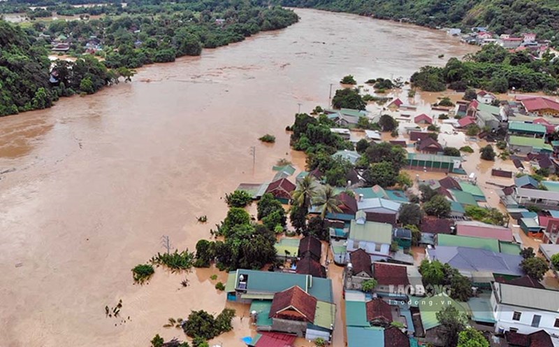
Da Nang - the city is surrounded by hills and winding rivers such as Han, Co Co, Cu De, Vinh Dien... but during the rainy season, the flood water still rises very quickly and cannot escape in time. One of the places where floodwaters will pour in the most is in Me Suot residential area. The flood in June 2025 caused the entire area to be deeply flooded, people had to stay up all night to find a way to move the elderly, children, belongings such as motorbikes, electronics... onto life buoys to safety.
Even that night, no one dared to sleep in the entire residential area because they were afraid that the flood water would rise quickly, flood into their homes, and cause widespread flooding.Talking about the memories of floods, there are households on Me Suot Street that clearly remember every trace of rising floodwaters or historic flood flights, there were years when water flooded into their homes, the whole family sat in groups on a bucket watching all their belongings submerged in water because they could not be moved: "The rain was still there, a few years ago the floodwaters were still inundated with ancestral altars".
In the Central region, especially in deep alleys, where the road surface is higher than the floor, low-rise attics have become a place to store belongings, a "lifeline" for the whole family.Not called a floor, it cannot be a complete room, the attic is patched with wood, corrugated iron or board tightly to the roof, above the kitchen or bedroom has become a "style" typical of many people here to apply, dealing with the immense water when floods come.
Not only flooding in the inner city, coastal people of Da Nang, especially fishermen who fish for the net, also have to live in a "storm-fighting" mentality. Every rainy and stormy season, the atmosphere in coastal fishing villages such as Man Thai and Tho Quang also appreciates each weather forecast.
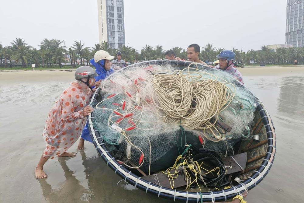
The entire fishing village mobilized forces early in the morning to tie up, pull the boat to shore, and anchor each net and basket boat before the storm made landfall. For the people here, floods are not a natural phenomenon but a repetitive challenge - they have to face it as an inevitable part of life.
City struggles to prevent flooding in the middle of summer
In recent years, Da Nang City has been facing the impacts of complex climate change, especially the appearance of extreme rain. Notably, floods from the beginning of 2025 to now have revealed many shortcomings in the city's drainage system.
According to statistics from the Da Nang Department of Construction, the whole city has 124 locations at risk of flooding when there is heavy and extreme rain, the most of which are Thanh Khe district (41 locations), Lien Chieu (29 locations), Cam Le (18 locations)... Of which, there are 10 locations and key areas that are flooded during the period of heavy rain such as the area around Thac Gian - Vinh Trung lake; Hai Ho street area; the area of 640 Trung Nu Vuong; Phong Bac canal area; Me Suot street area; Nui Thanh street area; Le Tan Trung street area; Hoa Khanh Industrial Park gate area; the downstream area of Kan Can culvert and the Yen Bac - Yen Son canal area.
The Management Board of Da Nang City Priority Land Use Infrastructure Investment Projects (PMU) previously announced the public consultation on the project to adjust the urban elevation and surface drainage planning to 2030, with a vision to 2045. This project is expected to be a key solution to the flooding problem affecting many areas in the city.

According to the project's analysis, the rapid urbanization process along the Vu Gia - Thu Bon river basin and Cu De river has significantly changed the current situation of elevation in Da Nang. Many urban areas such as Hoa Xuan - Cam Le, urban areas along the Co Co River, high-tech parks, Golden Hills and Thuy Tu are all affected.
The construction of major traffic routes such as ADB road, National Highway 14, Da Nang - Quang Ngai Expressway and Hoa Phuoc - Hoa Khuong road has unintentionally created "dyks" blocking the flow, changing the distribution of floods and increasing flooding on these routes as well as in front of urban areas along both banks of Cam Le river.
Mr. Nguyen Cuu Loan - Vice Chairman of the Urban Planning and Development Association of Da Nang City - said that recently, the frequency of heavy rains has increased, exceeding the capacity of the existing drainage system. The city's drainage system still has many shortcomings, especially in the city center area that was built a long time ago and is now degraded; some local points have unreasonable drainage and elevation.
The current status of underground technical infrastructure still has many shortcomings and overlaps such as power supply, water supply, fiber optic cables installed running through water intake gates, manholes, and gates, reducing drainage capacity. Not only that, according to experts, suburban areas have illegal house construction, not planned properly, technical infrastructure has not been invested synchronously, some areas do not have drainage systems and have low terrain.
In addition to climate change, hydropower plants release water at the source, prolonged heavy rain, high tides, along with the rapid concrete conversion are also one of the causes of widespread flooding in Da Nang.