Tropical depression approaches land causing widespread rain

Chí Long |

The tropical depression is forecast to approach the Philippine mainland, preparing to head towards the East Sea.

According to the latest storm self-report from the Philippine Atmospheric, Geophysical and Astronomical Services Administration, this morning, December 5, the tropical depression is approaching the mainland of the Central region of this country.

As of 7:00 a.m. (local time), the center of the tropical depression was at about 11.6 degrees North latitude - 127.6 degrees East longitude, 235 km east of Borongan City, Eastern Samar. The strongest wind near the center of the tropical depression reached 45 km/h, gusting to 55 km/h.

Cap nhat vi tri cua ap thap nhiet doi gan Bien Dong. Anh: PAGASA
Updated location of the tropical depression near the East Sea. Photo: PAGASA

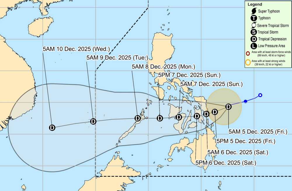
The tropical depression is moving southwest at a speed of 15 km/h. Strong winds extend outwards the center up to 220 km.

Due to the influence of the tropical depression, heavy rain appeared in many areas of the mainland. Accordingly, the rainfall was 100-200mm in Northern Samar, Eastern Samar, Samar, Biliran, Leyte, Southern Leyte, Catanduanes, Albay, Sorsogon and Masbate.

Rainfall of 50-100mm in the Philippines, Bohol, Negros Oriental, Negros Occidental, Siquijor, Guimaras, Iloilo, Capiz, Surigao del Norte, Dinagat Islands, Agusan del Norte, Misamis Oriental, Camiguin, Lanao del Norte.

The low pressure is forecast to cross the Philippine mainland and enter the East Sea early next week.

In the East Sea, according to the National Center for Hydro-Meteorological Forecasting, the North East Sea area (including Hoang Sa special zone): Northeast winds of level 6, sometimes level 7, gusting to level 8-9. Strong seas. Waves are 3.0-5.0m high.

Gulf of Tonkin, the sea area from South Quang Tri to Quang Ngai and the western sea area of the South China Sea (including the western sea area of Truong Sa special zone): Northeast winds of level 5, sometimes level 6, gusting to level 7. Rough seas. Waves are 2.0-4.0m high, with the Gulf of Tonkin alone being 1.5-2.5m.

Central East Sea area: Northeast wind level 6, gust level 7-8. Rough seas. Waves are 3.0-5.0m high. The sea area from Khanh Hoa to Ca Mau: the Northeast wind gradually strengthens to level 6, gusting to level 7-8. Rough seas. Waves are 2.0-4.0m high.

The sea area from South Quang Tri to Quang Ngai, the South East Sea area (including Truong Sa special zone) and the Gulf of Thailand will have scattered showers and thunderstorms.

People and tourists should be on guard during thunderstorms with the possibility of tornadoes and strong gusts of wind of level 6-7. Tourists coming to the Philippines should regularly check their flight schedules and follow local instructions to ensure safety.

Chí Long
TIN LIÊN QUAN

Tropical depression causes heavy rain and wind, enters the East Sea next week

|

According to the latest tropical depression forecast, the tropical depression near the East Sea will continue to maintain its intensity and move slowly.

The first area of landfall of the tropical depression is likely to become storm No. 16

|

According to the latest low pressure forecast, a tropical depression is about to make landfall in the Philippines and is likely to enter the East Sea around December 8, possibly becoming storm No. 16.

Forecast of the time when the tropical depression will make landfall in the East Sea

|

The tropical depression will form near the East Sea, forecast to enter the East Sea next week.

New tropical depression near the East Sea officially revealed, heavy thunderstorms

|

Tropical depression Wilma formed near the East Sea, becoming the focus of the latest typhoon forecasts in the Philippines.

Forecast of the possibility of a tropical depression near the East Sea becoming storm Wilma

|

The low pressure area that is active east of the Philippines is forecast to become a new storm.

Tropical depression causes heavy rain and wind, enters the East Sea next week

Ninh Phương |

According to the latest tropical depression forecast, the tropical depression near the East Sea will continue to maintain its intensity and move slowly.

The first area of landfall of the tropical depression is likely to become storm No. 16

Ninh Phương |

According to the latest low pressure forecast, a tropical depression is about to make landfall in the Philippines and is likely to enter the East Sea around December 8, possibly becoming storm No. 16.

Forecast of the time when the tropical depression will make landfall in the East Sea

Chí Long |

The tropical depression will form near the East Sea, forecast to enter the East Sea next week.

New tropical depression near the East Sea officially revealed, heavy thunderstorms

Ninh Phương |

Tropical depression Wilma formed near the East Sea, becoming the focus of the latest typhoon forecasts in the Philippines.

Forecast of the possibility of a tropical depression near the East Sea becoming storm Wilma

Ninh Phương |

The low pressure area that is active east of the Philippines is forecast to become a new storm.