Storm Podul intensifies violently, tropical depression in the East Sea weakens

Chí Long |

The tropical depression is forecast to weaken in the East Sea, while Typhoon Podul is strengthening with winds reaching 85km/h.

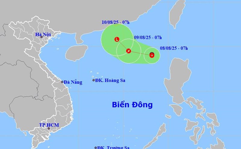
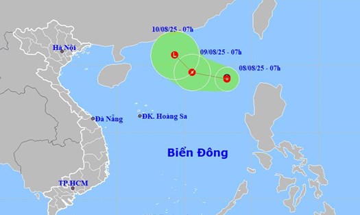
According to new weather news from the National Center for Hydro-Meteorological Forecasting, at 7:00 p.m. on August 8, the center of the tropical depression was at about 18.8 degrees North latitude - 117.8 degrees East longitude, in the eastern sea of the North East Sea.

The strongest wind near the center of the tropical depression is level 6 (39-49km/h), gusting to level 8. The tropical depression moved slowly to the West, at a speed of about 5km/h.

Cap nhat vi tri cua ap thap nhiet doi tren Bien Dong. Anh: Trung tam Du bao Khi tuong Thuy van quoc gia
Updated location of the tropical depression in the East Sea. Photo: National Center for Hydro-Meteorological Forecasting

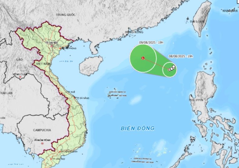
It is forecasted that by 7:00 p.m. on August 9, the tropical depression will move in the West Northwest direction at a speed of 10-15km/h and gradually weaken into a low pressure area. The center of the low pressure is located at about 19.9 degrees North latitude - 115.1 degrees East longitude, about 490km northeast of Hoang Sa archipelago.

The strongest wind near the center of the low pressure is less than level 6. Natural disaster risk level: level 3 for the eastern sea area of the North East Sea.

Due to the influence of the tropical depression, the eastern sea area of the North East Sea will have thunderstorms and strong winds of level 6, gusts of level 8, waves 2.0-3.0m high, rough seas.

Ship operating in the above-mentioned dangerous area are likely to be affected by thunderstorms, whirlwinds, strong winds, and large waves.

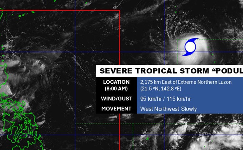
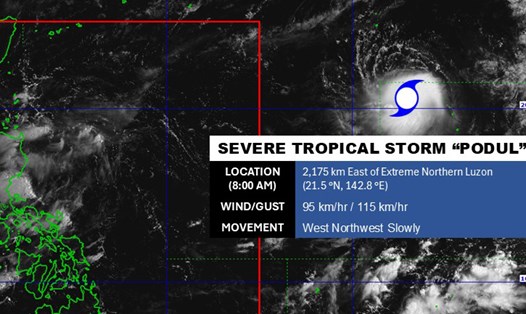
Meanwhile, tropical storm Podul is still active near the East Sea.

According to the Philippine Atmospheric, Geophysical and Astronomical Services Administration (PAGASA), at around 8:00 p.m. on August 8 (local time), the center of the storm was located at about 20.9 degrees North latitude - 144.3 degrees East longitude, about 2,335km east of Luzon's northernmost tip.

Cap nhat huong di cua bao Podul tren bien. Anh: PAGASA
Update the path of Typhoon Podul at sea. Photo: PAGASA

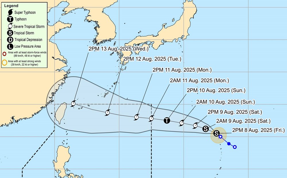
The strongest wind near the center of the storm reached 85km/h, gusting to 105km/h. The storm is moving west-northwest towards the mainland of Taiwan (China) and is forecast to continue to strengthen into a severe tropical storm on the evening of August 9.

People and tourists planning to travel to the Gulf of Tonkin, the Philippines, Taiwan (China) or eastern provinces of China should pay attention to weather forecasts. Tuan followed the local instructions and checked the schedule and information from the airline and the transport unit.

Chí Long
TIN LIÊN QUAN

Storm Podul rapidly strengthens in the next 48 hours, maximum winds of up to 140km/h

|

Typhoon Podul is moving very quickly in the Pacific Ocean, forecast to strengthen in the next 48 hours. While the tropical depression caused rain in the East Sea.

Tropical depression officially forms in the East Sea

|

The low pressure in the East Sea has strengthened into a tropical depression.

New low pressure enters the East Sea, widespread thunderstorms

|

A low pressure has an average probability of developing into a tropical depression in the next 24 hours in the East Sea.

Tropical depression will strengthen into lightning in the next 24 hours

|

The tropical depression is forecast to strengthen over the next 24 hours in the northwest Pacific Ocean.

Tropical depression becomes storm Henriette, likely to continue to strengthen

|

According to new storm news from the US National Hurricane Center (NHC), the tropical depression has strengthened into tropical storm Henriette in the eastern sea of the Pacific Ocean.

Storm Podul rapidly strengthens in the next 48 hours, maximum winds of up to 140km/h

Ninh Phương |

Typhoon Podul is moving very quickly in the Pacific Ocean, forecast to strengthen in the next 48 hours. While the tropical depression caused rain in the East Sea.

Tropical depression officially forms in the East Sea

Chí Long |

The low pressure in the East Sea has strengthened into a tropical depression.

New low pressure enters the East Sea, widespread thunderstorms

Ninh Phương |

A low pressure has an average probability of developing into a tropical depression in the next 24 hours in the East Sea.

Tropical depression will strengthen into lightning in the next 24 hours

Ninh Phương |

The tropical depression is forecast to strengthen over the next 24 hours in the northwest Pacific Ocean.

Tropical depression becomes storm Henriette, likely to continue to strengthen

Ninh Phương |

According to new storm news from the US National Hurricane Center (NHC), the tropical depression has strengthened into tropical storm Henriette in the eastern sea of the Pacific Ocean.