Forecast of the possibility of a new low pressure near the East Sea strengthening into a storm

Ninh Phương |

The low pressure near the East Sea is likely to strengthen into a tropical depression, not excluding the possibility of becoming a storm in the next two weeks.

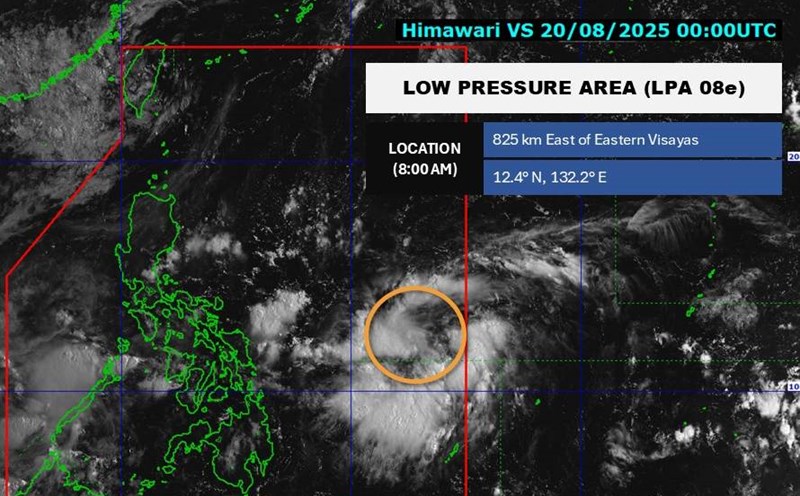
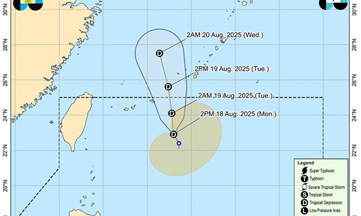
According to the new low pressure forecast from the Philippine Atmospheric, Geophysical and Astronomical Services Administration (PAGASA), the low pressure is at about 13.5 degrees North latitude - 130.9 degrees East longitude on the night of August 20. The low pressure is more than 700km east of the Catanduannes of the Philippines.

The possibility of the low pressure strengthening into a tropical depression is at a moderate level.

Meanwhile, the Joint Typhoon Warning Center (JTWC) recorded the maximum sustained wind speed of the depression at about 35-45 km/h. Environmental analysis shows generally favorable conditions for the low pressure to continue to develop.

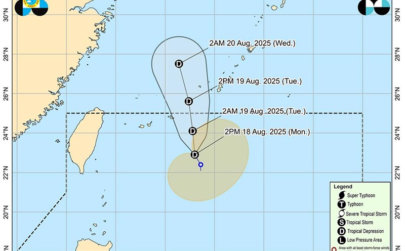
Forecast models are not yet unified in the intensity of the low pressure, but all predict that the low pressure will tend to move northwest, towards Luzon (Philippines) in the coming days.

PAGASA also issued a tropical depression forecast bulletin for the period August 20 to September 2, 2025.

In the week of August 20 to 26, 2025, this low pressure is forecast to move through the Northern Luzon area with the possibility of developing into a low to moderate storm.

By the week of August 27 - September 2, the low pressure is likely to continue moving towards the Vietnam - Hainan Island (China). A new low pressure may appear at the eastern edge of the Philippine Area of Responsibility (PAR) during this time, but the possibility of developing into a storm is underestimated.

People and tourists, especially in the Northern Luzon area (Philippines), Hainan Island (China) and coastal provinces of Northern Vietnam, need to closely monitor official weather forecasts.

Tourists planning to participate in outdoor activities, sea tourism or travel by water should consider the plan and follow the instructions of the authorities to ensure safety.

Ninh Phương
TIN LIÊN QUAN

Storm Erin threatens the mainland with winds of 160km/h, dozens swept away

|

Erin is not expected to make landfall, but the affected area is very large, causing dangerous high waves and offshore flows on many beaches in the US.

New low pressure near the East Sea is likely to strengthen

|

A new low pressure is forecast to appear near the East Sea and is likely to strengthen in the next 24 hours.

Tropical depression near the East Sea accelerates, gusts of over 70 km/h

|

While the tropical depression on the mainland of Vietnam is weakening, another tropical depression is strengthening near the East Sea.

Tropical depression Huaning near the East Sea continues to strengthen

|

While the tropical depression is gathering in the Gulf of Tonkin, tropical depression Huaning is continuing to strengthen.

Storm Erin threatens the mainland with winds of 160km/h, dozens swept away

Ninh Phương |

Erin is not expected to make landfall, but the affected area is very large, causing dangerous high waves and offshore flows on many beaches in the US.

New low pressure near the East Sea is likely to strengthen

Chí Long |

A new low pressure is forecast to appear near the East Sea and is likely to strengthen in the next 24 hours.

Tropical depression near the East Sea accelerates, gusts of over 70 km/h

Chí Long |

While the tropical depression on the mainland of Vietnam is weakening, another tropical depression is strengthening near the East Sea.

Tropical depression Huaning near the East Sea continues to strengthen

Ninh Phương |

While the tropical depression is gathering in the Gulf of Tonkin, tropical depression Huaning is continuing to strengthen.