TRIP
A Pa Chai, the westernmost point of the country, is the border junction of three countries: Vietnam, China, and Laos. That is why people say that here, when a rooster crows, people from three countries can hear it.
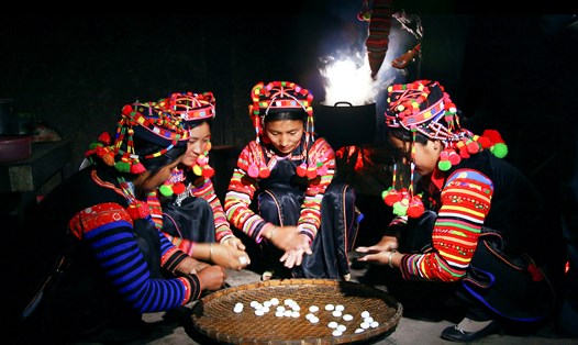
This metaphor is both correct and confusing for people with Bo Y border gate of Kon Tum province, which is called “Indochina Junction”, which is the border intersection of Vietnam, Laos, and Cambodia. And this place also has a metaphor about a crowing rooster like in A Pa Chai, and also has a delicious dish of chicken cooked with giang leaves.
But anyway, the place name Bo Y will be mentioned in another article, this time, we come to the chicken in the far West. A Pa Chai is the name of a small village in Sin Thau commune, Muong Nhe district, Dien Bien province. A Pa Chai in Ha Nhi language means a flat, vast land.
However, the westernmost landmark is not located on a flat place at all. This unique three-sided border landmark is located on the top of Khoang La San, in Sin Thau commune, about 250km from Dien Bien Phu city. A Pa Chai is located at an altitude of 1866.23m, coordinates 22°24'02.295" north latitude, 102°08'38.109" east longitude.
Getting here was not easy. We took a sleeper bus from Hanoi at 7pm, swaying and swaying like a hammock for the entire 450km journey, arriving in Dien Bien Phu city at 5am. Without having time to eat breakfast, we hurriedly jumped on the only bus running to Muong Nhe that day.
So we wobbled another 200km, but this time it took a full 12 hours with pigs and chickens squealing above and below to reach the center of Muong Nhe district - a notorious place that once wasted the ink of our journalistic colleagues working in the field of national security and defense.
It was late afternoon but the destination was not yet reached. Had to rent a motorbike to go from Muong Nhe to A Pa Chai, another 65km. The consequences of the flood had also devastated Muong Nhe. The wounds of the mountains and forests were torn open, turning red with blood. The road from Muong Nhe to A Pa Chai took nearly 5 hours to travel because of landslides.
Travel conditions were very difficult, from the center of Dien Bien province to A Pa Chai, approximately 250km, the only way was to walk, and it would take a healthy person 10 days. But then, we finally arrived at A Pa Chai. The late afternoon light suddenly lit up brightly to welcome the group of strangers. We only had time to look around a bit, then quickly walked to find the way to the accommodation before it got dark, which Google Map only called for fun.
It was a large house of a merchant woman who came here to make a living, selling groceries to the locals, providing accommodation for backpackers from the lowlands, and also a temporary residence and absence registration point for the border post. It had to be like that, because this place was full of signs saying “Border Area”.
And then, we were able to brush our teeth, wash our faces, and take a shower after nearly 24 hours. Dinner took place amidst the sound of rain pounding on the tin roof, making everyone feel uneasy. When trekking in the mountains and forests, the most feared thing is rain, because then the difficulty increases many times over.
A CUP OF TEA ON THE TOP OF KHOA LA SAN
That night, and the next morning, it rained so hard that the ground was rotten, but we still decided to climb to the top of Khoang La San, the westernmost point of A Pa Chai, full of pride and challenge. It rained all night and the next morning, and only stopped around 11 o'clock, just like the saying: "The rain never goes past Ngo, the wind never goes past Mui".
We, the daredevils, decided to conquer the pristine westernmost point before it became touristy. We stopped at the A Pa Chai border post and asked Chu Van Le, the head of the border post at that time, to send a soldier to guide our group up to the landmark.
At that time, A Pa Chai did not have a fixed route to the landmark, but only a border patrol trail, so we had to rely on border guards to guide us for peace of mind. Stopping at the foot of Khoang La San mountain, we went to the cliff, lowered a rope to climb up the trail.
From here, we followed a narrow path, just wide enough for one person to walk, muddy below, and water-laden branches whipping our faces above. The space was dark and damp, with occasional dead ends opened by the locals. Without the young soldier guiding us, we could easily get lost. The path kept going uphill, uphill to the point of breathlessness.
The journey to the westernmost point of A Pa Chai is clearly a personal challenge, but it is also a journey to the sky. There is no going down, no going sideways, only going up, which means there is no room for discouragement and doubt. Just keep going, keep your heart strong and keep your hope throughout this 3km journey.
Then, after nearly 2 hours of going uphill, the westernmost point of A Pa Chai appeared at an altitude of 1,864 meters above sea level on the top of Khoang La San mountain. A paradise suddenly opened before the traveler's eyes. A jade-blue sky poured a golden light that enveloped the whole body and mind.
On the top of Khoang La San mountain, the sky is so close that you can reach it with your hand. The white clouds like torn silk flutter under your feet, creating an illusion of wandering. Here, people think they have escaped their human form and become immortals, standing in one place and seeing the mountains and forests of Yunnan province (China), Phong Xa Ly province (Laos), and even Muong Nhe (Dien Bien), Muong Te (Lai Chau).
A flat marble base, in the middle stands a three-sided border marker, each side inscribed with a geographical text in one of three languages: Vietnamese, Chinese, Lao. The marker was jointly built by the three countries, made of marble placed on a 6x6m square base, each side has the national emblem of each country, started on April 21, 2005 and completed on May 27, 2005.
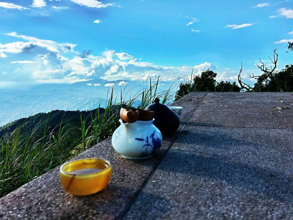
After a few minutes of rest to regain our strength, we let the Ha Nhi border guard lie comfortably under the warm afternoon sun. We opened our backpacks, took out the thermos, teapot, and teacups, and brewed tea. The fragrant aroma of ripe Pu'er tea wafted up. Coincidentally, on the other side of the border was the Pu'er tea growing region of Yunnan province.
We sat on the marble platform, holding teacups, admiring the warm reddish-brown color of the tea, smelling the scent of honey and ripe wild fruits in the tea, slowly enjoying the leisurely atmosphere. At that moment, white clouds rushed in from somewhere, meeting the afternoon sunlight, suddenly turning a magical pink, enveloping the group of red-robed travelers enjoying tea in the middle of a fairyland.
It was a rare experience in life, to enjoy tea in the afternoon of clouds and mountain wind on the westernmost peak.It is not often that one can encounter such a scene, because the river water of today is no longer the water of yesterday.
I lay on the granite wall, letting the late afternoon sunlight bite my face.Looking up at the drifting clouds and blowing wind, I just wished that I could hear a rooster cry, from anywhere, but if it was a Vietnamese rooster cry, it would be wonderful.Because that is the rooster cry of the homeland, of the country in this remote area!