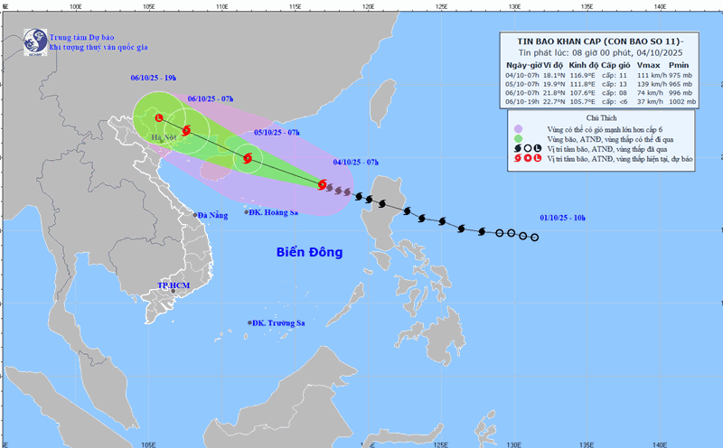
Updated from the National Center for Hydro-Meteorological Forecasting, at 7:00 p.m. on October 4, the center of the storm was at about 18.7 degrees north latitude; 114.3 degrees east longitude, in the northern East Sea, about 380 km east-southeast of Hainan Island (China). The strongest wind near the storm center is level 12 (118-133 km/h), gusting to level 15. The storm is moving west-northwest at a speed of about 25 km/h.
Storm makes landfall in Quang Ninh with an intensity of about level 8-9
It is forecasted that in the next 12 hours, the storm will move west-northwest at a speed of 20-25 km/h and is likely to strengthen.
At 7:00 a.m. on October 5, the center of the storm was at about 19.8 degrees north latitude; 111.9 degrees east longitude, in the northwestern sea of the northern East Sea, about 500 km east-southeast of Quang Ninh. Strong wind level 12-13, gust level 16.
The danger zone is north of latitude 17 degrees north; east of longitude 110-116.5 degrees east. The natural disaster risk level is level 3 for the northwestern sea area of the northern East Sea and the eastern sea area of the northern Gulf of Tonkin.
According to Mr. Nguyen Van Huong - Head of Weather Forecasting Department, National Center for Hydro-Meteorological Forecasting, when crossing the northern part of the Lusian Peninsula (China) and entering the Gulf of Tonkin, the storm will rub against the ground and the wind shear in this area will increase, so the storm intensity tends to decrease gradually.

It is forecasted that in the next 24 hours, the storm will continue to move west-northwest at a speed of 20-25 km/h. At 7:00 p.m. on October 5, the center of the storm was at about 20.9 degrees north latitude; 109.4 degrees east longitude, in the sea east of the northern part of the Gulf of Tonkin, about 190 km southeast of Quang Ninh. Strong wind level 11-12, gust level 15.
The danger zone is 17.5 degrees north latitude north of the line; 108-113.5 degrees east longitude east of the line. The natural disaster risk level is level 3 for the northwestern sea area of the northern East Sea and the northern area of the Gulf of Tonkin.
It is forecasted that in the next 36 hours, the storm will move west-northwest at a speed of about 20 km/h. Around the morning of October 6, the storm may make landfall.
"Our calculation on the path of the storm shows that in the coming time, the storm will shift north, the storm will enter the area between Quang Ninh (Vietnam) and Guangxi province (China)" - Mr. Huong said.
At 7:00 a.m. on October 6, the center of the storm was at about 21.8 degrees north latitude; 107.5 degrees east longitude, in the area between Quang Ninh province (Vietnam) and Guangxi province (China). Strong wind level 8-9, gust level 12.
The danger zone is north of latitude 19 degrees north; west of longitude 112 degrees east. Level 3 natural disaster risk for the northern sea area of the Gulf of Tonkin and the coastal mainland area from Quang Ninh to Hung Yen.
It is forecasted that in the next 48 hours, the storm will move west-northwest at a speed of about 20 km/h, moving deep into the mainland and gradually weakening into a low pressure area. At 7:00 p.m. on October 6, the center of the low pressure area was at about 22.3 degrees north latitude; 105.6 degrees east longitude, in the northern mountainous area of the North. Wind intensity below level 6.
Need to be on guard against the risk of thunderstorms before the storm makes landfall
Regarding the impact of the storm at sea, the northern East Sea area has strong winds of level 8-10, the area near the storm center has level 11-13, gusts of level 15-16; waves 4-6 m high, the area near the storm center has 6-8 m, the sea is rough, has extremely large destructive power, the sea waves are extremely strong and can sink large heavy ships.
From the afternoon of October 5, the sea area east of the northern part of the Gulf of Tonkin (including the Bach Long Vi special zone) will have winds gradually increasing to level 6-7, then increasing to level 8-9. From the evening of October 5, the northern area of the Gulf of Tonkin (including the special areas of Bach Long Vi, Van Don, Co To, Cat Hai and Hon Dau island) will gradually increase to level 8-9, waves 2-4 m high; the area near the storm's eye will have level 10-11, gusts of level 14, waves 3-5 m high, rough seas, very dangerous for ships and boats.
Coastal areas and islands in Quang Ninh - Hai Phong have storm surges of 0.4-0.6 m. Warning of the risk of flooding in low-lying areas, low-lying coastal areas and river mouths from the afternoon and evening of October 5 due to rising water and large waves.
On land, from the night of October 5, coastal areas from Quang Ninh to Hung Yen will have winds gradually increasing to level 6-7, near the storm center level 8-9, gusting to level 10-11, possibly breaking branches, blocking roofs, causing damage to houses, unable to go back to the wind. The deep inland area east of the Northeast will have strong winds of level 4-5, some places will have level 6, gusting to level 7-8.
According to Mr. Huong, due to the influence of the circulation of storm No. 11 Matmo, from the night of October 5 to the night of October 7, the Northern region will experience a large-scale heavy rain.
"With the calculation of the storm moving north, the main focus of the rain will be the midlands and mountainous areas of the North. The common rainfall from the night of October 5 to October 7 is about 150 - 250mm, in some places over 400mm.
Because the storm moves north, the rain in the Northern Delta and Thanh Hoa will not be as big, commonly at 70 - 150mm, some places over 200mm" - Mr. Huong said.
In the Hanoi area, there is little chance of being affected by storms and winds, it is forecasted that from early morning of October 6 to the end of October 7, there will be moderate to heavy rain with common rainfall of 70-120 mm, locally over 150 mm.
"Rain and storm winds are dangerous but thunderstorms are ahead, while the impact of the storm is very worrying. The circulation of storm No. 11 is wide, so it is possible that when the storm has not yet entered and caused direct impact, thunderstorms may still appear in the front of the storm, focusing on the Gulf of Tonkin, the Northern region" - Head of the Weather Forecast Department warned.