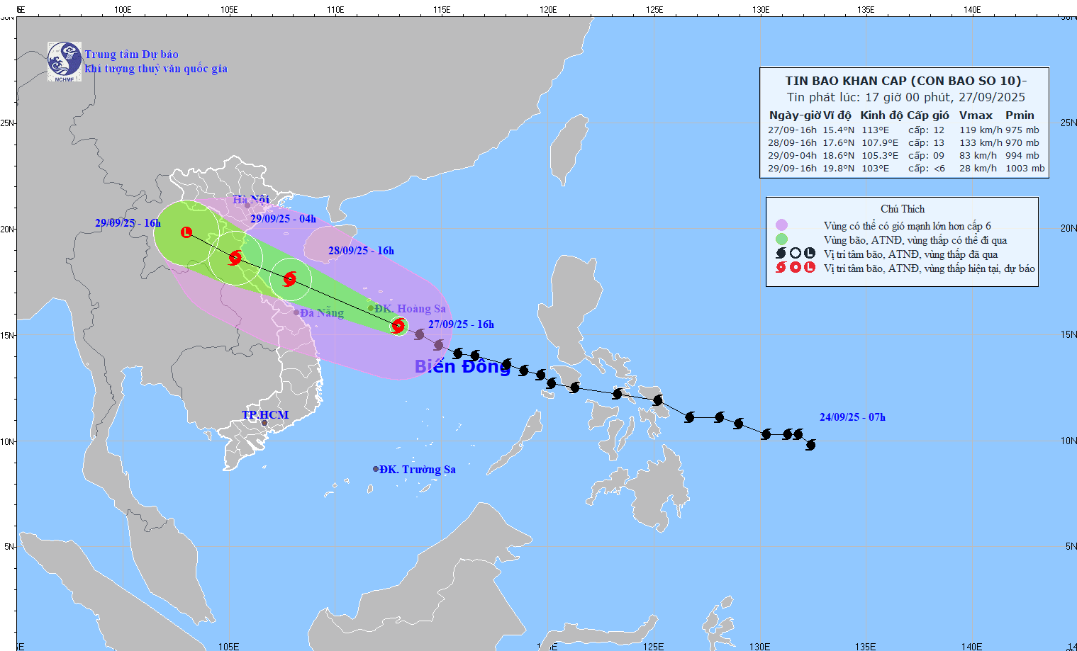
Latest update from the National Center for Hydro-Meteorological Forecasting, at 4:00 p.m. on September 27, the center of the storm was at about 15.4 degrees north latitude; 113.0 degrees east longitude, about 170 km east-southeast of Hoang Sa Special Zone. The strongest wind near the storm center is level 12 (118-133 km/h), gusting to level 15. The storm is moving west-northwest at a speed of 30-35 km/h.

Storm No. 10 is about to make landfall in Nghe An - north of Quang Tri
According to Mr. Mai Van Khiem - Director of the National Center for Hydro-Meteorological Forecasting, this is a storm that moves very quickly (nearly double the average speed), is strong, and has a wide range of influence.
"Storms can cause the combined impact of many types of natural disasters such as strong winds, heavy rain, floods, flash floods, landslides and coastal flooding" - Mr. Khiem warned.
It is forecasted that in the next 24 hours, the storm will move west-northwest at a speed of about 30 km/h, likely to strengthen.
At 4:00 p.m. on September 28, the center of the storm was at about 17.6 degrees north latitude; 107.9 degrees east longitude, in the waters of Quang Tri - Hue city, about 140 km east of Quang Tri. Strong wind level 12-13, gust level 16.
The danger zone is from latitude 13 to 20 degrees north; west of longitude 115.0 degrees east. Level 3 natural disaster risk for the northern and central East Sea (including Hoang Sa special zone); sea area from Ha Tinh to Quang Ngai.
"Around the evening of September 28, it will make landfall in Nghe An - North Quang Tri area" - Mr. Khiem said.
It is forecasted that in the next 36 hours, the storm will move west-northwest at a speed of 20-25 km/h.
At 4:00 a.m. on September 29, the center of the storm was at about 18.6 degrees north latitude; 105.3 degrees east longitude, on the mainland of Nghe An - north of Quang Tri. Strong wind level 9, gust level 11. The danger zone is 14.5 degrees north latitude north of the northern latitude; 110 degrees east of the western longitude. Level 4 natural disaster risk for coastal mainland areas from Nghe An to northern Quang Tri.
Level 3 natural disaster risk for the western sea area of the northern East Sea (including Hoang Sa special zone), from Thanh Hoa to Quang Ngai (including Hon Ngu island, Con Co and Ly Son special zone) and the northern Gulf of Tonkin (including Bach Long Vy, Van Don, Co To, Cat Hai special zone and Hon Dau island); mainland area from Ninh Binh to Hue city.
It is forecasted that in the next 48 hours, the storm will continue to move west-northwest at a speed of 20-25 km/h, weakening into a tropical depression, then a low pressure area.
At 4:00 p.m. on September 29, the center of the low pressure was at about 19.8 degrees north latitude; 103.0 degrees east longitude, in the Upper Laos area. Wind power below level 6. The danger zone is north of latitude 16 degrees north; west of longitude 107.5 degrees east. Level 3 natural disaster risk for provinces from Thanh Hoa to Quang Tri (including Hon Ngu island) and the northern Gulf of Tonkin (including Bach Long Vy, Van Don, Co To, Cat Hai and Hon Dau island); mainland area from Ninh Binh to Quang Tri.
The storm's western clouds cause early rain
According to the meteorological agency, at sea, the sea area west of the northern and central East Sea (including Hoang Sa special zone) will have strong winds of level 8-9, near the storm's eye will have winds of level 10-13, gusts of level 16, waves from 6.0 8.0-00 m high, near the storm's eye 8-10 m, the sea will be very rough.
The sea area from Thanh Hoa to Quang Ngai (including Hon Ngu island, Con Co and Ly Son special areas) will gradually increase to level 6-7, gusting to level 8-9, waves 3.0-5.0 m high, rough seas; from early morning of September 28, the wind will increase to level 8-9, near the storm center will be level 10-13, gusting to level 16, waves 5-7 m high, rough seas, extremely destructive power, extremely strong waves, which can sink heavy ships.
From early morning on September 28, the northern area of the Gulf of Tonkin (including Bach Long Vy, Van Don, Co To, Cat Hai and Hon Dau island) will gradually increase to level 6-7, then increase to level 8-9, gust to level 11, waves 3-5 m high, very rough seas, extremely dangerous for ships and boats.
Rising water in coastal areas and islands from Ninh Binh to Ha Tinh will have water rising from 0.5-1.5 m, while in the southern Thanh Hoa to northern Ha Tinh it will be 1.0-1.5 m high. There is a risk of flooding dykes, coastal roads, and riverbanks due to rising sea water and big waves in the evening and night of September 28.
The weather at sea and in coastal areas during the storm is extremely dangerous and unsafe for any vehicle or structure operating in the dangerous area such as tourist boats, passenger ships, transport ships, cages, aquaculture areas, dykes, embankments, coastal roads. Vehicles are likely to overturn or be destroyed, with the risk of flooding due to strong winds, large waves and rising sea levels.
According to Mr. Hoang Phuc Lam - Deputy Director of the National Center for Hydro-Meteorological Forecasting, the storm's large circulation and the western clouds of the storm caused early rain.
"Although at sea and the maximum intensity of storm No. 10 is not as strong as storm No. 9 Ragasa, because it is not too weakened, the impact on our mainland will be much stronger than storm No. 9" - Mr. Lam warned.
On land, from the afternoon of September 28, the wind from Thanh Hoa to north of Quang Tri will gradually increase to level 6-7, then increase to level 8-9, near the storm's eye level 10-12, gust level 14, which can cause very heavy damage. Coastal areas from Quang Ninh to Ninh Binh, from southern Quang Tri to Hue city, winds will gradually increase to level 6-7, gusting to level 8-9.
Regarding heavy rain, from the evening of September 27 to September 30, the North and the area from Thanh Hoa to Quang Ngai are likely to experience a widespread heavy rain with a total common amount of 100-300 mm, locally over 450 mm; in the Northern Delta, southern Phu Tho and from Thanh Hoa to northern Quang Tri, it is common to have over 600 mm.