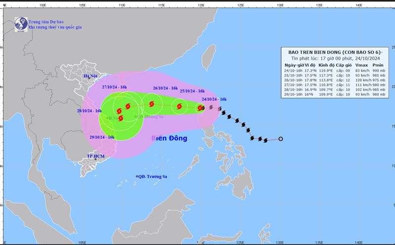
Latest update from the National Center for Hydro-Meteorological Forecasting, at 7:00 p.m. on October 24, the center of storm No. 6 Tra Mi was located at about 17.2 degrees north latitude; 119.7 degrees east longitude, in the eastern sea of the North East Sea area.
The strongest wind near the storm center is level 9 (75-88km/h), gusting to level 11. The storm moves west at a speed of 15km/h.
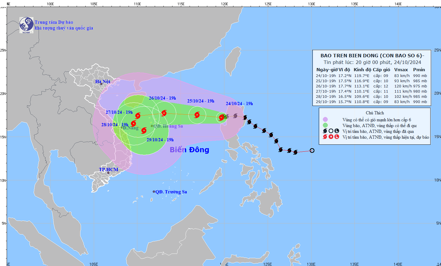
It is forecasted that in the next 24 hours, storm No. 6 will move westward at a speed of 10 - 15 km/h. At 7:00 p.m. on October 25, the center of the storm will be at approximately 17.5 degrees north latitude - 116.9 degrees east longitude; in the eastern sea of the North East Sea; 580 km east of the Hoang Sa archipelago.
The strongest wind near the storm center is level 9 - 10, gusting to level 12.
It is forecasted that in the next 48 hours, storm No. 6 will move westward at a speed of 15 - 20 km/h. At 7:00 p.m. on October 26, the center of the storm will be at approximately 17.7 degrees north latitude - 113.1 degrees east longitude; 210 km northeast of Hoang Sa archipelago.
The strongest wind near the storm center is level 11 - 12, gusting to level 15.
According to Mr. Nguyen Van Huong - Head of Division Weather Forecast, National Center for Hydro-Meteorological Forecasting, Directorate of Hydro-Meteorological Forecasting, storm No. 6 is under the influence of two other forms: cold air and a newly formed storm off the east of the Philippines.
"After October 26, storm No. 6 is likely to slow down, weaken and change direction. The possibility of making landfall is still unclear and needs to be monitored further," said Mr. Huong.
It is forecasted that in the next 72 hours, storm No. 6 will move westward at a speed of 10 - 15 km/h. At 7:00 p.m. on October 27, the center of the storm will be at approximately 17.4 degrees north latitude - 111 degrees east longitude; 200 km northwest of Hoang Sa archipelago.
The strongest wind near the storm center is level 11, gusting to level 13.
From the next 72 to 120 hours, the storm will move slowly in the west-southwest direction, traveling 5-10km per hour, then it may change direction to the south-southeast, and its intensity will tend to gradually weaken.
Regarding the impact of the storm, the eastern sea area of the North East Sea has strong winds of level 7, then increasing to level 8, the area near the storm's eye has winds of level 9 - 10 (75 - 102km/h), gusts of level 12, waves 5 - 7m high, the area near the storm's eye has 7 - 9m; the sea is very rough.
Ships operating in the above mentioned dangerous areas are likely to be affected by storms, whirlwinds, strong winds and large waves.