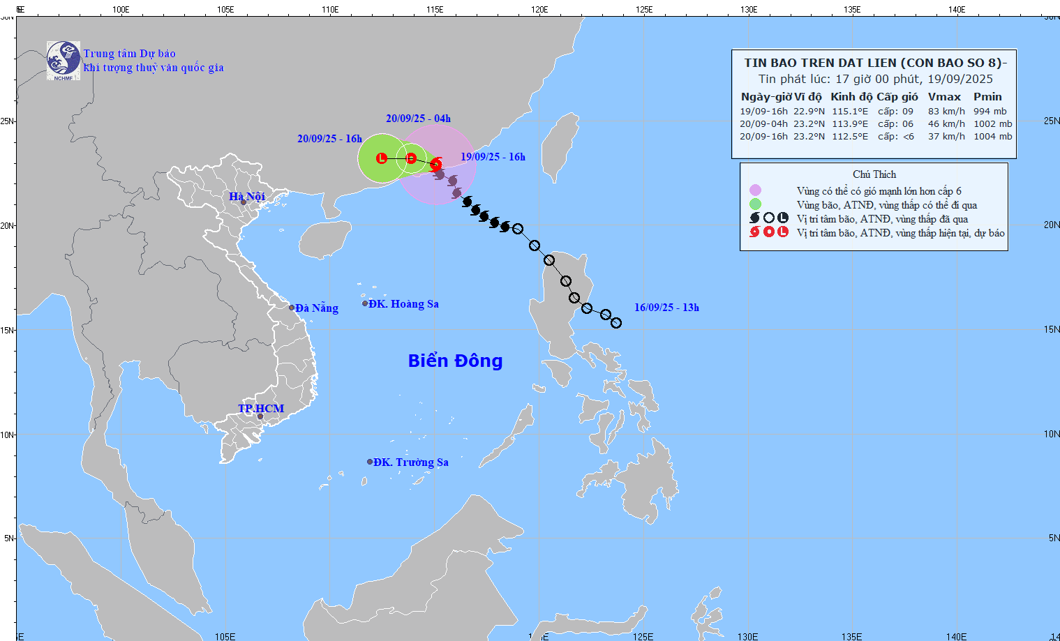
According to the National Center for Hydro-Meteorological Forecasting, at 4:00 p.m. on September 19, the center of storm No. 8 was at about 22.9 degrees north latitude, 115.1 degrees east longitude, in the mainland south of Guangdong province (China). The strongest wind near the storm center is level 8 - 9 (62-88km/h), gusting to level 11. The storm is moving northwest at a speed of about 10km/h.
It is forecasted that in the next 12 hours, the storm will move west-northwest at a speed of 10 - 15km/h and gradually weaken into a tropical depression.
At 4:00 a.m. on September 20, the center of the tropical depression was at about 23.2 degrees north latitude, 113.9 degrees east longitude, in the mainland south of Guangdong province (China). The strongest wind is level 6, gusting to level 8.
The dangerous area at sea is identified as the north of the 21st parallel north and between 113 - 117 degrees east longitude. The natural disaster risk level is level 3 for the northern sea area of the northern East Sea.
It is forecasted that in the next 24 hours, the tropical depression will continue to move westward at a speed of 10-15km/h, moving deep into the mainland and gradually weakening into a low pressure area.
At 4:00 p.m. on September 20, the center of the low pressure area was at about 23.2 degrees north latitude, 112.5 degrees east longitude, in the mainland south of Guangdong province (China). The strongest wind is below level 6.
Regarding the impact of the storm at sea, the sea area north of the northern East Sea will have strong winds of level 6 - 7, gusting to level 9; The area near the storm's eye will have strong winds of level 8, gusting to level 10, waves 3 - 4.5m high, rough seas. Ship operating in the above-mentioned dangerous areas are likely to be affected by thunderstorms, whirlwinds, strong winds and large waves.
According to the National Center for Hydro-Meteorological Forecasting, this morning (September 19), Typhoon Ragasa is active in the sea east of the Philippines, at risk of entering the East Sea.
At 7:00 a.m. on September 19, the center of the storm was at about 15.7 degrees north latitude; 131.9 degrees east longitude, about 1,000 kilometers east of Luzon Island (Philippines). The strongest wind is level 8 (from 62 to 74 km/h), gusting to level 10. The storm is moving northwest at a speed of about 10 km/h.
At 7:00 a.m. on September 20, the storm moved northwest, at a speed of about 10 km/h, likely to strengthen to level 10, gusting to level 12, at 16.8 degrees north latitude; 130.1 degrees east longitude.
At 7:00 a.m. on September 21, the storm continued to move northwest, at a speed of about 10 km/h, strengthening to level 12 to level 13, gusting to level 16, at 18.3 degrees north latitude; 128.2 degrees east longitude.
At 7:00 a.m. on September 22, the storm moved west-northwest, at a speed of 10 to 15 km/h, strengthening to level 14 to level 15, gusting above level 17, at 19.4 degrees north latitude; 124.8 degrees east longitude.
In the next 72 to 120 hours, the storm will continue to move mainly in the west-northwest direction, at a speed of about 20km per hour and is likely to strengthen.
Regarding the impact of this storm, from the afternoon and night of September 22, the northeastern sea area of the East Sea will have strong winds of level 6 to level 7, then increase to level 8 to level 9.
From September 23, the northern East Sea area (including Hoang Sa archipelago) will be directly affected by storm Ragasa with very strong intensity, level 14 to level 16, gusting above level 17. Waves over 10m high, rough seas, especially dangerous for ships operating in the northern and central East Sea.