Storm Tra Mi is about to weaken into a tropical depression
Latest update from the National Center for Hydro-Meteorological Forecasting, due to the influence of storm No. 6, Con Co Island (Quang Tri) has strong winds of level 8, gusts of level 9; Cu Lao Cham Island (Quang Nam) has strong winds of level 8, gusts of level 10; Ly Son Island (Quang Ngai) has level 6, gusts of level 7; Le Thuy (Quang Binh) has strong winds of level 7, gusts of level 9; Nam Dong (Thua Thien Hue) has strong winds of level 8, gusts of level 10; Cam Le (Da Nang) has strong winds of level 8, gusts of level 9.
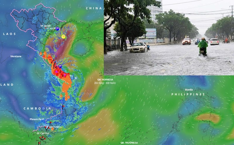
From last night to this afternoon (October 27), the area from Ha Tinh to Quang Nam has had heavy to very heavy rain. Total rainfall as of 1 p.m. on October 27, generally 100-250mm, locally over 400mm.
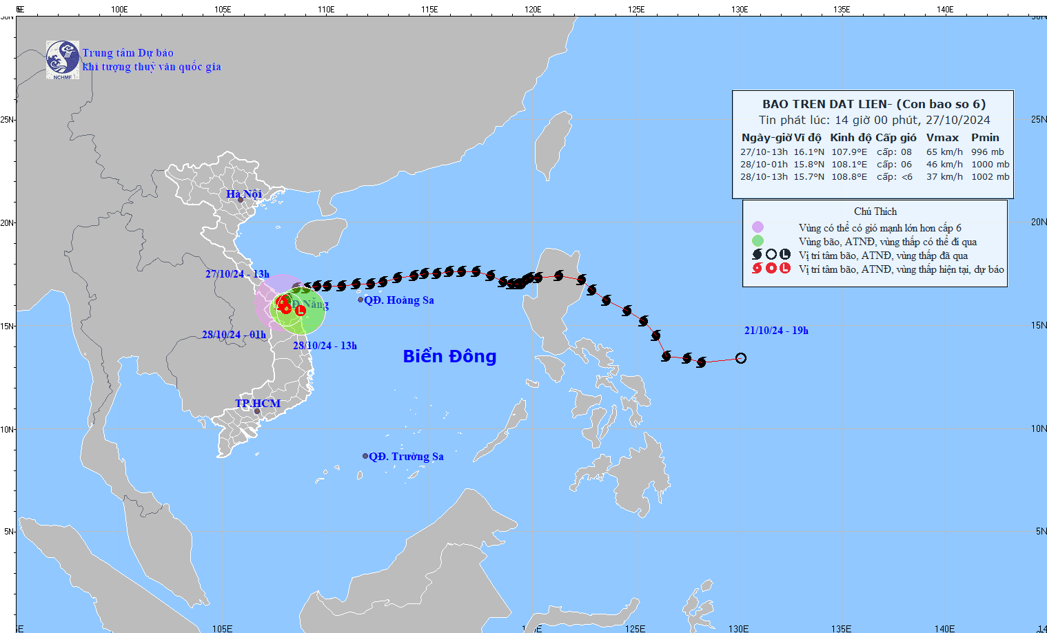
At 1 p.m. on October 27, the eye of the storm was located at approximately 16.1 degrees north latitude; 107.9 degrees east longitude, on the mainland of Thua Thien Hue, Quang Nam-Da Nang provinces. The strongest wind near the eye of the storm was level 8 (62 - 74 km/h), gusting to level 10. Moving southwest at a speed of approximately 10 km/h.
It is forecasted that in the next 12 hours, storm No. 6 will move south-southwest then southeast at a speed of 3-5km/h, weakening into a tropical depression. At 1:00 a.m. on October 28, the center of the tropical depression will be at about 15.8 degrees north latitude; 108.1 degrees east longitude; on the mainland of Thua Thien Hue, Quang Nam - Da Nang.
The strongest wind near the center of the tropical depression is level 6, gusting to level 8.
It is forecasted that in the next 24 hours, storm No. 6 will move east at a speed of 3 - 5 km/h, weakening into a low pressure area. At 13:00 on October 28, the center of the tropical depression will be at about 15.7 degrees north latitude; 108.8 degrees east longitude; in the coastal waters of Thua Thien Hue - Quang Nam.
The strongest wind near the center of the tropical depression is below level 6.
Storm Tra Mi will cause very heavy rain from now until the end of the night of October 28.
Regarding the impact of the storm at sea, the sea areas of the provinces from Quang Binh to Quang Ngai (including Con Co Island and Cu Lao Cham) have strong winds of level 6 - 7, near the storm center level 8, gusting to level 10, waves 3 - 5m high; rough seas.
Coastal areas from Quang Binh to Quang Nam provinces are likely to experience storm surges of 0.4 - 0.6m high.
Ships/boats operating in coastal areas from Quang Binh to Quang Ngai are likely to be affected by storms, whirlwinds, strong winds, and big waves.
High risk of flooding in low-lying coastal areas, landslides of dykes and sea embankments in coastal provinces from Quang Tri to Quang Nam due to the impact of big waves and storm surges
On land from Quang Binh to Quang Nam, there are strong winds of level 6, gusting to level 7 - 8; near the storm center, level 8, gusting to level 10.
From October 27 to the end of the night of October 28, the area from Quang Binh to Quang Nam will have heavy to very heavy rain with total rainfall ranging from 200 - 400mm, locally over 600mm. Warning of the risk of local heavy rain (greater than 100mm/3 hours).
Ha Tinh, Quang Ngai, Binh Dinh and the Northern Central Highlands have heavy rain, locally very heavy rain with total rainfall ranging from 100 - 200mm, in some places over 250mm.