
Updated bulletin issued at 9:00 AM from Son La Hydrometeorological Station, in the past 6 hours (from 1:00 AM to 7:00 AM on August 5, 2026), the water level rose rapidly on the Nam Pan River. At 7:00 AM on August 5, 2026, the water level at Hat Lot hydrological station is at 514.05m, 0.55m higher than alarm level 3:, 3.23m lower than the historic flood in August 2018:
From about 1 pm to 7 pm on August 5, 2026, the water level at Hat Lot hydrological station is likely to reach 514.50m, 1m higher than alarm level 3: 1m, 2.78m lower than the historic flood in August 2018 and continues to maintain at alarm level 3.
The meteorological agency warns that rising river water levels will cause flash floods, landslides, and flooding in low-lying areas along the river.
In addition, due to the impact of heavy rain in recent days, there is a high risk of flooding in some commune/ward areas.
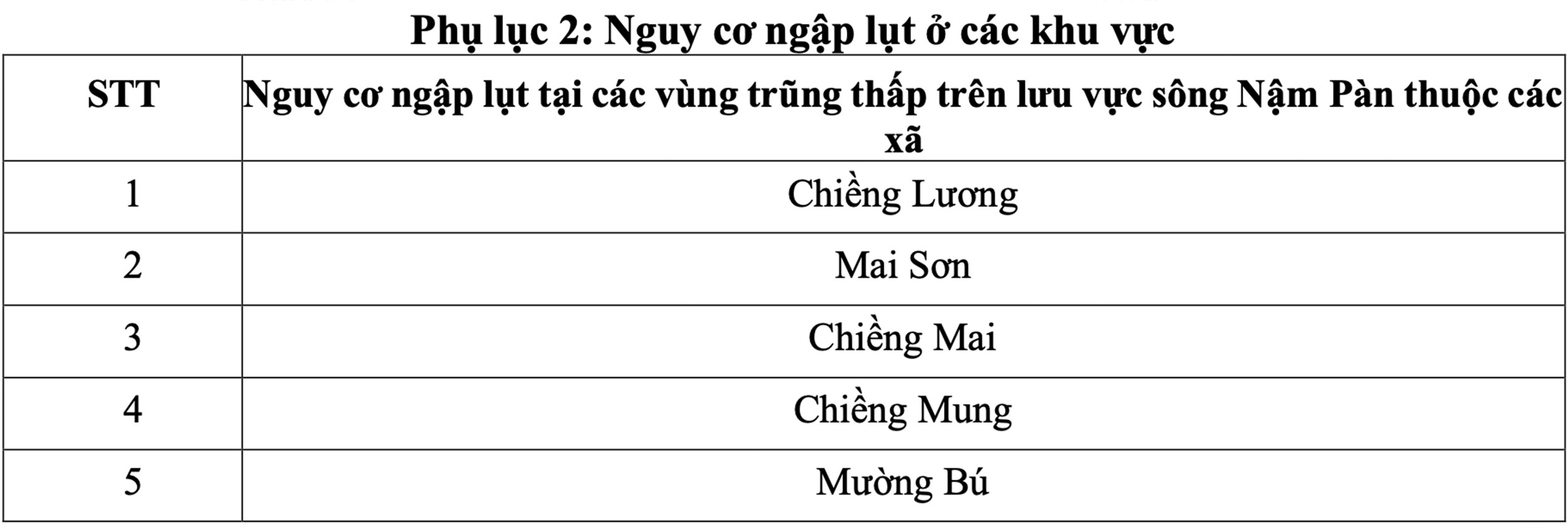
The meteorological agency also warned of a high risk of flash floods and landslides on small rivers and streams, landslides in hillside areas, slopes of traffic routes; land subsidence in areas with poor soil structure in the province.
Localities with suspension bridges and underground spillways on small rivers and streams need to warn people to pay attention when moving through during heavy rains and floods.
Warning level of natural disaster risk due to floods is level 2.
Son La Hydrometeorological Station also noted that the water level on rivers and streams is rising at a high level, so there is a high risk of landslides, flooding in low-lying areas, riverside areas, destroying bridges, culverts, and traffic roads in river and stream areas.
Floods, floods, flash floods and landslides affect human lives, aquaculture, agricultural production, people's livelihoods and socio-economic activities.


