Mr. Hoang Phuc Lam - Deputy Director of the National Center for Hydro-Meteorological Forecasting, issued warnings about the impact of storms on the mainland and sea of Vietnam in the coming days.

On land
Regarding strong winds from the afternoon of September 28, on the mainland from Thanh Hoa to North Quang Tri, the wind will gradually increase to level 6 - 7, then increase to level 8 - 9, the area near the storm's eye will have level 10 - 12 (the wind can cause trees, houses, electric poles to fall, causing very heavy damage), gust level4; coastal areas from Quang Ninh to Ninh Binh, from South Quang Tri to Hue City, the wind will gradually increase to level 6 - 7 ( Trees shake, difficult to get back on the wind), gust level 8 - 9.
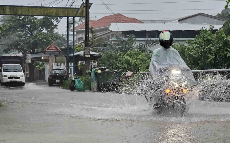
From the evening of September 27 to September 30, in the North and the area from Thanh Hoa to Quang Ngai, there is a possibility of a widespread heavy rain with total rainfall ranging from 100 - 300mm, locally over 450mm; in the Northern Delta, South Phu Tho and from Thanh Hoa to the North of Quang Tri, it is common to have 200 - 400mm, locally over 600mm.
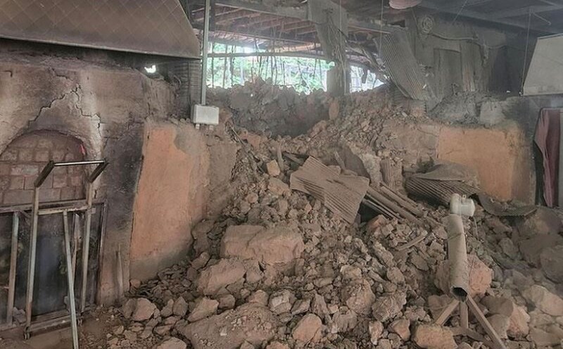
Heavy rain is likely to cause flooding in low-lying areas, urban and industrial areas; flash floods on small rivers and streams, landslides on steep slopes.
At sea
From the evening of September 27, the sea area from Thanh Hoa to Quang Ngai (including Hon Ngu island, Con Co and Ly Son specialties) will have winds gradually increasing to level 6 - 7, gusting to level 8 - 9, waves 3 - 5 m high, rough seas.
From early morning on September 28, the wind increased to level 8 - 9, the area near the storm center passed level 10 - 13, gusting to level 16, waves 5 - 7 m high, rough seas (extremely strong destructive power, extremely strong waves). Sinking a ship with a large weight).
For the Gulf of Tonkin area (including Bach Long Vy, Van Don, Co To, Cat Hai and Hon Dau island specialties), it is forecasted that from early morning on September 28, the wind will gradually increase to level 6 - 7, then increase to level 8 - 9 (very rough seas, very dangerous for ships), gusts of level 11, waves 3 - 5 m high, very rough seas.
Flood warning on rivers
Mr. Hoang Van Dai - Deputy Director of the National Center for Hydro-Meteorological Forecasting, issued a warning of flood risk on rivers in Vietnam before and after storm No. 10 Bualoi made landfall.

Accordingly, currently, the water level on the main rivers in the Red - Thai Binh river system, downstream of the main rivers from Thanh Hoa to Hue city fluctuates and is below the warning level (BD)1.
In particular, the water level on the Chu River (Thanh Hoa) at Cua Dat station is above level 3 (due to local heavy rain and discharge from Cua Dat hydropower plant); Kien Giang River at Le Thuy station, Ben Hai River at Gia Vong station is rising and above level 1.
Warning from September 27 to October 1, floods will appear on rivers in the Northern region, from Thanh Hoa to Hue city.
Flood peaks on Thao River (Lao Cai), Hoang Long River (Ninh Binh), Buoi River, Ma River, upstream of Chu River (Thanh Hoa), upstream of Ca River (Nghe An), Ngan Sau River, Ngan Pho (Ha Tinh), Kien Giang River (Quang Tri) and small rivers will rise to level 2 - level 3 and above level 3; flood peaks at Hoa Binh Lake (Phu Tho), on Lo River (Tuyen Quang), downstream of Chu River, downstream of Ca River, La River (Ha Tinh), Gianh River, Thach Han River (Quang Tri), Huong River, Bo River (Hue City) will rise to level 1 - level 2 - level 2 and above level 2. Widespread flooding risk in Dong Bang in the North, from Thanh Hoa to Bac Quang Tri (threatened by deep flooding from Thanh Hoa to Ha Tinh).
Warning of the risk of flash floods and landslides is very high in mountainous areas of the Northern provinces and from Thanh Hoa to Da Nang, especially Phu Tho, Lao Cai, Thanh Hoa - Ha Tinh.
Given the dangerous nature of the storm, the Deputy Director of the meteorological agency recommended that people should proactively move their assets, people and livestock out of low-lying areas, along rivers and streams, where there is a risk of deep flooding, flash floods and landslides. Limit travel through spillways, weak bridges, and deeply flooded roads; do not fish, collect firewood, or anchor boats in high water areas. Solidarate houses, works, warehouses; store food, clean water, medicine, flashlights, and spare batteries for use during prolonged floods.