The National Center for Hydro-Meteorological Forecasting has issued a weather trend forecast for July 2025.
Regarding temperature trends, the average temperature in many places is generally approximately the average of many years in the same period, especially in the South Central Coast and South, there are places 0.5 - 1 degree Celsius higher than the average of many years in the same period.
Hot weather is likely to occur in the Northern region, Thanh Hoa to Hue and the South Central Coast, with the intensity not as severe as in the same period in 2024.
In the area from Thanh Hoa to Hue and the South Central Coast during this period, there is a high possibility of heat and sunshine, especially in the South Central Coast, leading to drought, water shortage and a very high risk of fire and explosion.
Total rainfall in the North and provinces from Thanh Hoa to Quang Tri is generally 20 - 50% higher than the average of many years in the same period; the remaining areas are generally 5 - 15% lower than the average of many years in the same period.
During the forecast period, the Northern region, Thanh Hoa to Ha Tinh are likely to experience some widespread heavy rains. In the Central and Southern highlands, it is forecasted to continue to have many thunderstorms, with some days having heavy to very heavy rain, the rain will be concentrated in the late afternoon.
On a national scale, there is a continued possibility of dangerous weather phenomena such as thunderstorms, tornadoes, lightning, hail and strong gusts of wind.
The phenomenon of heavy rain and thunderstorms, whirlwinds, and lightning can negatively affect production activities and public health. In particular, beware of localized heavy rains that can cause floods, inundation in low-lying areas and landslides in mountainous areas.
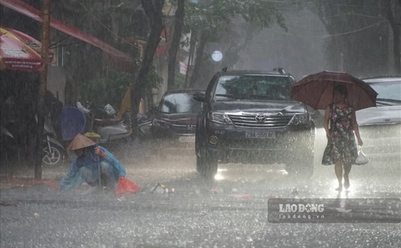
Previously, in June, there were many rainy days in the Northwest and Northeast regions, including widespread heavy rains.
Notably, the rain from June 20 to 23, due to the influence of the low pressure trough being compressed combined with wind convergence at the upper atmospheric levels, the area had moderate rain, heavy rain, locally very heavy rain with total rainfall of 50 - 200mm, some places were higher such as in Bac Quang (Tuyen Quang) 339mm, Thai Nguyen 360mm....
The Central region experienced 2 scattered rains and 1 widespread rain in June.
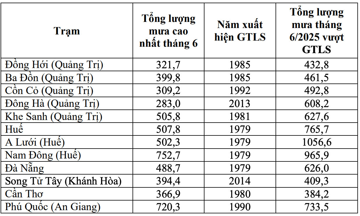
Notably, the rain from June 10 to 13, due to the influence of the circulation of storm No. 1, the area from South Ha Tinh to Quang Ngai will have heavy to very heavy rain with common rainfall of 250 - 500mm, some places over 600mm; the North of Ha Tinh and Quang Ngai will have common rainfall of 100 - 200mm, some places over 250mm.
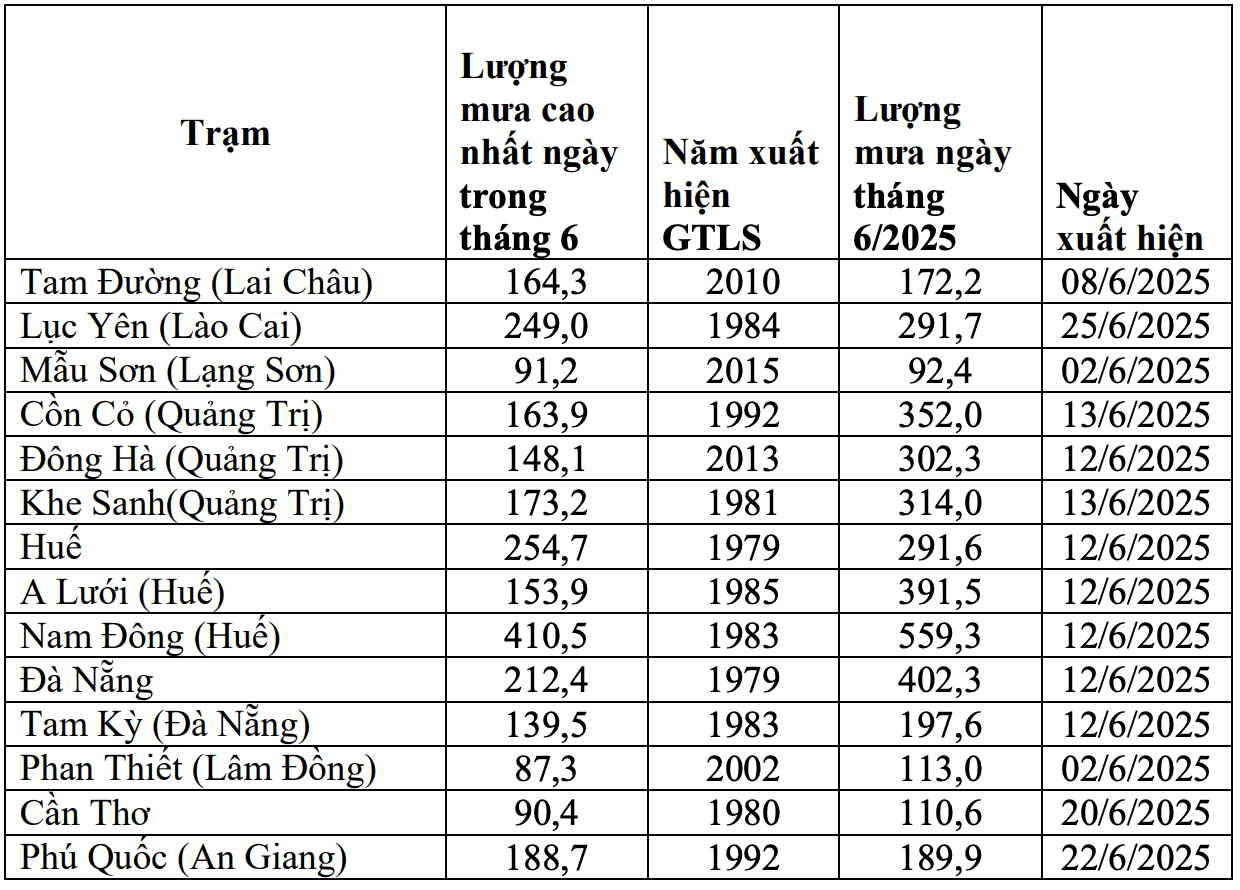
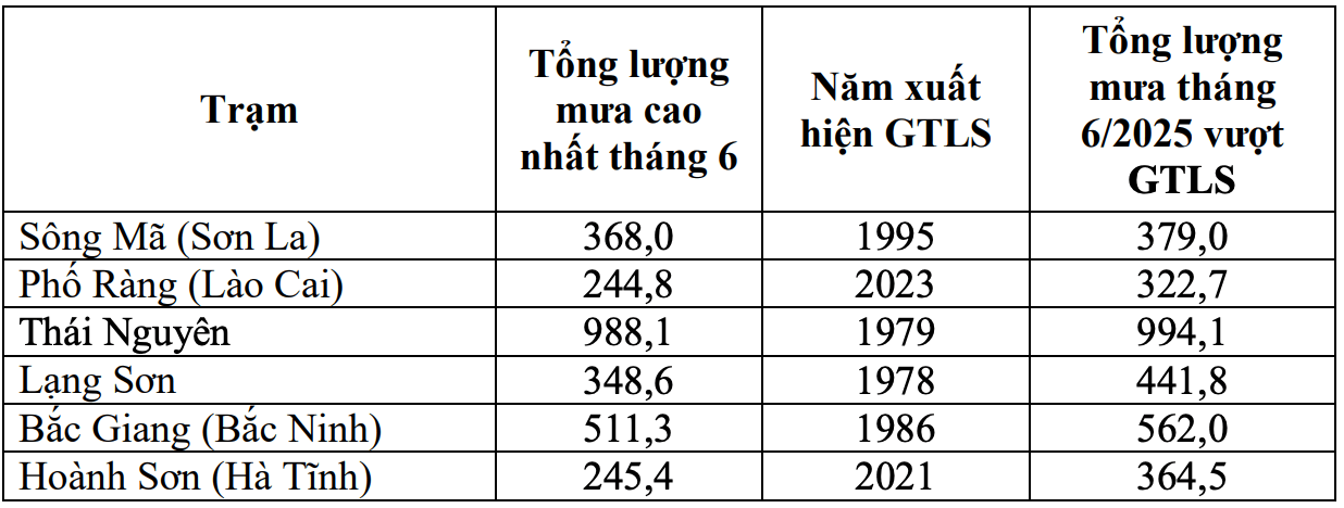
The Central Highlands and the South will experience many days of showers and thunderstorms, including days of moderate to heavy rain. Some stations recorded the highest rainfall of the day and month exceeding the historical value.
Regarding dangerous phenomena at sea, in July, the number of storms or tropical depressions in the East Sea is likely to be at a level similar to the average of many years and may affect our mainland. According to the average data of many years in July, there will be about 1.6 storms or tropical depressions in the East Sea (ie 1 - 2 storms); 0.9 storms (ie 0 - 1 storm) will make landfall.
Storms, tropical depressions and the southwest monsoon are likely to cause strong winds, large waves at sea and affect the activities of ships.
Previously, in June, there was 1 storm and 1 tropical depression in the East Sea.