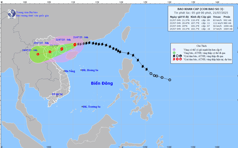
Typhoon No. 3 Wipha is about to enter the Gulf of Tonkin. The latest update at 9:00 a.m. on July 21, the center of the storm was at about 21.3 degrees north latitude; 109.7 degrees east longitude, about 200 km east of Quang Ninh - Hai Phong. The strongest wind near the storm center is level 9 (75-88 km/h), gusting to level 11. It is forecasted that in the next 3 hours, the storm will move west-southwest, at a speed of about 15-20km/h.

The storm is expected to cause many notable impacts before making landfall. Speaking to Lao Dong Newspaper reporters this morning, July 21, Mr. Mai Van Khiem - Director of the National Center for Hydro-Meteorological Forecasting provided information on the provinces and cities most affected by storm No. 3 Wipha.
Accordingly, regarding strong coastal winds, coastal provinces of Hung Yen, Ninh Binh, Thanh Hoa are areas that need special attention. Previously, the meteorological agency also warned that coastal areas from Quang Ninh to Nghe An will have winds gradually increasing to level 7 - 9, near the storm center level 10 - 11, gusting to level 14. The deep inland area has strong winds of level 6, gusting to level 7 - 8. Winds of level 10 - 11 can cause trees, electric poles to fall, and roofs to fall, causing very heavy damage.
According to Mr. Khiem, the rising water is forecast to be concentrated along the coast from Quang Ninh - Hung Yen (on the afternoon of July 22). Coastal areas from Hung Yen to Quang Ninh have storm surge of 0.5-1 m. The water level at Hon Dau (Hai Phong) is 3.7-4.1 m high, at Cua Ong (Quang Ninh) is 4.4 4.8 m high and at Tra Co (Quang Ninh) is 3.6-4 m high. There is a high risk of flooding in coastal areas and river mouths on the afternoon of July 22.
"Regarding heavy rain, Hung Yen, Ninh Binh, Hanoi, Nam Phu Tho, Thanh Hoa, Nghe An are forecast to be the focus areas for rain. The common rainfall is from 200 - 350 mm, in some places over 600 mm" - Mr. Khiem provided forecast information.
Previously, the meteorological agency also warned in the emergency storm bulletin that from July 21 to July 23, in the northeastern region, the Northern Delta, Thanh Hoa and Nghe An, there will be heavy to very heavy rain and thunderstorms with common rainfall of 200-350 mm, locally over 600 mm.
Other places in the northern region and Ha Tinh will have moderate rain, heavy rain, locally very heavy rain and thunderstorms with common rainfall of 100-200 mm, locally over 300 mm. Warning of the risk of heavy rain over 150 mm in 3 hours.
The Director of the meteorological agency also pointed out the risk of flash floods, landslides and urban flooding due to heavy rain.
"S canals and landslides are forecast to be concentrated in the areas of Quang Ninh, Son La, Nam Phu Tho (old Hoa Binh), the west of Thanh Hoa and Nghe An provinces. Regarding the safety of dams, attention should be paid to Ban Ve (Nghe An), Cua Dat, Trung Son (Thanh Hoa). Regarding urban flooding, industrial clusters need to pay attention to the areas of Phu Tho, Bac Ninh, Hanoi, Hung Yen, Ninh Binh, Thanh Hoa, Nghe An" - Mr. Khiem warned.
described storm wind granting and impact level
- Strong storm winds of level 8 (17.2 - 20.7 meters/second, wind speed of 62 - 74 kilometers/hour) - gusts may be above level 10.
Impact: branches are prone to breakage, some large trees may have their roots blown off. Pedestrians are unable to move, strong winds clearly affect infrastructure.
- Strong storm winds of level 9 (20.8 - 24.4 meters/s, wind speed of 75 - 88 kilometers/hour) - gusts may be above level 11.
Impact: Strong winds, large trees may fall and break. Many weak structures can be damaged (roof brakes cause damage to unstable roofs). Road traffic is severely obstructed, signs and outdoor works are easily damaged or collapse. The sea is very rough, dangerous for ships and boats operating at sea.
- Storm level 10-11:
Strong storm winds of level 10 (24.5 - 28.4 meters/second, wind speed 89 - 102 kilometers/hour) - gusts may be above level 12.
Wind impact level 10: Strong winds can destroy large trees, many weak and unstable construction works can suffer serious damage. It is very dangerous for ships at sea and causes damage to wharves and wharves where ships take shelter from storms.
- Strong storm winds of level 11 (28.5 - 32.6 meters/s, wind speed 103 - 117 kilometers/hour) - gusts may be above level 13.
Wind impact level 11: Can cause serious damage to unstable works. It is very dangerous for boats and coastal residents. Infrastructure such as roofs and windows could be severely damaged.
- Level 12 storm:
- Strong storm winds of level 12 (32.7 - 36.9 meters/s, wind speed 118 - 133 kilometers/hour) - gusts may be above level 14. Impact: Excessive destructive power. Winds can blow away trees, completely destroying unstable construction works, causing heavy damage even to large buildings. Small ships that are not anchored or cushioned carefully can break and sink at ports and wharves.
- Storm level 13-14:
- Strong storm winds of level 13 (37.0 - 41.4 meters/second, wind speed 134 - 149 kilometers/hour) - gusts may be above level 15.
The wind has extremely great destructive power, causing some damage to houses and utility works. High waves and floods near the coast will destroy small structures, large structures may be damaged by debris impacting them.
- Strong storm winds of level 14 (41.5 - 46.1 meters/second, wind speed 150 - 166 kilometers/hour) - gusts may be above level 16.