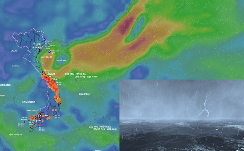
According to the National Center for Hydro-Meteorological Forecasting, in the past 24 hours, at Con Co station and Bach Long Vy station, there have been strong northeast winds of level 6, gusting to level 7.
It is forecasted that in the next 24 hours, cold air, tropical convergence zone combined with winter winds will continue to affect the sea weather.
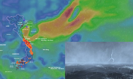
On the day and night of October 28, the sea area north of the North East Sea (including the sea area north of Hoang Sa special zone) will have strong northeast winds of level 6, sometimes level 7, gusting to level 8 - 9, rough seas, waves 3 - 5m high.
The Gulf of Tonkin and the sea area from southern Quang Tri to Quang Ngai will have strong northeast winds of level 6, gusting to level 7 - 8, rough seas, waves from 2.5 - 3.5m high.
In addition, on the day and night of October 28, in the southern Gulf of Tonkin, the sea area from Quang Tri to Ca Mau, Ca Mau to An Giang, the Gulf of Thailand, the northern and central East Sea (including the special zone of Hoang Sa), the southern East Sea (including the special zone of Truong Sa) will have scattered showers and thunderstorms; in thunderstorms, there is a possibility of tornadoes, strong gusts of wind at level 6 - 7 and waves over 2m high.
On the day and night of October 29, the sea area north of the North East Sea (including the sea area north of Hoang Sa special zone) will continue to have strong northeast winds of level 6, gusting to level 8 - 9, rough seas, waves 3 - 5m high.
The Gulf of Tonkin and the sea area from southern Quang Tri to Quang Ngai will have strong northeast winds of level 5, sometimes level 6, gusting to level 7 - 8, rough seas, waves from 1.5 - 3m high, especially in the southern Quang Tri - Quang Ngai area from 2.5 - 3.5m.
The meteorological agency warns that the level of natural disaster risk at sea is level 2. All ships operating in the above areas are at high risk of being affected by strong winds and large waves.