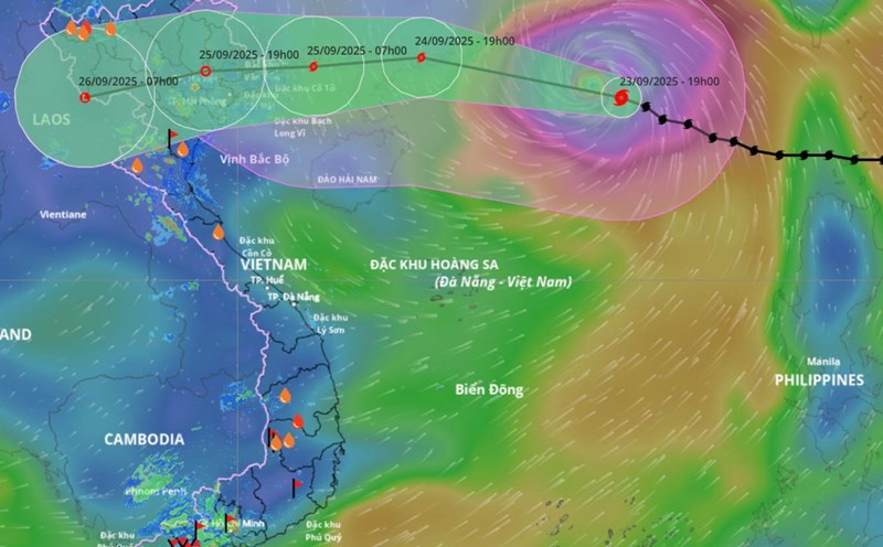
According to the National Center for Hydro-Meteorological Forecasting, while Typhoon No. 9 Ragasa had not yet dissipated, on the night of September 23, the tropical depression east of the Philippines strengthened into a storm and was given the international name Bualoi.
At 7:00 a.m. on September 24, the center of storm Bualoi was at about 9.8 degrees north latitude - 132.4 degrees east longitude. The strongest wind near the center is level 9 (75-88 km/h), gusting to level 11. The storm is moving west-northwest at a speed of about 15 km/h.
It is forecasted that around the night of September 26, the storm will enter the East Sea and become the 10th storm of 2025.
The National Center for Hydro-Meteorological Forecasting has forecasted the storm's developments in the next 24 to 72 hours.
At 7:00 a.m. on September 25, the center of storm Bualoi was at about 11.3 degrees north latitude - 129.7 degrees east longitude. The strongest intensity near the storm center is level 9 - 10, gusting to level 12.
At 7:00 a.m. on September 26, the center of storm Bualoi was at about 13.1 degrees north latitude - 124.8 degrees east longitude. The strongest intensity near the storm center is level 10, gusting to level 12.
At 7:00 a.m. on September 27, the center of storm Bualoi was at about 14.3 degrees north latitude - 118.6 degrees east longitude. The strongest intensity near the storm center is level 11, gusting to level 14.
The dangerous area is north of latitude 12 degrees north - 17 degrees north, east of longitude 117.0 degrees east. The natural disaster risk level is level 3 for the eastern sea area of the northern and central East Sea.
Warning in the next 72 - 120 hours, the storm will continue to move rapidly in the west-northwest direction, at a speed of 20-25 km/h, and is likely to strengthen.
Regarding the impact of the storm at sea, from the evening and night of September 26, the northeastern and central East Sea will have winds gradually increasing to level 6 - 7, then increasing to level 8 - 9. The area near the storm center is level 10 - 11, gusting to level 14, waves are 5-7 m high, the sea is very rough.
The meteorological agency warns of danger to ships operating in the northern and central East Sea.