According to the National Center for Hydro-Meteorological Forecasting, at 10:00 a.m. on September 24, the center of storm No. 9 Ragasa was at about 21.3 degrees north latitude; 113.2 degrees east longitude, about 570 km east of Mong Cai (Quang Ninh). The strongest wind near the storm center is level 15 (167-183 km/h), gusting over level 17. The storm is moving west-northwest at a speed of about 20 km/h.
Storm No. 9 weakens, however, the natural disaster risk level in some areas is at level 4
It is forecasted that in the next 24 hours, the storm will move west-northwest at a speed of about 20 km/h and gradually weaken.
At 10:00 on September 25, the center of the storm was at about 21.5 degrees north latitude; 108.5 degrees east longitude, in the coastal areas of Quang Ninh - Hai Phong provinces. Strong intensity level 10, gust level 12.
The danger zone is north of latitude 19 degrees north, west of longitude 116 degrees east. The natural disaster risk level is level 4 for the northwestern sea area of the North East Sea, level 3 for the northern Gulf of Tonkin and the northeastern coastal areas of the Ministry.
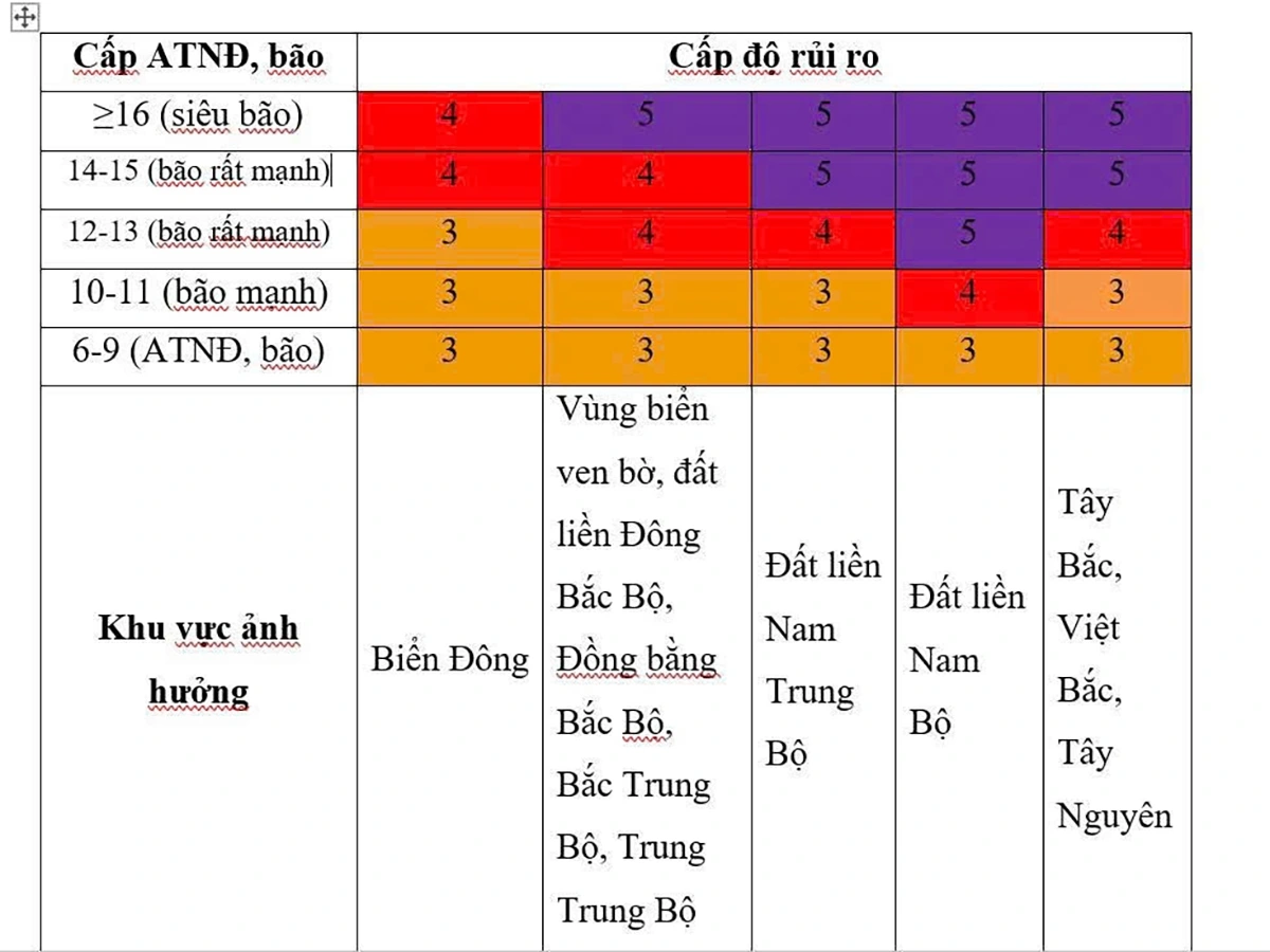
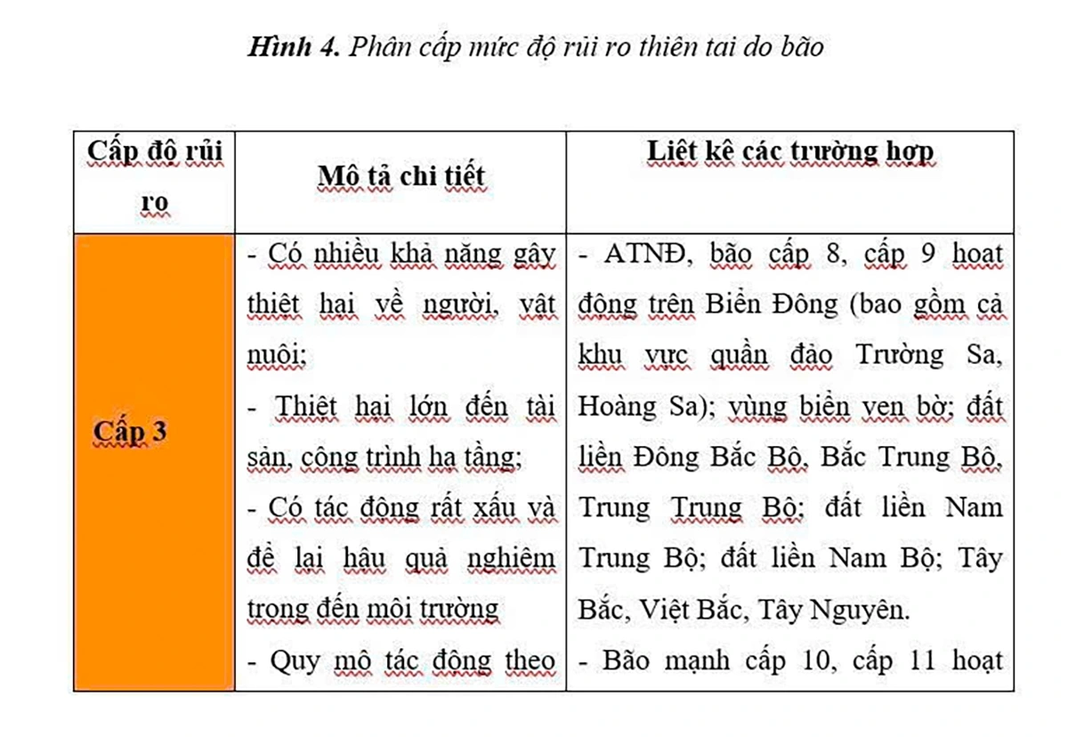
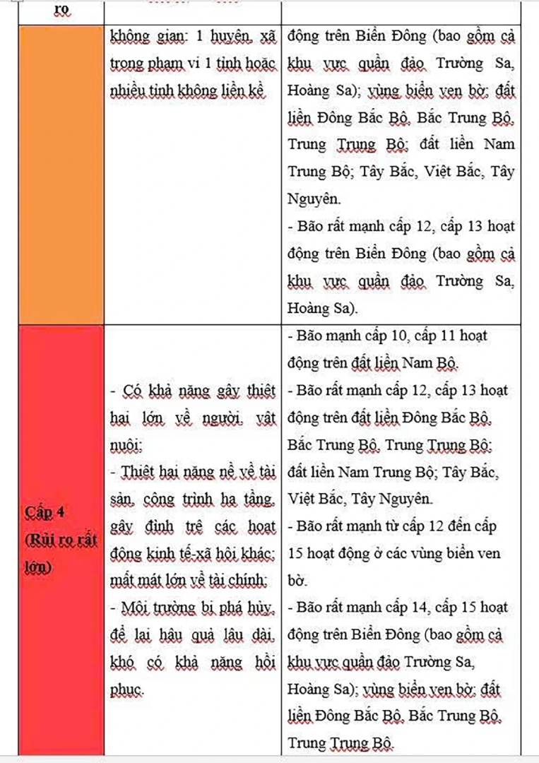
According to the meteorological agency, natural disaster risks are classified for each type of natural disaster based on the intensity, scope of impact, areas directly affected and the ability to cause damage by natural disasters.
The disaster risk level will be published with the content of the disaster forecast and warning bulletin and serve as a basis for the assignment, decentralization of responsibilities and coordination in responding to natural disasters.
The risk levels for natural disasters due to tropical depressions and storms are 3, the lowest is level 3 and the highest is level 5. Based on the description of speculation and assessment of the possibility of strong storms appearing in different areas of Vietnam, vulnerability, socio-economic conditions and disaster resilience in different regions of Vietnam, it is possible to relatively assess the risk level due to the impact of strong storms on different regions of Vietnam.
It is forecasted that in the next 48 hours, the storm will move westward at a speed of about 20 km/h, weakening into a tropical depression, then continuing to weaken into a low pressure area.
At 10:00 on September 26, the center of the low pressure area was at about 21.3 degrees north latitude; 104.1 degrees east longitude, on the mainland of the northwest of the North. Intensity below level 6.
The danger zone is 19.5 degrees north latitude north of the latitude, 110 degrees west of the longitude east of the latitude. Level 3 natural disaster risk for the northern Gulf of Tonkin and the northeastern coastal area.
Heavy rain in the North from tonight, September 24
Regarding the impact of the storm at sea, the northwestern sea area of the northern East Sea will have strong winds of level 10-12, the area near the center of the storm will have winds of level 13-15, gusts above level 17, waves above 10 m high, and rough seas.
The eastern sea area of the northern Gulf of Tonkin (including Bach Long Vi) has strong winds of level 6-7, gusting to level 9. From the night of September 24, the northern area of the Gulf of Tonkin (including Bach Long Vi, Van Don, Co To, Cat Hai and Hon Dau island) will gradually increase to level 7-8, near the storm's eye level 9-11, gusting to level 13, waves 3-5 m high, and rough seas.
The coastal waters of Quang Ninh have storm surges of 0.4-0.6 m high. Ship anchorage and coastal aquaculture areas are affected by strong winds, high waves and rising water.
On land, from early morning on September 25, coastal areas from Quang Ninh to Hung Yen will have winds gradually increasing to level 6-7, near the storm center level 8-9, gusting to level 11. The deep inland area northeast of the Ministry has strong winds of level 5, some places level 6, gusting to level 7-8.
Regarding heavy rain, from the night of September 24 to the end of the night of September 26, in the northern region, Thanh Hoa and Nghe An, there will be heavy to very heavy rain with common rainfall of 100-250 mm, some places over 400 mm. Warning of the risk of flooding in low-lying areas; flash floods on small rivers and streams and landslides on steep slopes.
Due to the wide influence of the storm's circulation, it is necessary to be on guard against the risk of thunderstorms, tornadoes and strong gusts of wind both before and during the storm's landfall.