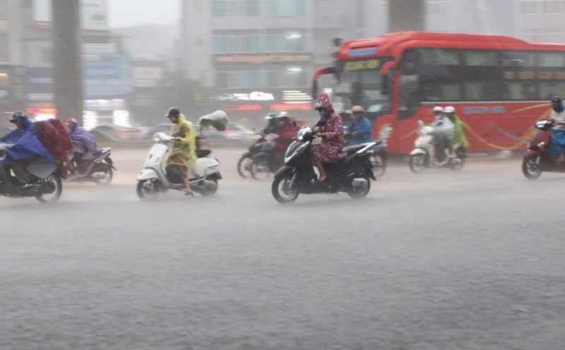
According to the Northern Hydrometeorological Station, today, September 30, Hanoi will have heavy to very heavy rain and thunderstorms. Rainfall from 7am to 1pm on September 30 was generally from 50 - 100 mm, some places were larger such as Kim Anh 229.8 mm, Dinh Cong 161.2 mm, Phu Thuong 140.6 mm, Soc Son 138 mm, Dong Anh 123.4 mm, Dai Thanh 118.3 mm.
Reporter of Lao Dong Newspaper discussed with Mr. Vo Van Hoa, Director of the Northern Hydrometeorological Station about the development of heavy rain in Hanoi.

Sir, what is the cause of heavy rain and discharge in Hanoi on September 30?
- There are two causes for this rain. The first reason is that the low pressure area weakening from storm No. 10 Bualoi is still maintained in the northeastern part of Myanmar, on the other hand, there is also a low pressure area in the Bay of Bengal creating a humid southwest wind aspiration area developing up to 5,000m from the Bay of Bengal moving to the Northern region.
The second reason is that the activity of the subtropical high pressure has a strong and stable intensity, bringing the humid Southeast wind zone from the East Sea to the Northern region.
The convergence of the southwest and southeast winds to a level of over 5,000m (easterly convergence) is the cause of this heavy rain.
What is the forecast for the next developments in the rain situation in Hanoi and when will the heavy rain gradually decrease, sir?
- The wind convergence area up to a level of over 5,000m is still maintained, so there is a possibility of heavy rain continuing this afternoon and evening.
From tonight, the activity of the southwest wind zone tends to weaken (due to the weakening of the low pressure area from storm No. 10 in Myanmar continuing to weaken and gradually dissipate), the subtropical high pressure will encroach to the west, leading to the wind convergence area in the Northern region tending to weaken, so from tonight, heavy rain will gradually decrease, from tomorrow morning, October 1, the rain will decrease.
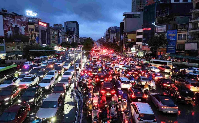
Regarding the flooding situation, from tonight, due to heavy rain gradually decreasing, the flooding situation in Hanoi depends largely on the ability of the urban drainage and drainage system.
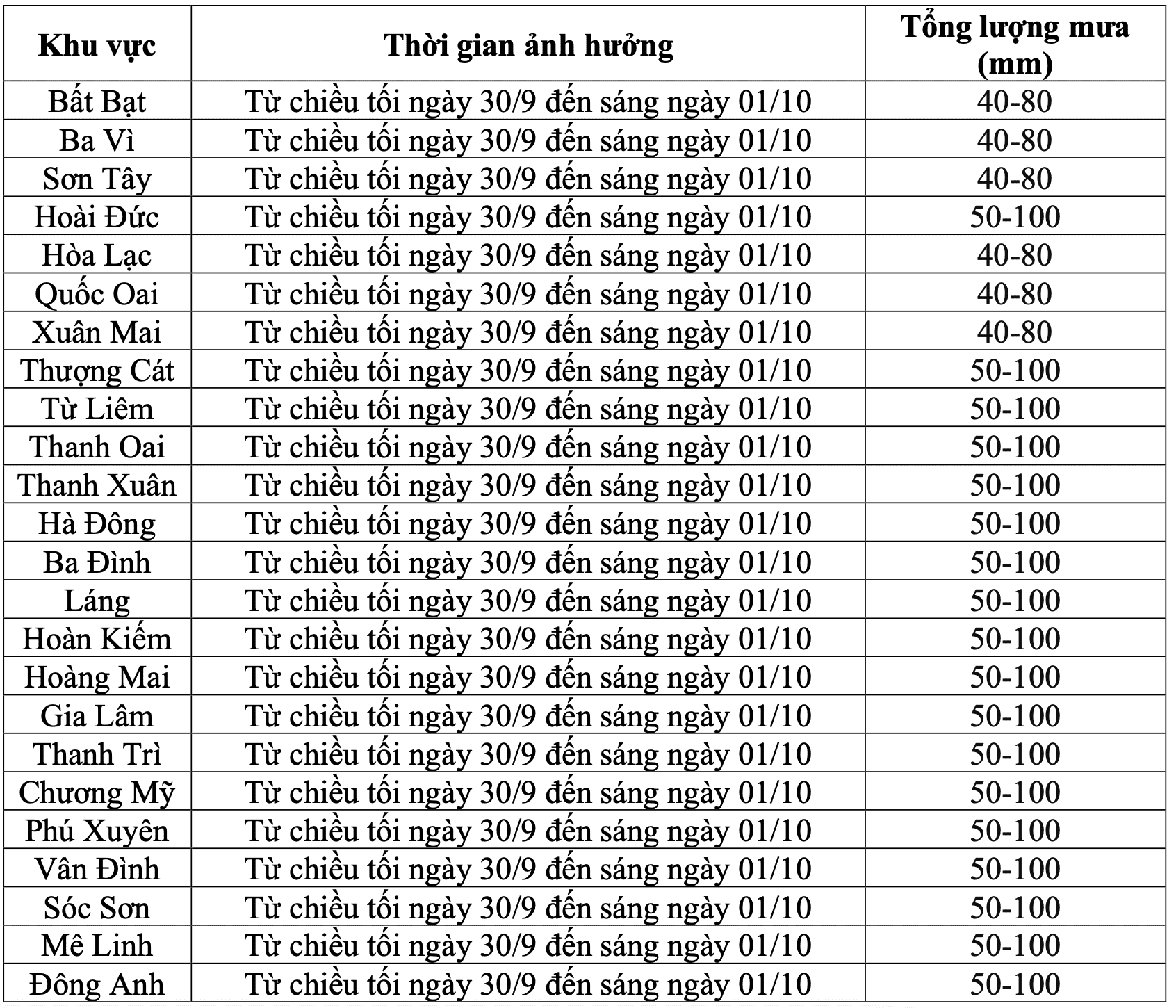
Regarding the common rainfall tonight to tomorrow morning, October 1, it will be from 40 - 100 mm, in some places over 150 mm. From noon and afternoon on October 1, there will be rain, showers and thunderstorms. Warning of heavy rain with more than 100mm of rainfall in 3 hours. From October 2, Hanoi will have scattered showers and thunderstorms.

What recommendations do you have when the heavy rain in Hanoi is still continuing?
- Heavy rain can cause impacts such as thunderstorms with the possibility of tornadoes, lightning and strong gusts of wind that break trees, damage houses, traffic works and infrastructure.
moderate rain, heavy rain to very heavy rain in a short time overloaded the urban drainage system, causing flooding in residential areas, urban areas and low-lying areas, traffic congestion due to flooding, reduced visibility when driving, causing slippery and accidents; heavy rain in a short time can cause landslides in mountainous areas, where the terrain is steep.
Sincerely thank you!
Flood warning bulletin in Hanoi
In the bulletin issued at 4:30 p.m. on September 30 from the Northern Hydrometeorological Station, it also said that in the next 3 - 6 hours, Hanoi and neighboring areas will continue to have moderate to heavy rain, with total accumulated rainfall commonly between 40 - 80 mm, some places higher.
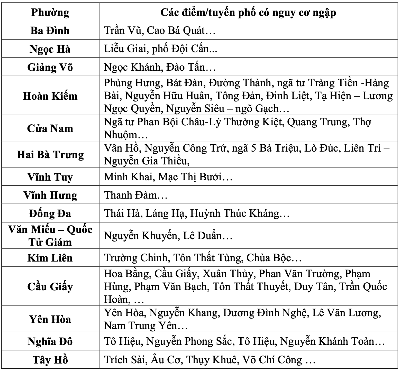
This rain will cause localized flooding for many streets with the largest common flooding depth of 0.2 - 0.6m, some places will be flooded deeper; the flooding time will last about 2 - 4 hours, some places will be flooded longer.
Heavy rain is likely to cause flooding on some streets, affecting vehicles participating in traffic; flooding some low-lying areas. In addition, it is necessary to be on guard against landslides in some communes and wards in suburban areas of Hanoi such as Ba Vi, Son Tay, etc.