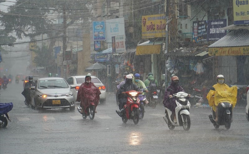
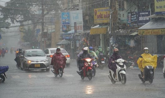
According to the National Center for Hydro-Meteorological Forecasting, last night and this morning (October 31), the area from Ha Tinh to Bac Quang Tri had heavy rain, locally very heavy rain. Rainfall from 7pm on October 30 to 8am on October 31 locally has monitoring stations measuring over 300mm such as: Ky Anh station (Ha Tinh) 324mm, Ba Don station (Quang Tri) 459.4mm,...
Heavy rain in the Central region lasts until around November 4
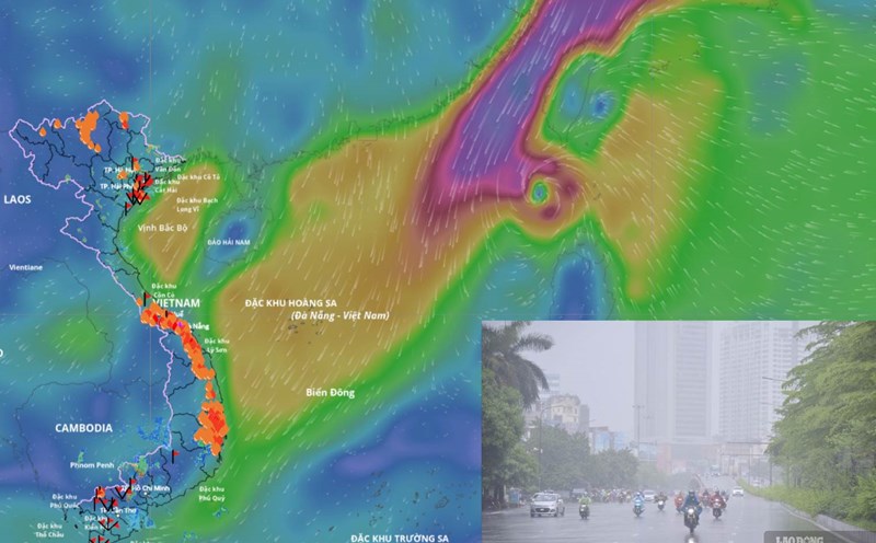
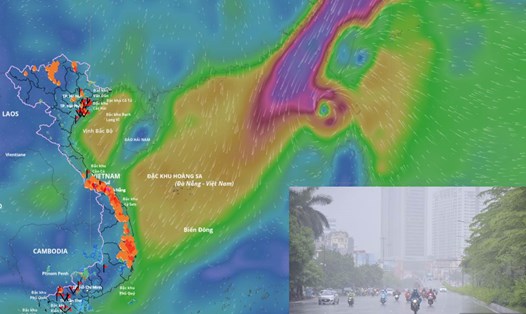
The area from Nghe An to northern Quang Tri is the focus of heavy rain from October 31 to the end of the night of November 1, forecast to have heavy to very heavy rain with common rainfall of 150 - 300mm, locally very heavy rain over 500mm.
The area from South Quang Tri to Da Nang city on October 31 is forecast to have moderate rain with rainfall of 15 - 30mm, locally heavy rain over 70mm. Warning of the risk of heavy rain with rainfall greater than 70mm in 3 hours.
From the night of October 31 to the end of the night of November 1, the area from southern Quang Tri to Quang Ngai will have heavy rain again with common rainfall from 100 - 250mm, locally very heavy rain over 350mm. Warning of the risk of heavy rain with rainfall greater than 150mm in 3 hours.

Mr. Mai Van Khiem - Director of the National Center for Hydro-Meteorological Forecasting, Department of Hydro-Meteorology - said that the cause of heavy rain is due to the combination of increased cold air combined with the tropical convergence zone with an axis maintained through the Central Central region and easterly wind disturbances operating in the atmospheric layers above the elevation from 1,500 - 5,000m.
"This is one of the very typical types of heavy rain in the Central region, the prolonged heavy rains are all caused by this weather combination" - Mr. Khiem emphasized.
Warning of the risk of flooding returning
Regarding the flood situation, according to the representative of the meteorological agency, in Ha Tinh, the water level on the rivers is rising slowly and is still below alert level 1. Currently, many places have been flooded, mainly in low-lying areas; Vung Ang ward (Ky Anh town) has some places flooded nearly 1m deep.
In Quang Tri, the flood on Gianh River in Dong Tam (Tuyen Hoa) has peaked and is receding, the water level at 6:00 a.m. on October 31 was at 10m, 2m below alert level 2; in Mai Hoa, the flood is peaking, the water level at 4:00 a.m. is 5.07m, 0.07m above alert level 2. On Kien Giang River (Le Thuy), the water level at 6am was 2.44m, above alert level 2 was 0.24m.
In Hue-Da Nang, the water level on the rivers is decreasing. At 7:00 a.m. this morning, the Bo River at Phuoc Oc was 3.39 m (0.39 m above alert level); the Huong River at Kim Long was 2.26 m (0.74 m below alert level); the Vu Gia River at Ai Nghia was 8.33 m (0.33 m above alert level); the Thu Bon River at Cau Lau was 3.6 m (0.4 m below alert level 3).
It is forecasted that in the next 12 - 24 hours, floods on rivers will continue to decrease, generally at alert level 1 - alert level 2; the Bo River and Thu Bon River will still be above alert level 2 by about 0.2 - 0.3m.
"From November 2 to 4, floods on rivers from Ha Tinh to Quang Ngai are likely to rise again. According to current forecast data, there is little chance of a particularly large flood like the flood on October 27-29" - Mr. Khiem said.
However, this expert also emphasized that the models' long-term forecasts are not highly reliable, and need to continue to be monitored and updated.
Previously, representatives of the meteorological agency also assessed the characteristics of the flood from October 27 to 30. Accordingly, from October 27 to October 29, on the main rivers in Hue city and Da Nang city, there were particularly large floods, with water levels on most rivers exceeding alert level 3, of which 5/12 measuring stations exceeded historical flood levels.
The Bo River (Hue city) at Phuoc station reached 5.27m (19am on October 29), 0.03m higher than the historical flood level in 2020 (5.24m).
Vu Gia River (Da Nang City) at Thanh My Station reached 27.20m (14:00 on October 29), 0.06m higher than the historical flood level in 2007 (27.14m); at Hoi Duong Station reached 19.32m (15:00 on October 29), 1.18m higher than the historical flood level in 2009 (18.14m).
Thu Bon River (Da Nang City) at Nong Son Station reached 18.68m (19:00 on October 29), 0.15m higher than the historical level in 1998 (18.53m); at Cau Lau Station reached 5.62m (2:00 on October 30), 0.14m higher than the historical level in 1964 (5.48m).