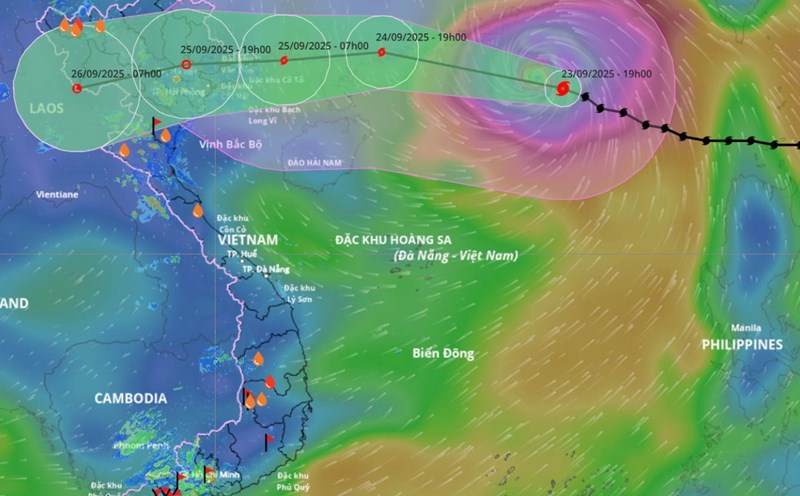
Latest update from the National Center for Hydro-Meteorological Forecasting, at 7:00 a.m., the center of storm No. 9 Ragasa was at about 21.3 degrees north latitude; 113.7 degrees east longitude, about 620 km east of Mong Cai (Quang Ninh).
The strongest wind near the storm center is level 15 (167-183 km/h), gusting over level 17. The storm is moving west-northwest at a speed of about 20 km/h.
It is forecasted that in the next 24 hours, the storm will move west-northwest at a speed of 20-25 km/h and gradually weaken.
At 7:00 a.m. on September 25, the center of the storm was at about 21.5 degrees north latitude; 108.8 degrees east longitude, in the waters of Quang Ninh - Hai Phong province. Strong intensity level 10-11, gust level 13.
The danger zone is 18.5 degrees north latitude north of the line, and 117.5 degrees east of the line west of the line. The natural disaster risk level is level 4 for the northern sea area of the North East Sea, level 3 for the northern Gulf of Tonkin and the northeast of the Ministry.
It is forecasted that in the next 48 hours, the storm will move west at a speed of 25-30 km/h, weakening into a tropical depression, then a low pressure area.
At 7:00 a.m. on September 26, the center of the low pressure was at about 21.3 degrees north latitude; 103.1 degrees east longitude, in the northwest mainland of the North; intensity below level 6.
The danger zone is 19.5 degrees north latitude north of the latitude, and 111.5 degrees east of the longitude west of the longitude. Level 3 natural disaster risk for the northwestern sea area of the northern East Sea, the northern Gulf of Tonkin and the northeastern part of the country.
Regarding the impact at sea, the sea area north of the northern East Sea will have strong winds of level 10-12, the area near the storm's eye will have winds of level 13-15, gusts above level 17, waves over 10m high, and rough seas.
From noon on September 24, the eastern sea area of the northern Gulf of Tonkin (including Bach Long Vy) will have winds gradually increasing to level 6-7, gusting to level 9. From the night of September 24, the northern area of the Gulf of Tonkin (including Bach Long Vy, Van Don, Co To, Cat Hai and Hon Dau) will gradually increase to level 8, with waves 2-4 m high; the area near the storm's eye will have strong winds of level 9-11, gusts of level 13, waves 3-5 m high, and rough seas.
The coastal areas of Quang Ninh province have storm surge of 0.4-0.6 m. Ship anchored along the coast, aquaculture areas are strongly affected by winds, big waves and rising sea water.
On land, from early morning on September 25, coastal areas from Quang Ninh to Ninh Binh will have winds gradually increasing to level 6-7, near the storm center level 8-9, gusting to level 11. The deep inland area northeast of the Ministry has strong winds of level 5, some places level 6, gusting to level 7-8.
Regarding heavy rain, from the night of September 24 to the end of the night of September 26, in the northern region, Thanh Hoa and Nghe An, there will be heavy to very heavy rain with common rainfall of 100-250 mm, locally over 400 mm. Heavy rain is likely to cause flooding in low-lying areas, flash floods on small rivers and streams and landslides in mountainous areas.