Recorded and announced from the Center for Earthquake Information and Tsunami Warning - Institute of Earth Sciences (Vietnam Academy of Science and Technology), the latest match occurred at 11:49 on October 6 in Mang But commune, with a scale of 4.0 on the Richter scale, a focal depth of about 8.1 km, and a natural disaster risk level 0. Previously, in the early morning of the same day, Mang Ri commune also had 4 consecutive earthquakes, of which the strongest match at 1-28 was at 4.9 degrees Celsius, with a natural disaster risk level 1.
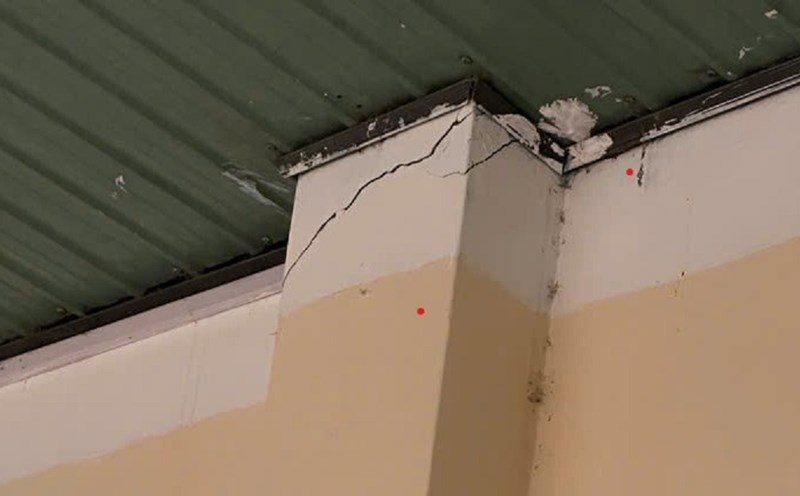
The strong shaking caused some constructions in the locality to be affected. The leader of Mang But commune said that Mang But Primary and Secondary School ( Facilities 2) had cracked walls and damaged tiled roofs. The government has inspected, counted the damage and instructed people on how to respond.
People in Son Tay (Quang Ngai) and Thong Nhat (Gia Lai), Tra My, Tien Phuoc communes (Da Nang) said they clearly felt the shaking, many items fell to the ground, the corrugated iron roofs made a loud noise. Although there were no human casualties, panic still engulfed the mountains.
According to the Institute of Earth Sciences, the Kon Plong area (old) - now part of Quang Ngai - is located in a weak earthquake zone, often experiencing earthquakes caused by reservoirs. From 2021 to now, there have been more than 200 earthquakes recorded here, but the maximum shaking did not exceed 5.5 degrees Celsius.