Updated from the National Center for Hydro-Meteorological Forecasting, due to the influence of storm No. 5, at Bach Long Vi station (Hai Phong), there were strong winds of level 7, gusting to level 9; Co To station (Quang Ninh) had strong winds of level 6, gusting to level 9; Bai Chay station (Quang Ninh) had strong winds of level 6, gusting to level 8; Hon Ngu station (Nghe An) had strong winds of level 7, gusting to level 8; Con Co station (Quang Tri) had strong winds of level 6, gusting to level 8.

Storm No. 5 will maintain its intensity in the next 12 hours
At 4:00 a.m. on August 25, the center of storm No. 5 was at about 18.3 degrees north latitude - 107.7 degrees east longitude, about 220km from Nghe An, about 200km east-southeast of Ha Tinh, about 180km east-northeast of Bac Quang Tri.
According to Mr. Mai Van Khiem - Director of the National Center for Hydro-Meteorological Forecasting, the strongest wind near the storm's center is still maintained at level 14 (150-166km/h), gusting to level 17.
"It is forecasted that in the next 12 hours, the storm will move west-northwest, at a speed of about 20km/h, continuing to maintain this intensity" - Mr. Khiem said.
At 4:00 p.m. on August 25, the center of the storm was at about 18.6 degrees north latitude - 106 degrees east longitude, in the coastal waters of Thanh Hoa - North Quang Tri.
The danger zone is located between latitudes 16.5 to 20.5 degrees north latitude, west of longitude 110 degrees east longitude. The natural disaster risk level is level 3 in the North of the Gulf of Tonkin and the sea area from Thanh Hoa to Quang Tri (including Hon Ngu island, Con Co special area); level 4 in the coastal waters from Thanh Hoa to Quang Tri.
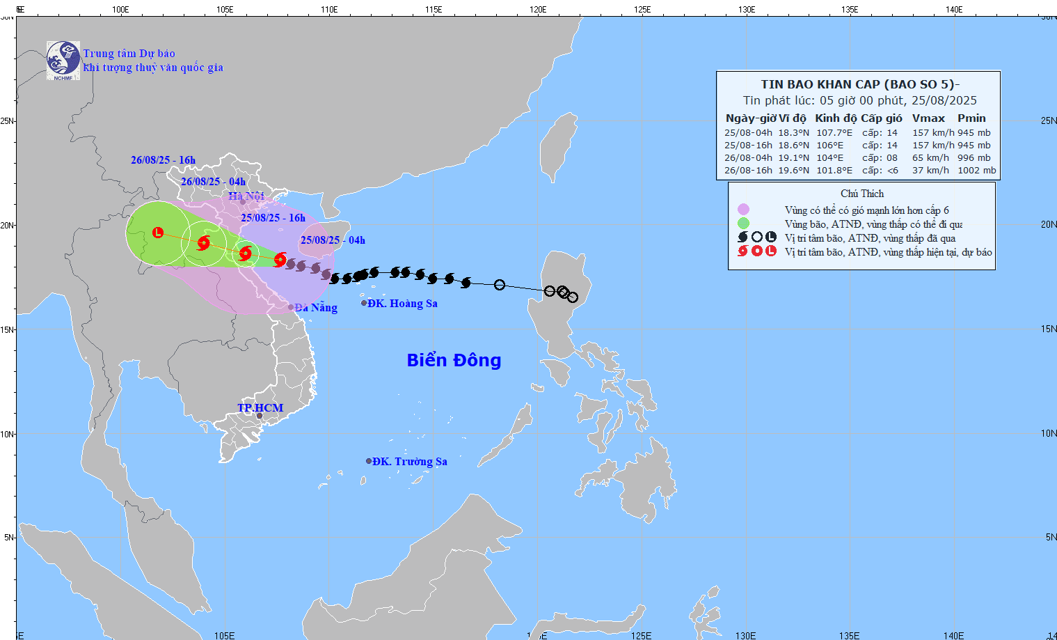
It is forecasted that in 24 hours, the storm will continue to move west-northwest, at a speed of about 20km/h.
At 4:00 a.m. on August 26, the center of the storm was at about 19.1 degrees north latitude - 104 degrees east longitude, in the Central Laos area. The strongest wind is level 8, gusting to level 11.
The danger zone is located between latitudes 16.5 to 20.5 degrees north latitude, west of 108.5 degrees east longitude. Natural disaster risk level: level 3 in the North of the Gulf of Tonkin and the sea area from Thanh Hoa to Quang Tri (including Hon Ngu island, Con Co special zone); level 4 in the coastal waters from Thanh Hoa to Quang Tri, mainland provinces from Thanh Hoa to northern Quang Tri.
It is forecasted that in the next 36 hours, the storm will move west-northwest at a speed of 15-20km/h and gradually weaken.
At 4:00 p.m. on August 26, the center of the low pressure area was at about 19.6 degrees north latitude - 101.8 degrees east longitude, in the Central Laos area. The strongest wind is below level 6.
Thanh Hoa to Bac Quang Tri has strong winds, gusting to level 12-14
Updated on the forecast of impacts at sea, the western sea area of the North East Sea on August 25 will still have strong winds of level 6-7, gusts of level 9, waves 3-5m high, and rough seas.
Mr. Khiem warned that the sea area from Thanh Hoa to Quang Tri (including Hon Ngu island, Con Co special area) will have strong winds of level 7-9, then increase to level 10-11, the area near the storm center will have level 12-14, gusting to level 17. Waves are 5.0-4.0m high, near the center of the storm 8-10m; rough seas.
The North of the Gulf of Tonkin (including the special areas of Cat Hai, Co To, Van Don) will have strong winds of level 6-7, gusting to level 9; In the south, the North of the Gulf of Tonkin (including the special area of Bach Long Vi) will have strong winds of level 8-9, gusting to level 11; waves 3.0-5.0m high; very rough seas.
Rising water in coastal areas and islands from Hai Phong to North Quang Tri will have storm surge from 0.5-1.8m high, especially Thanh Hoa and Nghe An from 1-1.8m high.
The water level according to the station markers at Hon Dau (Hai Phong) is 3.5-4.0m high, Ba Lat (Ninh Binh) 1.8-2,3m, Sam Son (Thanh Hoa) 3.7-4.2m, Hon Ngu (Nghe An) 3.5-4.0m, Cua Nhuong (Ha Tinh) 2.2-2,3m. The risk of flooding dykes, coastal roads, and river mouths due to rising water and waves during the storm is very high in the afternoon and evening of August 25.
Regarding the situation of strong winds, according to the Director of the Meteorological Agency, from the morning of August 25, on the mainland from Thanh Hoa to North Quang Tri, the wind will gradually increase to level 8-11, gusting to level 12-14.
"In the southern Thanh Hoa - Ha Tinh area, there will be strong winds of level 12-14, gusting to level 15-16" - Mr. Khiem especially noted.
Coastal areas from Quang Ninh to Ninh Binh provinces will have winds gradually increasing to level 6-8, gusting to level 9-10.
According to Mr. Khiem, it is forecasted that from the morning of August 25 to the end of August 26, in the midlands and deltas of the North, Lao Cai and from Thanh Hoa to Thua Thien Hue, there will be widespread heavy rain with common rainfall of 100-150mm, locally over 250mm.
"In the area from Thanh Hoa to North Quang Tri, there will be heavy to very heavy rain with common rainfall of 200-400mm, locally over 700mm. Warning of the risk of heavy rain over 200mm in 3 hours" - Mr. Khiem emphasized.
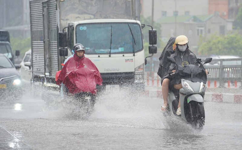
In addition, from August 25 to 26, the Hanoi capital will have moderate rain, heavy rain and thunderstorms. On August 25, Da Nang city had rain, moderate rain and thunderstorms. From August 25 to 26, Ho Chi Minh City will have rain, showers and thunderstorms, concentrated in the afternoon and evening. During thunderstorms, it is necessary to be on guard against the risk of tornadoes and strong gusts of wind.
From the afternoon of August 25 to 27, the Upper and Central Laos regions will have heavy rain with common rainfall of 100-250mm, with some places in the Central Laos region having over 500mm.