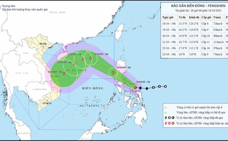
According to the National Center for Hydro-Meteorological Forecasting, at 1:00 a.m. on October 19, the center of the storm was at about 13.7 degrees north latitude; 122.7 degrees east longitude, in the area east of the central Philippines. The strongest wind near the storm center is level 8 (62 - 74 km/h), gusting to level 10. The storm is moving west-northwest at a speed of about 20 km/h.
Storm reaches maximum level 11, gusting to level 13 when reaching Hoang Sa special zone

According to Mr. Mai Van Khiem, Director of the National Center for Hydro-Meteorological Forecasting, this afternoon and evening, October 19, storm Fengshen will pass through Luzon Island (Philippines) and enter the East Sea, becoming storm No. 12.
"It is forecasted that after moving into the East Sea, storm No. 12 will move mainly in the west-northwest direction with increasing intensity, then continue to strengthen" - Mr. Khiem said.
At 1:00 a.m. on October 20, the center of the storm was at about 17.1 degrees north latitude; 118.9 degrees east longitude, in the sea east of the northern East Sea. Strong wind level 9, gust level 11.
The dangerous area in the East Sea in the next 24 hours will be north of the latitude of 15 degrees north; east of the longitude of 117.5 degrees east. The natural disaster risk level is level 3 for the eastern sea area of the northern East Sea.
It is forecasted that in the next 48 hours, the storm will continue to move northwest at a speed of about 20 km/h and is likely to strengthen.
At 1:00 a.m. on October 21, the center of the storm was at about 19 degrees north latitude; 114.8 degrees east longitude, in the eastern sea of the northern East Sea, about 380 km northeast of the Hoang Sa special zone. Strong wind level 10, gust level 13.
The danger zone is north of latitude 15.5 degrees north; east of longitude 113 degrees east. Level 3 natural disaster risk for the northern East Sea area.
It is forecasted that in the next 72 hours, the storm will move west-southwest at a speed of about 10 km/h and is likely to strengthen.
"By around October 22, when the storm moves to the northern area of Hoang Sa special zone, the intensity of storm No. 12 will reach level 11, gusting to level 13" - Mr. Khiem added.
At 1:00 a.m. on October 22, the center of the storm was at about 18.5 degrees north latitude; 113.1 degrees east longitude, in the northern East Sea, about 190 km north-northeast of the Hoang Sa special zone.
The danger zone is north of latitude 17 degrees north; east of longitude 111.5 degrees east. Natural disaster risk level 3 for the northern East Sea area.
Storm likely to weaken when interacting with cold air
In the next 72 to 120 hours, the storm will move mainly southwest, traveling about 10 - 15 km per hour and tend to weaken gradually.
The Director of the meteorological agency said that the characteristics of this storm No. 12 are that when the storm moves into the East Sea, the East Sea is being affected by cold air.
"The cold air mass blocking the western part of the storm makes it unlikely to move westward to enter the North or up to China (due to being blocked in the north and blocked in the west). Therefore, when moving into the Hoang Sa special area, it will reach its strongest intensity of level 11, gusting to level 13, storm No. 12 will be affected by cold air and gradually weaken" - Mr. Khiem analyzed.
Regarding the impact of the storm, according to Mr. Khiem, from October 19, the sea area east of the northern East Sea will have winds gradually increasing to level 6 - 7; the area near the storm center will have strong winds of level 8 - 9, gusts of level 11, waves 2.5 - 5 m high, very rough seas.
From October 20 to 22, the northern East Sea area (including Hoang Sa special zone) is likely to be affected by strong winds of level 10 - 11, gusting to level 13. All ships operating in the above dangerous areas are likely to be affected by thunderstorms, whirlwinds, strong winds and large waves.
"Currently, the rainfall scenarios as well as the impact of storms on the mainland of Vietnam depend heavily on the development of the cold air. Therefore, it is necessary to closely monitor the simultaneous developments of the storm's path and the impact of the cold air" - Mr. Khiem noted.