Storm No. 4 intensity is about level 8, gust level 10
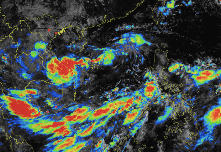
Latest update from the National Center for Hydro-Meteorological Forecasting, at 7:00 a.m. on September 18, the center of the tropical depression was at about 16.7 degrees north latitude; 113.5 degrees east longitude, about 220km east of Hoang Sa archipelago.
The strongest wind near the center of the tropical depression is level 7 (50-61km/h), gusting to level 9; moving mainly west at a speed of about 15km/h.
It is forecasted that in the next 24 hours, the tropical depression will move west-southwest at a speed of about 20km/h, strengthening into a storm.
At 7:00 a.m. on September 19, the center of the storm was at about 16.4 degrees north latitude - 109.2 degrees east longitude, about 210km east southeast of Quang Tri and about 120km east of Da Nang.
The strongest wind near the storm center is level 8, gusting to level 10.
It is forecasted that in the next 48 hours, the storm will move west-northwest at a speed of about 15km/h, make landfall and gradually weaken over the Vietnam - Laos border area.
During the next 48 to 72 hours, the tropical depression will move west-northwest at 10-15km per hour and weaken into a low pressure area.
Tropical depression causes heavy rain in Central Vietnam from September 18
Regarding the impact of the tropical depression, the North East Sea area (including the Hoang Sa archipelago), the sea area from Nghe An to Quang Ngai (including the island districts of Ly Son, Cu Lao Cham, Con Co, Hon Ngu) has strong winds of level 6-7, waves 2-4m high. The area near the storm center has level 8 (62-74km/h), gusts of level 10 (89-102km/h), waves 3-5m high, rough seas.
Ships operating in the above mentioned dangerous areas are likely to be affected by storms, whirlwinds, strong winds and large waves.
Coastal provinces from Quang Binh to Quang Nam need to be on guard against high tides combined with big waves causing landslides of sea dykes, sea embankments, and flooding in low-lying areas.
On land, from early morning and September 19, coastal mainland areas from Ha Tinh to Quang Ngai will have winds gradually increasing to level 6-7, near the storm's eye level 8 (62-74km/h), gusting to level 10 (89-102km/h); deep inland, winds gusting to level 6-7.
From September 18 to September 20, the North and Central Central regions will have heavy to very heavy rain with common rainfall from 100-300mm, locally over 500mm.
From September 18 to September 19, the Central Highlands and the South will have moderate rain, heavy rain and thunderstorms, and locally very heavy rain.


