Typhoon No. 3 Wipha is showing signs of strengthening as it moves deeper into the Gulf of Tonkin, while it has previously weakened. In response to the complicated developments of storm No. 3, on the evening of July 21, Mr. Mai Van Khiem - Director of the National Center for Hydro-Meteorological Forecasting - provided the latest analysis and assessment information about this storm.

The storm intensity when making landfall is level 9 - 10, gusting to level 13
Sir, will there be any notable changes when storm No. 3 enters the Gulf of Tonkin?
- This morning (July 21), the storm passed the northern area of the Lusian Peninsula (China), entering the Gulf of Tonkin; morning intensity level 9.
This change was due to the storm moving north along the mainland late last night as it reached the coast of Guangdong, China, creating friction that reduced the energy source, causing the storm intensity to decrease. When moving into the Gulf of Tonkin, it has decreased by 3 levels, from level 12 to level 9.
As it moves deeper into the Gulf of Tonkin, the storm will strengthen to Category 10 this afternoon and evening. According to current forecasts, this storm may increase in intensity, reaching level 10 - 11, gusting to level 14, when approaching the coastal waters of southern Hai Phong to northern Thanh Hoa.
Currently, in the past 2 hours, the center of the storm has barely moved. The slow movement of the storm poses a potential risk of increasing intensity, and the impact time at sea and on land is even longer.
So with current assessments, when is the forecast for storm No. 3 to make landfall and make landfall in which areas, sir?
- From noon to tomorrow afternoon (September 22), specifically from 10 to 15 hours, the center of the storm will enter the mainland of the provinces from Hai Phong to Northern Thanh Hoa. The storm intensity when making landfall is about level 9 - 10, gusting to level 13.
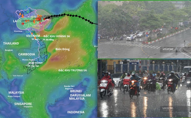
The heaviest rain tonight and tomorrow morning, July 22
Sir, with such a storm, when is the forecast for the heaviest rain and which areas are the focus?
- Regarding heavy rain, the time of heaviest rain caused by storms in the North and North Central regions is from tonight to tomorrow morning, July 22. The rain in the Northeast will last until tomorrow evening, then gradually decrease. In the Northern Delta, Thanh Hoa, Nghe An, rain will continue from tonight to the morning of July 23 due to the storm's circulation.
The focus of rain is the provinces of Hung Yen, Ninh Binh, Nam Phu Tho, Thanh Hoa, Nghe An, generally 200 - 350mm, locally over 600mm. Other places in the Northern region and Ha Tinh will have moderate rain, heavy rain, locally very heavy rain and thunderstorms with common rainfall of 100 - 200mm, locally over 300mm.
Wind in Quang Ninh, Hai Phong level 9 - 10
In fact, when the storm hits, gusts of wind are a particularly dangerous phenomenon. What is the forecast for the wind impact caused by storm No. 3 Wipha, sir?
- Strongest wind in the North and Thanh Hoa. From now until early tomorrow morning, July 21, the coastal area of Quang Ninh will have strong winds of level 9, level 10.
The sea area of the Gulf of Tonkin (including the special areas of Bach Long Vi, Co To, Van Don, Cat Hai, Hon Dau island) will have strong winds of level 6 - 7, then increase to level 8-9, the area near the storm's eye will have levels 10 - 11, gusts of level 14, waves 2-4m high, the area near the storm's eye will have 4-6m, the sea will be very rough.
The southern Gulf of Tonkin (including Hon Ngu Island) has winds gradually increasing to level 6-7, near the storm center level 8-9, gusts of level 11, waves 2-4m high, very rough seas.
From noon to tomorrow afternoon (July 22), the storm's eye will make landfall in the provinces from Hai Phong to Northern Thanh Hoa; Hai Phong coastal area, Hung Yen coastal area (old Thai Binh) will have winds of level 9-10, gusting to level 13-14. Ninh Binh coastal area has winds of level 8-9, gusting to level 13. Thanh Hoa coastal area (concentrated in the North) has winds of level 7-8, gusting to level 8-9. Hanoi will have strong winds of level 5-6, gusting to 7-8 tomorrow afternoon and evening.
Sir, with such a forecast of heavy rain and strong winds, how do you warn about dangerous natural disasters?
- We warn of the risk of heavy rain with rainfall of 150mm/3 hours. Heavy rainfall in a short period of time can cause flash floods, landslides in mountainous areas, and flooding in low-lying areas that are very serious.
It should be noted that landslides are not at the time of the most intense rain, but even after the storm has passed, the risk of landslides at that time is still very high.
When the low pressure area weakens from storm No. 3 moving to Laos, it may continue to cause rain, especially in the mountainous areas west of Thanh Hoa and Nghe An.
Sincerely thank you!
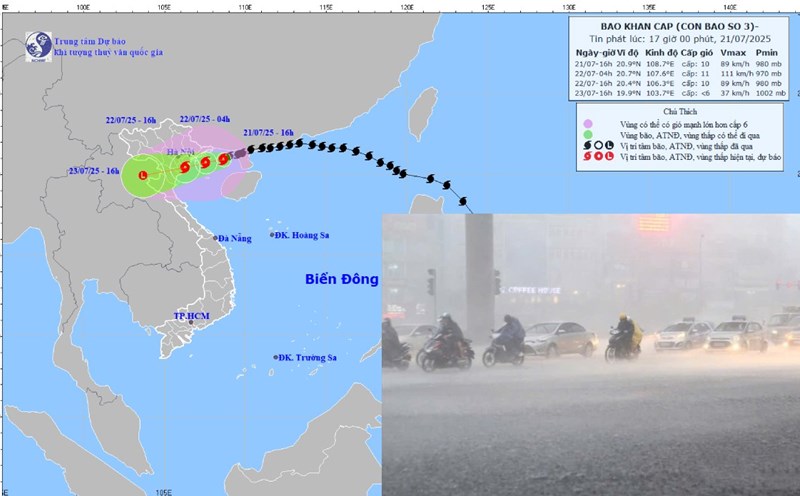
Latest update on storm No. 3 at 7:00 p.m. on September 21:
The storm is only 86km from Quang Ninh
The center of the storm is located at: About 20.9 degrees north latitude; 108.5 degrees east longitude, about 86 km east of Quang Ninh, about 210 km east of Hai Phong, about 230 km east of Hung Yen, about 257 km east-northeast of Ninh Binh.
Maximum wind speed: Level 9-10 (75-102 km/h), gust level 13.
Forecast: In the next 3 hours, the storm will move in a West-Southwest direction, at a speed of about 10 km/h.
At 4:00 a.m. on July 22, the center of the storm was at about 20.7 degrees north latitude; 107.6 degrees east longitude, in the northern Gulf of Tonkin. The strongest wind near the storm center is level 10-11, gusting to level 14.
At 4:00 p.m. on July 22, the center of the storm was at about 20.4 degrees north latitude; 106.3 degrees east longitude, on the mainland of the coastal area from Hai Phong to Thanh Hoa. The strongest wind near the storm center is level 9-10, gusting to level 13.