Hanoi needs to be on guard against unusually strong winds during storms
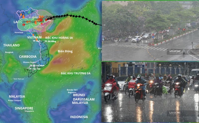
Hanoi is forecast to be one of the localities strongly affected by storm No. 3 Wipha.
On the evening of July 21, Mr. Nguyen Van Hiep - Deputy Director of the Northern Hydrometeorological Station - said that from tomorrow, Hanoi will start to be affected by winds and storms. From noon and afternoon tomorrow, Hanoi is forecast to have strong winds of level 5 - 6, the wind gusts may reach level 7 - 8, beware of strong winds occurring locally.

In addition to the storm wind, Mr. Hiep also warned people to be vigilant against thunderstorms.
"Hanoi is an area with many high-rise buildings, so this area may experience the effect of increased winds, causing these wind waves to increase abnormally" - Mr. Hiep warned.
Regarding the rain situation, Hanoi is forecast to have more rain from this evening and tonight. Mr. Hiep said that the forecast for tomorrow's rainfall in Hanoi will be from 100 - 200mm, some places over 300mm. Beware of localized rain and thunderstorms. Due to the impact of heavy rain, many areas in the capital need to be on guard against the risk of flooding. In the inner city area, it is forecasted to be flooded 0.2 - 0.5m, locally flooding for about 30 minutes - 1 hour.
"Regarding floods on rivers, currently, the water level on rivers is not too high, below alert level 1. With common rainfall from 100 - 200mm, Mr. Hiep predicted that floods on rivers will mainly reach alert level 1, some places will exceed alert level 2. In addition, it is necessary to be on guard against landslides in some communes and wards in the suburbs of Hanoi or low-lying areas along the river" - Mr. Hiep added.
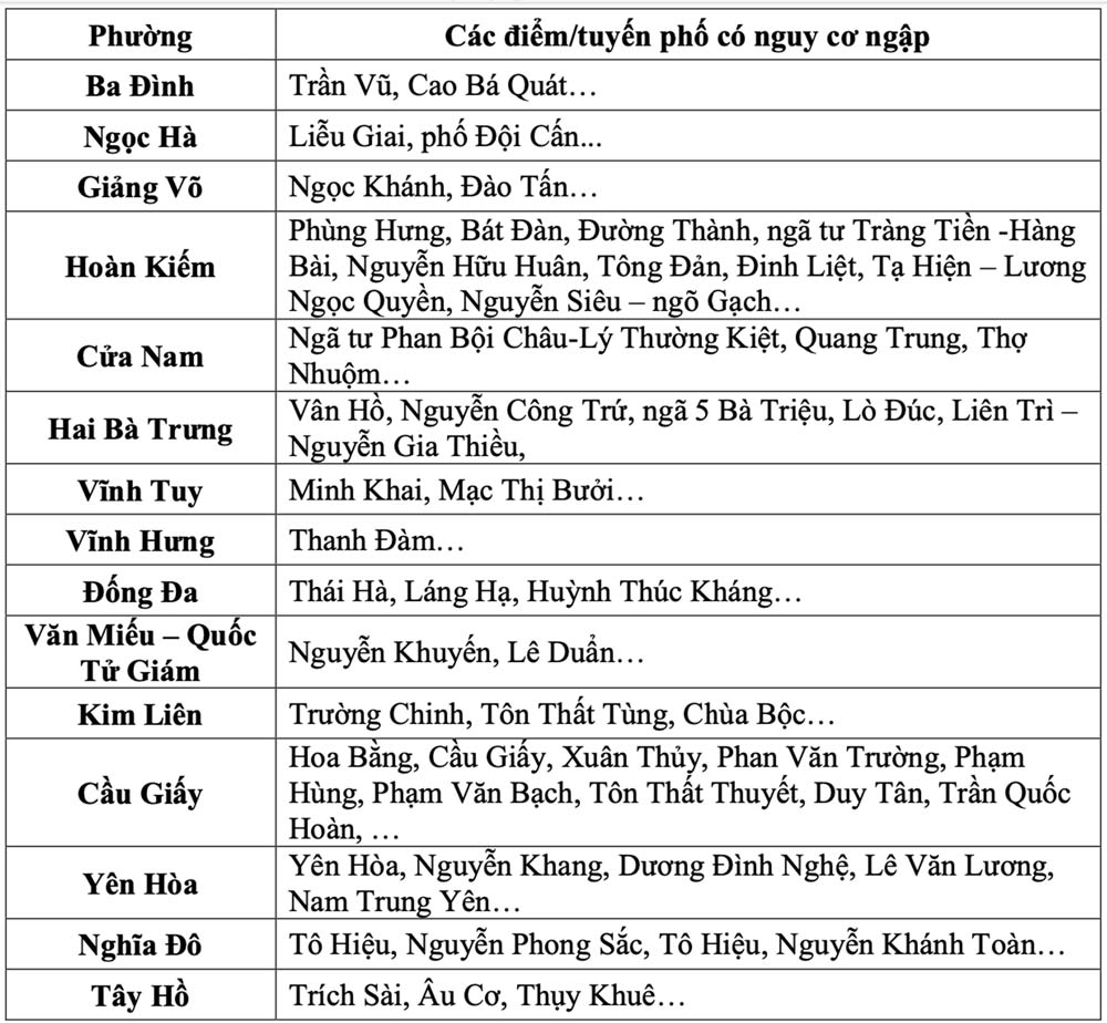
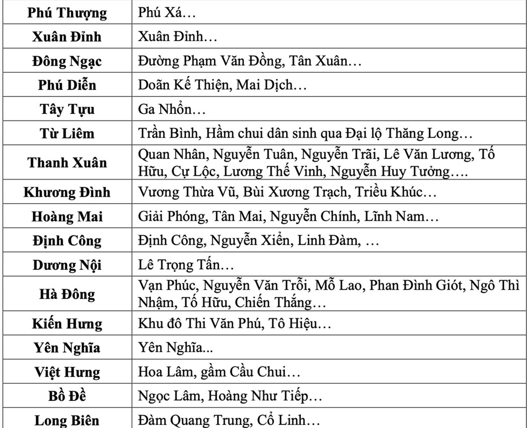
Warning of flood risk in Hanoi
At 7:30 p.m. on July 21, the Northern Hydrometeorological Station issued the latest warning about flooding in Hanoi.
Accordingly, in the next 3-6 hours, Hanoi and neighboring areas will continue to have moderate to heavy rain, with total accumulated rainfall generally ranging from 30-50mm, in some places higher.
This rain will cause localized flooding for many streets with the largest common flooding depth of 0.1-0.3m, some places will be flooded deeper; the flooding time is about 20-30 minutes, some places will be flooded longer. Prevent flooding in some low-lying areas in suburban areas.
The Northern Hydrometeorological Agency warns that the risk of natural disasters due to flooding is level 1. Heavy rain is likely to cause flooding on some streets, affecting vehicles participating in traffic. In addition, it is necessary to be on guard against landslides in some communes and wards in suburban areas of Hanoi such as Ba Vi, Son Tay...
Regarding the hydrological situation in Hanoi, currently, the water level on the Da River, Red River, Duong River is decreasing; the water level on the Day River, small rivers, and intra-provincial rivers such as the Bui River, Tich River, Ca Lo River... is changing slowly, generally below alert level 1.
However, from this afternoon (July 21) to July 25, it is forecasted that there will be a flood on the rivers in Hanoi with a water amplitude of 1.5 - 3.5m. During this period, the flood peak on the Da, Red, and Duong rivers is likely to be below alert level 1; the Day, Bui, Tich, and Ca Lo rivers may rise to alert level 1 - alert level 2, some places above alert level 2.
High river water levels can cause flooding and landslides in low-lying areas and along rivers. Risk of flooding in many inner-city streets of Hanoi, with a flooding depth of 0.2 - 0.5m, some places over 0.5m. The expected flooding time is from 30 - 60 minutes, some areas may be flooded for a long time.
The warning level of natural disaster risk due to floods is level 1. Areas at high risk of landslides and flooding include communes/wards: Xuan Mai, Quang Bi, Tran Phu, Chuong My, Dan Phuong, My Duc, Thanh Oai, Hoa Xa, Van Dinh...
Floods, inundation, flash floods and landslides can affect people's lives, causing damage to aquaculture areas, agricultural production areas, industrial parks, transportation and daily life. People need to closely monitor flood developments and proactively prevent them.