New storm forms after Francine sweeps across US

Thanh Hà |

Fox News' latest storm report says the latest storm, Gordon, formed in the eastern Atlantic on September 13.

Hurricane Gordon strengthened from Tropical Depression 7, one of several systems the US National Hurricane Center (NHC) is monitoring in the Atlantic Ocean.

According to the latest storm information, Hurricane Gordon is approximately 1,600 km from the Cape Verde Islands. The storm's maximum sustained winds are 65 km/h.

The latest hurricane forecast from the US National Hurricane Center says that over the next few days, Hurricane Gordon is expected to move across the open waters of the Atlantic Ocean.

Hurricane Gordon is currently moving west-northwest and is expected to slow but continue this direction for the next few days.

"The official forecast currently considers Gordon to remain a tropical storm for the entire forecast period," the NHC storm bulletin said. Gordon is not expected to have any impact on weather in the United States.

Con bao moi nhat Gordon la con bao so 7 trong mua bao Dai Tay Duong 2024. Anh: Fox Weather
The latest storm, Gordon, is the seventh storm of the 2024 Atlantic hurricane season. Photo: Fox Weather

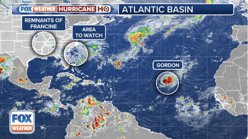
According to USA Today's latest hurricane report, in addition to Gordon, hurricane forecasters are also monitoring an area of ​​low pressure closer to the United States, just off the southeastern coast of the United States.

The latest forecast from the National Hurricane Center says the system could become a tropical depression early next week as it moves north or northwest. If it becomes a hurricane, it will be called Helene.

In addition to the low pressure area that has the potential to strengthen into Hurricane Helene, another low pressure area is also forming in the Atlantic Ocean but the possibility of strengthening is almost 0%.

The latest storm of the 2024 Atlantic hurricane season, Gordon, formed after Hurricane Francine made landfall about 60 miles southwest of New Orleans this week, bringing strong winds to coastal areas. Wind gusts of 78 mph were recorded in New Orleans. Up to 8 inches (200 mm) of rain fell there, causing flooding in many areas.

More than 100,000 customers in Louisiana remain without power due to the impact of Hurricane Francine. Flood warnings remain in effect in Middle Tennessee and most of Alabama due to heavy rains from Hurricane Francine.

The impact of Atlantic Hurricane No. 6 on the Lower Mississippi Valley is expected to end on September 14 when the storm's circulation dissipates.

Thanh Hà
RELATED NEWS

Energy source causes storm number 6 Francine to rapidly increase in intensity

|

Hurricane Francine is picking up speed and is expected to become a hurricane today.

New Year's Eve is approaching, people are still rushing on their way home

|

HUE - Just a few hours before the New Year's Eve of Binh Ngo 2026, at Hue train station, people are still rushing back to their hometowns, hoping to reunite with their families in time.

Russia is considering aid options for Cuba

|

The Russian Ambassador said that contact is taking place both directly and through the Russian Embassy in Havana and the Cuban Embassy in Moscow.

On the afternoon of the 29th of Tet, Hanoians jostle to buy New Year's Eve feasts at the "rich market"

|

Hanoi - Hang Be traditional market at its peak on the 29th of Tet attracts many people to buy food, worship ceremonies, and prepare for the New Year's Eve offering tray.

Workers reflect not being on the list of Tet bonuses

|

Workers reflect that while others received Tet bonuses, they did not receive them and have not received an official notice from the company.

Hue New Year's Eve quietly preserves ancient rituals

|

HUE - In the middle of New Year's Eve, the offering tray outside the yard is still preserved, solemn and imbued with traditional values.

Damaged road surface on Dai Ninh Pass completed

|

Lam Dong - The damaged road surface section on the top of Dai Ninh Pass (National Highway 28B) has been repaired, ensuring safe traffic for vehicles during the Tet peak.

Tan Son Nhat airport cools down on the 29th of Tet, serving nearly 120,000 passengers

|

Ho Chi Minh City - After a series of peak days with more than 150,000 passengers/day, the passenger volume through Tan Son Nhat airport on the 29th of Tet has begun to decrease.

Dự báo bão mới xuất hiện khi Francine đe dọa gây lũ lụt ở Mỹ

Thanh Hà |

Bão Francine đã suy yếu thành áp thấp nhiệt đới. Trong khi đó, một áp thấp khác dự báo mạnh lên thành bão số 7 Gordon trong ngày 13.9.

Bão Francine tăng cấp khiến 400.000 gia đình ở Mỹ mất điện

Thanh Hà |

Dự báo, khi bão số 6 Francine di chuyển xa hơn về phía bắc, tình trạng mất điện tiếp tục tăng ở Mỹ.

Energy source causes storm number 6 Francine to rapidly increase in intensity

Thanh Hà |

Hurricane Francine is picking up speed and is expected to become a hurricane today.