According to the latest storm report from CNN, Hurricane Francine has weakened from a Category 2 storm to a tropical depression since the morning of September 12, but is still posing a serious flood threat to the southern United States, with heavy rains leading to flood warnings for more than 10 million people. Heavy rain is forecast to continue in the southeastern part of the United States throughout September 13. Up to 200 mm of rain could cause flooding in this area.
CNN notes that as the storm slows down, it will linger longer in areas along its path, exacerbating the risk of flooding. Rain-induced flooding has become the deadliest threat to tropical systems over the past decade.
Hundreds of structures were flooded by Hurricane Francine, the sixth storm of the Atlantic hurricane season. Francesca Holt Blanchard, a spokeswoman for Louisiana's St. Charles Parish, said flooding was reported at 350 structures in the parish. In neighboring Jefferson Parish, more than 50 homes in the city of Kenner were flooded by the storm.
Flood emergencies and rescues have been declared as Hurricane Francine brought more than a month’s worth of rain to New Orleans in just a few hours. According to the National Weather Service, 6-8 inches (150-200 mm) of rain fell in the area, prompting flash flood warnings to begin overnight on September 11. Heavy rains flooded roads and cut off travel routes in several parishes. Lafourche Parish in Louisiana had to rescue 26 residents trapped in flooded homes overnight on September 11.
Power outages had reached 450,000 homes and businesses in Louisiana by the morning of September 12. As restoration efforts continued, nearly 150,000 homes and businesses remained without power overnight, according to PowerOutage.us. Power outages were also reported in Mississippi and Alabama as high winds and heavy rain from the latest storm, Francine, hit the region.
According to CNN's storm report, Hurricane Francine is now a tropical depression and is expected to dissipate completely by the end of the week. However, flooding still poses a significant threat to the southeastern United States on September 13.
Flood warnings remain in effect for about 8 million people across Tennessee, Alabama, Mississippi and Georgia, according to the latest forecast from the Weather Prediction Center. The warnings are scheduled to expire late Tuesday and into Friday. The heaviest rainfall is expected overnight across central Alabama, with up to 5-10 inches (130-250 mm) forecast across Arkansas, Kentucky and Georgia.
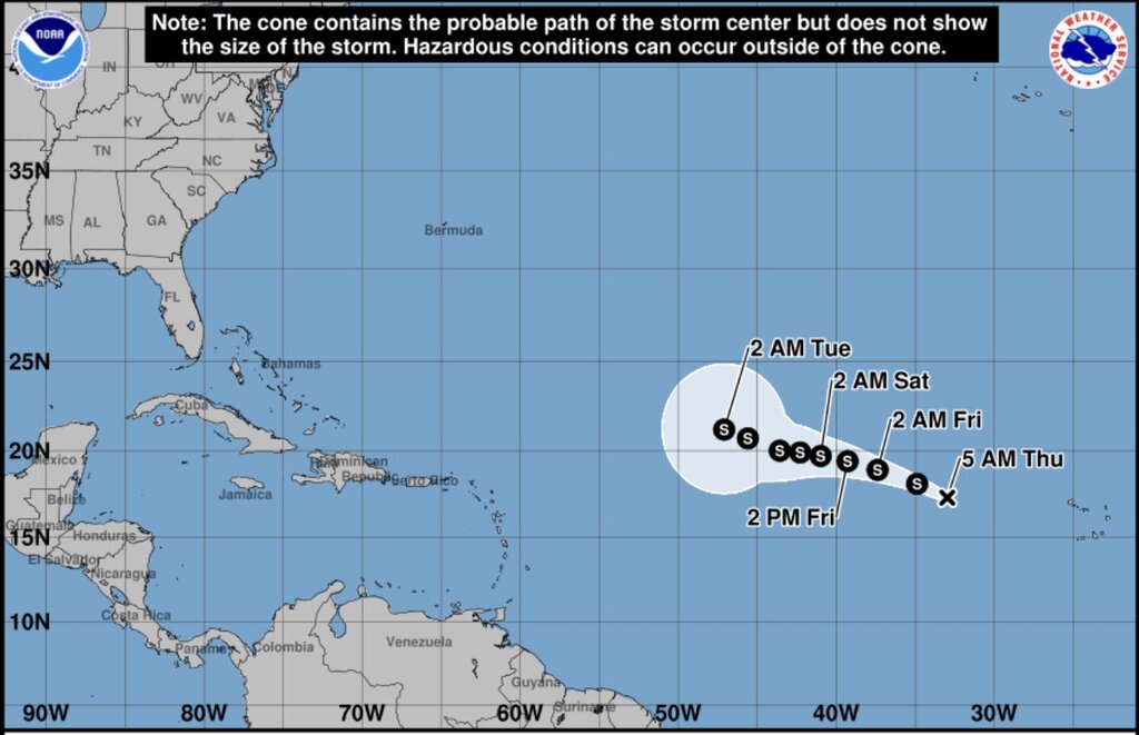
Following Hurricane No. 6, the US National Hurricane Center is monitoring 1 tropical depression, 1 low pressure area and 1 low pressure system off the coast of Florida. Of these, the low pressure system off the coast of Florida is currently at low potential for strengthening this week and is forecast to strengthen next week. The low pressure area a few hundred kilometers east of the Leeward Islands currently has a 30% chance of strengthening. The furthest system, Tropical Depression No. 7 in the central Atlantic, formed on September 11.
The latest storm and low pressure forecast says this low pressure will have several phases of strengthening and will strengthen into tropical storm Gordon on September 13.