The latest storm news on the morning of January 17th from the Philippine Atmospheric, Geophysical and Astronomical Services Agency (PAGASA) said that Typhoon Nokaen continues to strengthen and is approaching the intensity of a strong tropical storm, with winds of 85 km/h and gusts up to 105 km/h.
At 10 am on January 17, the storm was 75km east of Virac, Catanduanes, with winds of 85 km/h, gusts of 115 km/h. The storm moved northwest at a speed of 25 km/h.
Previously, at 4 am on the same day, the storm was 175km east of Juban, Sorsogon and was moving west-northwest at a speed of 20 km/h.
PAGASA's Category 2 storm warning is maintained in the following areas: eastern Camarines Sur, Catanduanes, Albay, Sorsogon, Northern Samar, northeast Samar, northeast Samar.
Meanwhile, level 1 storm warnings were issued in areas east of Quezon, including the Polillo, Marinduque, Camarines Norte archipelagos, the remaining areas of Camarines Sur, Masbate, the remaining areas of Eastern Samar, Samar, Biliran, Leyte, Southern Leyte, northern Cebu along with Bantayan and Camotes, Dinagat archipelagos.
Philippine weather forecasters said that the possibility of Typhoon Ada strengthening into a severe tropical storm has not been ruled out. The storm may sweep through Catanduanes from the afternoon of January 17 to the morning of January 18.
After that, the storm may move erratically in an arc from January 18 and weaken continuously due to dry air entering the storm center.
It is forecast that Typhoon Nokaen will continue to cause significant rain for the Eastern Visayas region, Bicol region and Quezon province.
On January 17, Catanduanes forecast recorded very heavy rain, while Northern Samar and most of the Bicol region are likely to experience heavy to very heavy rain.
Widespread floods and landslides are threatening these areas. In addition, mudslides may also occur along the Mayon volcano slope.
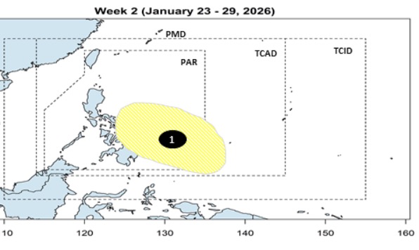
Meanwhile, PAGASA's typhoon and low pressure forecast on January 16th stated that after Typhoon Nokaen affected the Philippines throughout the week from January 16th to January 22nd, a new low pressure was forecast to form near the Philippines in the week from January 23rd to January 29th.
The low pressure right after Typhoon Nokaen is expected to form at the southeast boundary of PAGASA's PAR and TCAD forecast areas. It is expected that the new low pressure will move towards the Caraga area, Eastern Visayas of the Philippines. However, this low pressure is unlikely to strengthen into a typhoon.


