Low pressure near the East Sea is likely to strengthen into a storm

Thanh Hà |

It is forecast that the storm will form from a low pressure area near the East Sea in the coming days and is likely to affect the mainland.

Latest storm and low pressure news on January 10th from the Philippine Atmospheric, Geophysical and Astronomical Services Agency (PAGASA) in the Visayas region, Philippines warns about the possibility of rain during the upcoming Sinulog festival.

Sinulog Festival is an annual cultural and religious event held on the 3rd Sunday of January in Cebu, Philippines.

PAGASA's weather forecaster in Visayas, Jomer Eclarino, said heavy rain affected some areas on January 4 and 5 due to breaks in wind. Breaks in wind also caused flash floods and landslides in some areas.

Windbreaks are the convergence of northeast monsoon and hot and humid air from the eastern Pacific Ocean.

Until the morning of January 10, PAGASA did not monitor any low pressure areas near the Philippines that were likely to strengthen into storms or tropical depressions.

According to PAGASA's latest storm forecast, from now until January 22, a low pressure area is likely to form in the east of the Philippines.

A new low pressure area is likely to form at the eastern boundary of PAGASA's TCAD forecast area.

Philippine weather forecasters said that this low pressure area is expected to enter PAR and head east of Mindanao - east of Visayas, Philippines. It is likely that this system will strengthen into a storm or tropical depression at a low to moderate level from now until January 15.

Ap thap gan Bien Dong du bao co kha nang manh len thanh bao trong nhung ngay toi. Anh: PAGASA
Low pressure near the East Sea is forecast to strengthen into a storm in the coming days. Photo: PAGASA

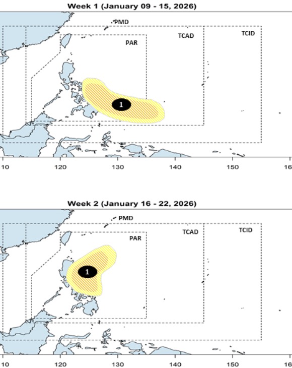
This low pressure area is forecast to continue to operate near the Philippines in the week from January 16 to January 22. During the forecast period, this low pressure area with potential to strengthen into a storm will move closer to the east of Southern Luzon. Similar to the previous week, forecasters believe that this system is likely to strengthen into a storm or tropical depression at a level from low to medium.

In the previous forecast, PAGASA stated that from January 12 to January 18, 2 low pressures are likely to form in the forecast area, with 1 low pressure at the southern boundary of PAR while the 2nd low pressure forms near the south of Palawan.

It is highly likely to rain on January 18 during the Sinulog 2026 festival" - Mr. Eclarino said.

The Philippine forecaster added that rainfall will depend on the duration of the low pressure near the Philippines.

Mr. Eclarino also said that the Central Visayas region is forecast to be cloudy to foggy with scattered showers or thunderstorms until January 11. The expected temperature ranges from 25 to 31 degrees Celsius.

Thanh Hà
RELATED NEWS

La Nina forecasts rapid retreat, paving the way for El Nino to arrive early

|

La Nina may end soon, helping El Nino to form quickly, likely to appear in the summer of 2026.

Forecast of 2 consecutive low pressures around the East Sea

|

Two new low pressure areas are forecast to appear in the East Sea and near the East Sea.

New low pressure area forecast to cause continuous rain

|

The new low pressure area in the East Sea is named 01a by the Philippines.

Fansipan white with snow and ice during severe cold spell

|

Lao Cai - Fansipan peak is submerged in ice when the temperature drops to about 0 degrees Celsius.

Nearly 500 billion VND reservoir rescue plan from Japanese experts

|

Lam Dong - Functional agencies have consulted Japanese experts to complete the plan to overcome the Dong Thanh reservoir project.

Chain collision in Hanoi kills one person

|

Hanoi - One person died, many vehicles were damaged after a chain traffic accident on Nga Tu Vong overpass, morning of January 10.

Hai Phong authorities intervene after reflecting strange odor in domestic water

|

Hai Phong - Many households in Kien Minh commune reflect on social networks about the situation of domestic water showing signs of not ensuring quality...

It's a bit of a bit of a bit of a bit of a bit of a bit.

Reasons why Ho Chi Minh City is experiencing a special cold spell

|

Talking to Lao Dong Newspaper, Mr. Tran Van Hung - Deputy Director of the Southern Hydrometeorological Station said that the temperature in Ho Chi Minh City dropped sharply due to increased cold air.

La Nina forecasts rapid retreat, paving the way for El Nino to arrive early

Thanh Hà |

La Nina may end soon, helping El Nino to form quickly, likely to appear in the summer of 2026.

Forecast of 2 consecutive low pressures around the East Sea

Thanh Hà |

Two new low pressure areas are forecast to appear in the East Sea and near the East Sea.

New low pressure area forecast to cause continuous rain

Thanh Hà |

The new low pressure area in the East Sea is named 01a by the Philippines.