The latest storm information from the Philippine Atmospheric, Geophysical and Astronomical Services Administration (PAGASA) said that the storm will continue to strengthen as it moves west-northwest over the East Sea.
The center of the storm at 4:00 a.m. on November 26 was at 11.9 degrees north latitude, 119.0 degrees east longitude, 130km west of Coron, Palawan, Philippines, and about 540km east of Song Tu Tay Island.
Maximum winds near the center of the storm are 85 km/h, gusting up to 105 km/h and central pressure 992 hPa.
The storm is moving west-northwest at a speed of 25 km/h. The storm-force wind radius extends up to 300km from the center of the storm.
The storm made its seventh landfall in Linapacan, Palawan, Philippines, at 22:50 on the night of November 25, before moving out of the area.
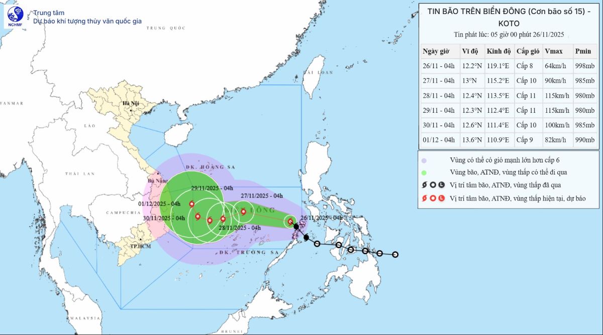
The storm forecast of the Vietnam National Center for Hydro-Meteorological Forecasting said that currently, storm No. 15 is still in the process of intensification, the maximum intensity can reach level 11, gusting to level 14.
By 4:00 a.m. on November 27, storm No. 15 moved west-northwest, at a speed of 15-20km/h in the central East Sea, about 200km north-northeast of Song Tu Tay Island, and is likely to strengthen.
The strongest wind near the storm center is level 10, gusting to level 13. Level 3 natural disaster risk warning for the central East Sea area (including the northern sea area of Truong Sa).
It is forecasted that by 4:00 a.m. on November 28, storm No. 15 will change direction, moving west-southwest, at a speed of 5-10km/h in the central East Sea, about 150km north-northeast of Song Tu Tay Island, and is likely to strengthen.
The strongest wind near the storm center is level 11, gusting to level 14. Level 3 natural disaster risk warning for the central East Sea area (including the sea area north of Truong Sa area).
At 4:00 a.m. on November 29, storm No. 15 is forecast to move westward at a speed of about 5km/h in the western sea area of the central East Sea, about 250km west-northwest of Song Tu Tay Island.
The strongest wind near the storm center is level 11, gusting to level 14. Level 3 natural disaster risk warning for the central East Sea area (including the northern sea area of Truong Sa).
From the next 72 to 120 hours, storm No. 15 will move northwest, at a speed of about 5km/h and gradually weaken.
Storm forecast models all give storm No. 15 the strongest on November 27 when it is in the central area of the southern East Sea. Continuing towards Vietnam, a cold air mass from the north overflowed, causing the sea to lose heat and weaken. At this time, the storm will continuously change direction. Currently, there is an 80% probability that the storm will turn north at about 112 degrees east longitude.
Due to the influence of the storm, the central East Sea area (including the sea area north of Truong Sa special zone) has strong winds of level 6-7; the area near the storm's center has strong winds of level 8-10, gusts of level 13. waves 4.0-6.0m high, the area near the storm's center has 6.0 8.0 8.0m; the sea is very rough.
During the period of November 27-28, the central East Sea area (including the northern sea area of Truong Sa special zone) is likely to be affected by strong winds of level 11, gusts of level 14, waves 7.0 9.0m high, and rough seas.
Regarding cold air, on the night of November 25, cold air continues to affect the North Central and Central Central regions, no rain, cold at night and in the morning, some places in the mountainous areas of the North are very cold.
The lowest temperature in this cold air mass in the Northern and North Central regions will generally be from 12-15 degrees Celsius, in the mountainous areas of the North 10-12 degrees Celsius, and in the high mountains below 10 degrees.
Weather forecast for Hanoi area on the day and night of November 26: Lowest temperature 12-14 degrees Celsius, highest temperature: 23-25 degrees Celsius. Few clouds, sunny day, no rain at night. Northeast wind level 3. Cold in the morning and night.


