Tropical depression before storm No. 15 makes landfall with 4m waves, accelerates to the East Sea

Khánh Minh |

Tropical depression Verbena - the predecessor of storm No. 15 - made landfall in Bayabas, Surigao del Sur, Philippines at 1:30 p.m. on November 24.

Tropical depression Verbena, with its strongest winds of 45 km/h near the center and gusts of 55 km/h, is posing an immediate and increasing threat to people across Visayas and key areas in Luzon and Mindanao in the Philippines.

At 2:00 p.m. on November 24, the center of the tropical depression was at 9.0 degrees north latitude, 126.1 degrees east longitude, with the strongest winds of 45 km/h, gusting to 75 km/h, continuing to move rapidly west-northwest at a speed of 30 km/h, with strong winds spreading up to 200 km from the center of the tropical depression.

The Philippine Atmospheric, Geophysical and Astronomical Services Administration (PAGASA) has issued a tropical storm wind signal (TCWS) level 1 for a large area, giving a 36-hour warning for strong winds of 39 to 61 km/h (level 6-7).

This means that threats from small to large for life and property could occur across all areas of the TCWS, including a significant part of the country: Luzon, Visayas, Mindanao.

In addition to the direct threat from the circulation of tropical depression Verbena, the increase in the northeast monsoon will be combined with a low pressure that causes strong gusts in areas that have not yet had any wind warning, including almost all of Luzon and Visayas today and tomorrow, expanding to some areas of Mindanao, such as Surigao del Sur, Misamis Oriental and Zamboanga del Norte.

The move at sea is warned to be "dangerous to all types of heavy-duty vessels" due to rough seas (waves up to 4.5m high) in the Batanes sea area.

Strong seas (waves up to 4.0m high) are also forecast in the waters of Ilocos Norte, Ilocos Sur and the waters west of Pangasinan.

The Verbena is forecast to move mainly west-northwest from now until tomorrow (November 15).

Verbena will continue to accelerate through Visayas and northern Palawan on the evening of November 24 and the evening of November 25, before entering the East Sea around the morning of November 26.

PAGASA warned that heavy rains and strong winds could still occur in areas outside direct landfall points and narrow forecast areas.

Tropical depression Verbena may reach tropical storm strength before reaching northern Palawan or after entering the East Sea, becoming storm No. 15.

The storm could reach its peak as a severe tropical storm as it enters the central East Sea.

According to the storm forecast bulletin at 2:00 p.m. on November 24 of the Vietnam National Center for Hydro-Meteorological Forecasting, from the evening of November 25, the eastern sea area of the central and southern East Sea will have winds gradually increasing to level 6-7; the area near the storm center will have strong winds of level 8, gusts of level 10, waves 3.0-5.0m high. Strong seas.

Du bao duong di cua ap thap nhiet doi gan Bien Dong. Anh: Trung tam Du bao Khi tuong Thuy van Quoc gia Viet Nam
Forecast of the path of the tropical depression near the East Sea. Photo: Vietnam National Center for Hydro-Meteorological Forecasting

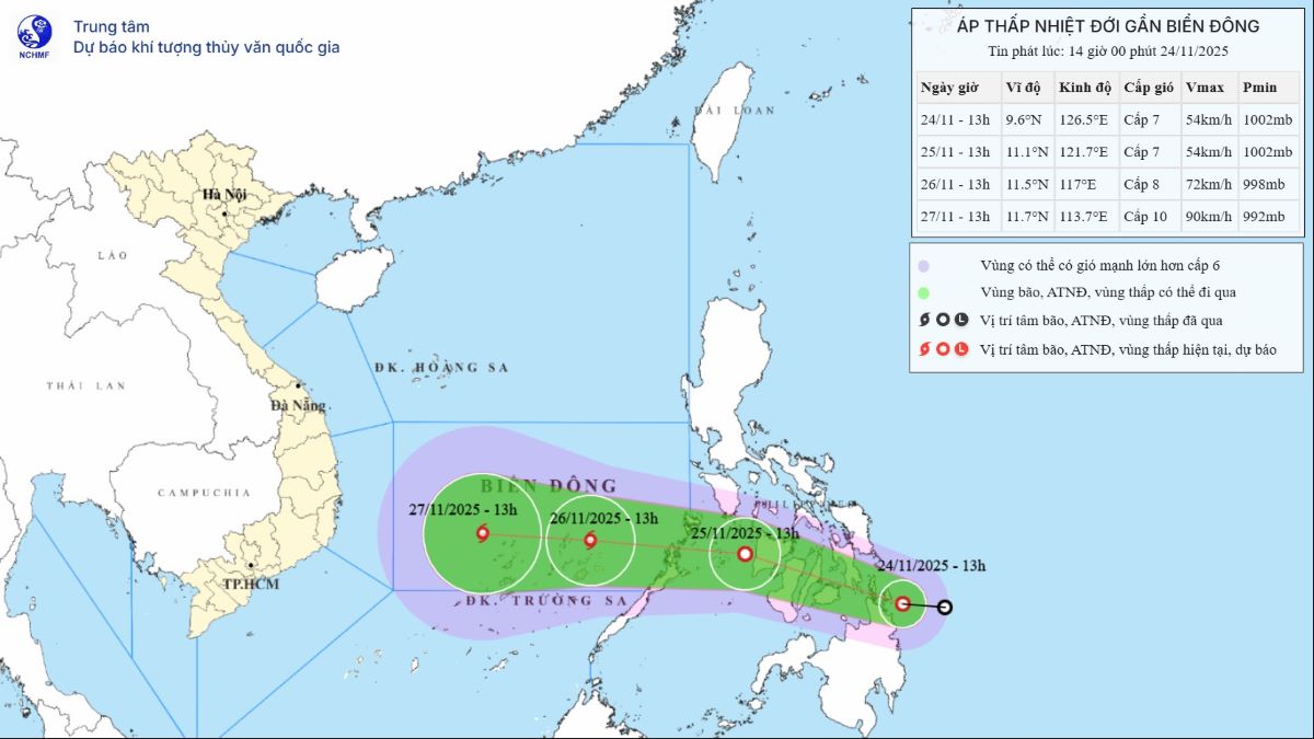
Warning: Around the night of November 26-28, the central and southern East Sea (including the northern sea area of Truong Sa special zone) is likely to be affected by strong winds of level 9-10, gusting to level 13.

Ship operating in the above-mentioned dangerous areas are likely to be affected by thunderstorms, whirlwinds, strong winds, and large waves.

Khánh Minh
RELATED NEWS

Warning of storm No. 15 that could bring heavy rain and floods to many areas

|

Storm No. 15 is forecast to bring flood danger to areas still in disarray after previous storms.

Forecast of the most affected area of storm No. 15 with potential heavy rain and flooding

|

The low pressure in the Philippines is expected to strengthen into storm Verbena, entering the East Sea in the middle of next week, becoming storm No. 15.

Warning of potential risk of storm No. 15 sweeping back into the eye of storm No. 13

|

The new low pressure in eastern Mindanao is likely to become storm No. 15 and enter the correct trajectory of storm No. 13 Kalmaegi that devastated the Philippines.

Hanoi plans to spend 1,985 billion VND in additional income for cadres, civil servants and public employees in 2025

|

The Hanoi People's Committee submitted to the People's Council a draft Resolution on paying additional income to cadres, civil servants and public employees from the basic salary fund and reforming outstanding salaries.

The case of a teacher fighting with a principal at a drinking party: With the participation of a prestigious person

|

Lao Cai - Tram Tau Commune Police verified and clarified the incident of a teacher fighting with a principal at a party celebrating Vietnamese Teachers' Day.

Land crack extends over 700m, Lam Dong continues to urgently evacuate 30 households

|

Lam Dong - A complex cracks in the soil stretched for hundreds of meters on a hill in D'ran commune, forcing the locality to urgently evacuate 30 households to ensure safety.

Will minimize the time to issue construction permits

|

Deputy Minister Bui Xuan Dung said that the maximum time to issue a construction permit will be reduced (the maximum permit issuance period is expected to be 7 - 10 days).

The trade union provides emergency support of more than 1.5 billion VND to help Gia Lai workers recover from storms and floods

|

Gia Lai - The Vietnam General Confederation of Labor and local labor federations supported more than 1.5 billion VND for union members and workers in the province, helping them recover soon after the double natural disaster.

Warning of storm No. 15 that could bring heavy rain and floods to many areas

Khánh Minh |

Storm No. 15 is forecast to bring flood danger to areas still in disarray after previous storms.

Forecast of the most affected area of storm No. 15 with potential heavy rain and flooding

Khánh Minh |

The low pressure in the Philippines is expected to strengthen into storm Verbena, entering the East Sea in the middle of next week, becoming storm No. 15.

Warning of potential risk of storm No. 15 sweeping back into the eye of storm No. 13

Song Minh |

The new low pressure in eastern Mindanao is likely to become storm No. 15 and enter the correct trajectory of storm No. 13 Kalmaegi that devastated the Philippines.