The latest storm/low pressure information from the Philippine Atmospheric, Geophysical and Astronomical Services Administration (PAGASA) said that the tropical depression near the East Sea Verbena is still maintaining its strength as it moves northwest towards Negros Island.
The center of the tropical depression at 4:00 a.m. on November 25 was at 10.3 degrees north latitude, 123.5 degrees east longitude, in the coastal waters of Pinamungahan, Philippines.
Maximum wind speed is 55 km/h, gusting up to 90 km/h and central pressure is 998 hPa.
The tropical depression is moving northwest at a speed of 25 km/h.
The range of tropical cyclone winds is up to 200km from the center of the tropical depression.
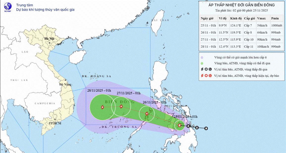
Meanwhile, according to the Vietnam National Center for Hydro-Meteorological Forecasting (NCHMF), by 1:00 a.m. on November 26, the tropical depression is likely to strengthen into a level 8 storm, gusting to level 10, entering the East Sea at coordinates 11.5 degrees north latitude, 119.5 degrees east longitude; in the southeastern sea area of the central East Sea. The storm is moving west-northwest at about 20-25 km/h.
When it has entered the East Sea and become storm No. 15, it is forecasted that storm No. 15 will likely strengthen, level 9-10, gust level 12.
It is forecasted that by 1:00 a.m. on November 27, the center of the storm will be at 12.5 degrees north latitude, 115.9 degrees east longitude; in the central East Sea, moving west-northwest, about 15-20 km/h.
NCHMF's forecast coincides with PAGASA's storm forecast as the Philippine Meteorological Agency forecasts that Typhoon No. 15 will strengthen into a severe tropical storm on November 27 and 28. However, PAGASA forecasts that by the morning of November 29, the storm will weaken to a tropical storm when it is about 300km from Nha Trang.
Currently, although it is only a tropical depression, Verbena is forecast to bring heavy rains across Cebu (Philippines) - enough to cause flooding and landslides.
PAGASA said the Verbena could bring between 100-200mm of rain, which is considered hazardous due to the province's current silted land and waterway conditions.
Mr. Al Quiblat, Head of Weather Forecasting Department of PAGASA Visayas, said that heavy rain poses a greater threat than the wind power of the tropical depression. What people need to monitor is the likelihood of flash floods, inundation and landslides, especially in areas that have been weakened by previous weather disturbances, he said.
The city of Cebu has raised its natural disaster warning to a red alert as many weather systems converge in the Visayas region, leading to an urgent warning of heavy rain and flooding risks.
The most dangerous hours according to PAGASA's forecast will be from 10pm on November 25 to 3am on November 26.


