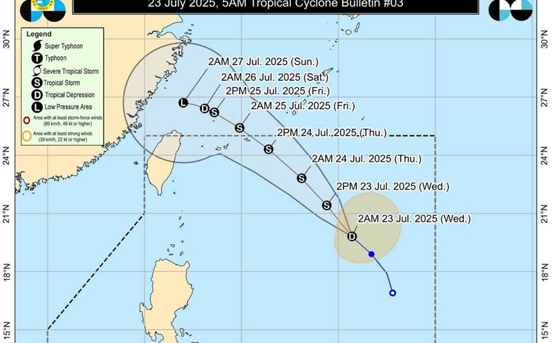
The latest storm information from the Philippine Atmospheric, Geophysical and Astronomical Services Administration (PAGASA) said that this morning, July 25, storm No. 4 Comay, locally named Emong, officially made a second landfall in the northwest of Luzon Island (Philippines), after making its first landfall in Pangasinan at 10:40 p.m. last night.
According to PAGASA, at 4:00 a.m. on July 25, the center of storm Emong was located right off the coast of Bangar town (La Union), carrying gusts of up to 165 km/h, a radius of up to 260 km from the center of the storm, causing the entire northwest Luzon to shake.
PAGASA confirmed that this is the strongest storm to hit the Ilocos and La Union regions in 16 years. Emong is moving northeast at a speed of 20 km/h, crossing the northern Luzon mountains and reaching Babuyan Strait before noon.
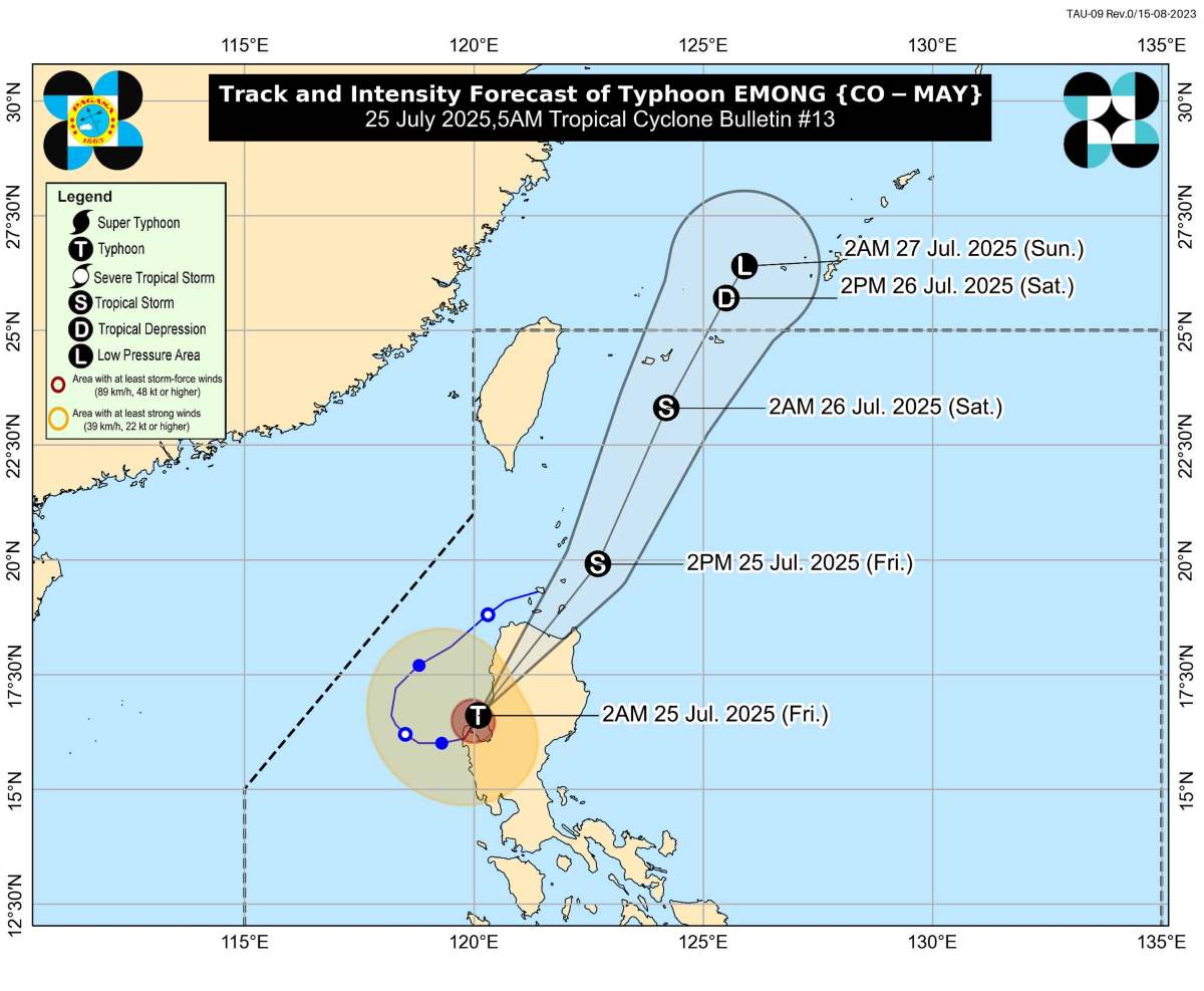
The storm is expected to continue approaching or passing through Babuyan Islands at noon this afternoon, then likely approach the Batanes Islands in the evening. During this process, Emong can maintain the intensity before gradually weakening due to terrain friction.
A high wave and high tide warning has been activated across the waters north of and west of Luzon. According to PAGASA, storm surge could reach 14 meters in the western part of Ilocos Sur, La Union and Pangasinan.
Philippine authorities have urgently evacuated people in dangerous areas, and warned of the possibility of flash floods, landslides and prolonged power outages in many mountainous areas.
While Emong is roaming in Luzon, two other storms are also gathering in the Northwest Pacific - a storm near the East Sea, threatening to form a complex chain of tropical cyclones in the coming days.
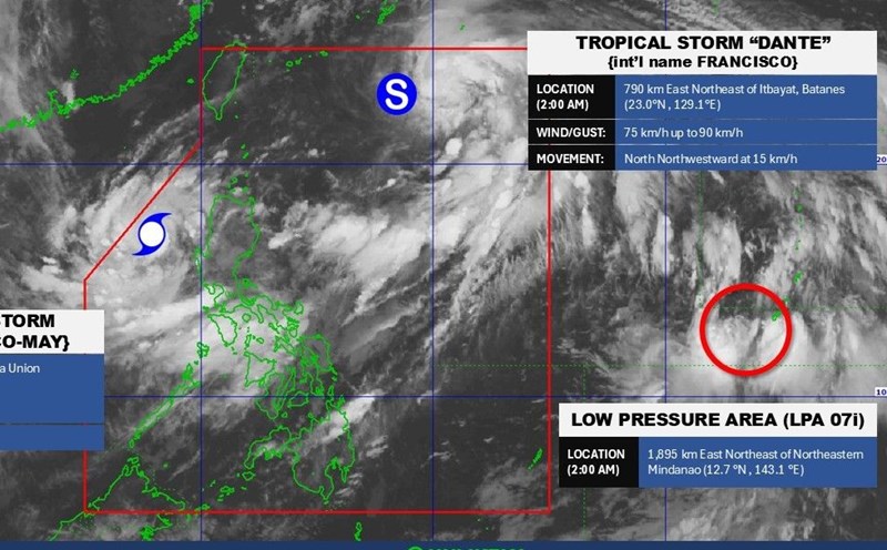
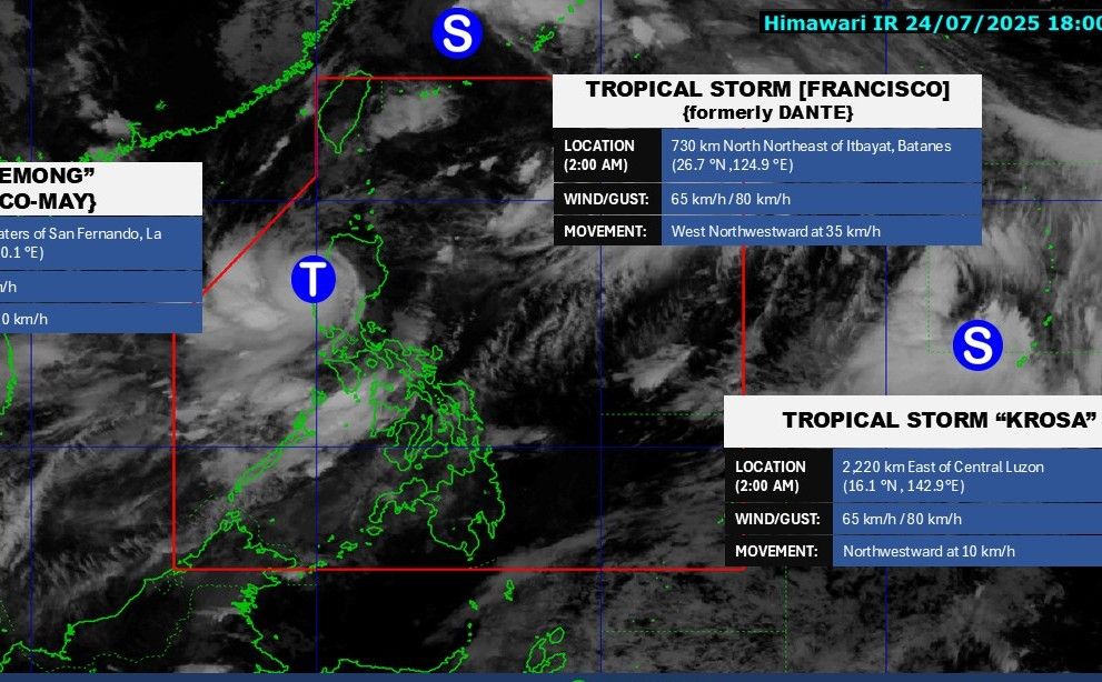
Typhoon Franscisco (local name: Dante) is still active outside the Philippines' forecast area. At 3:00 a.m. on July 25, the center of San Francisco was at 26.9 degrees north latitude, 124.7 degrees east longitude, 740 km east-northeast of Itbayat, Batanes. Maximum winds near the center of the storm are 65 km/h, gusting to 80 km/h. The storm is moving west-northwest at a speed of 35 km/h.
Meanwhile, Typhoon Krosa continues to strengthen, with winds of 65 km/h, gusts of 80 km/h, at 16.1 degrees north latitude, 142.9 degrees east longitude, 2,030 km east of southeast Luzon. The storm is moving northwest at a speed of 10 km/h.
Experts warn that with the sea temperature being unusually high in July - the main month of the storm season, the risk of the formation of "orderly storm lumps" in the Northwest Pacific and the East Sea is entirely possible.
The Vietnam National Center for Hydro-Meteorological Forecasting said that although storm No. 4 Comay did not make landfall in Vietnam, today (July 25), the eastern sea of the North East Sea will have strong winds of level 7-8, the area near the storm's eye will have strong winds of level 9-10, gusts of level 12; waves 4-6m high. The sea is very rough.
Ship operating in the above-mentioned dangerous areas are likely to be affected by thunderstorms, whirlwinds, strong winds, and large waves.