The latest storm information from the Philippine Atmospheric, Geophysical and Astronomical Services Administration (PAGASA) said that at 4:00 a.m. on July 17, the center of tropical depression Crising was at about 13.1 degrees north latitude, 128.9 degrees east longitude, about 535km east of Juban, Sorsogon, Philippines.
The tropical depression is moving west-northwest at a speed of 15 km/h, carrying maximum sustained winds of 55 km/h and gusts of up to 70 km/h.
Crising is forecast to continue to strengthen over the next 48 hours and could reach tropical storm strength on July 18. On its way across the Philippine Sea, Crising is likely to become a strong tropical storm, reaching severe tropical storm status in the afternoon or evening of July 19 before approaching the mainland of Northern Luzon.
PAGASA said that the current scenario is that Crising can approach or make landfall directly in Cagayan province or Babuyan Islands from the night of July 19 to the early morning of July 20. The storm will then continue to move west-northwest, crossing the northern part of Luzon Island and may exit the Philippine Forecast Area (PAR) late on or early on July 20.
Faced with the risk of strong winds, heavy rains and flash floods accompanied by landslides, PAGASA recommends that people in vulnerable areas proactively evacuate when requested by local authorities and closely monitor the latest weather forecasts.
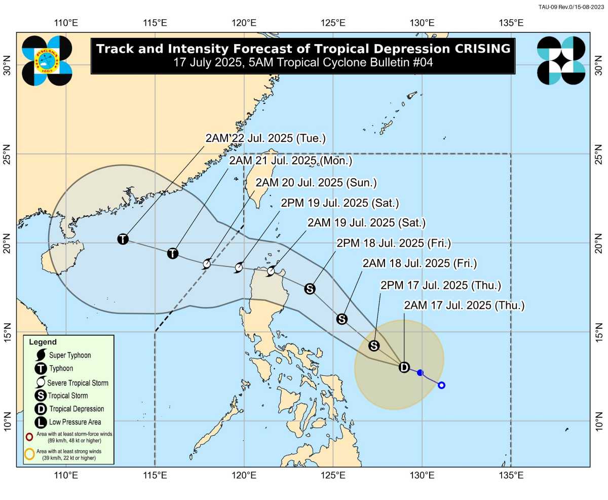
Meanwhile, the storm forecast bulletin at 2:00 a.m. on July 17 of the Vietnam National Center for Hydro-Meteorological Forecasting also said that the tropical depression near the East Sea will have gusts of level 9, moving west-northwest, at a speed of about 20km/h.
It is forecasted that by 1:00 a.m. on July 18, the tropical depression will move west-northwest, at a speed of about 20km/h.
Location: 16.2 degrees north latitude, 124.5 degrees east longitude, in the sea east of Luzon Island, Philippines.
Intensity: Level 8, gust level 10, likely to strengthen into a storm
At 1:00 a.m. on July 19: Continue moving northwest, speed 20-25 km/h.
Location: 18.9 degrees north latitude, 119.8 degrees east longitude, in the eastern sea of the North East Sea, becoming storm No. 3. Intensity: Level 10, gust level 12.
Dangerous areas in the East Sea ( strong winds of level 6 or higher): From 16.5 to 21.0 degrees north latitude, from 117.5 to 120.0 degrees east longitude.
Sea disaster risk level: Level 3 (eastern sea area of the North East Sea)
Warning from the next 48-72 hours: The storm will continue to move west-northwest, traveling 15-20km per hour and is likely to continue to strengthen.