Forecast of the most affected area of a potential storm right after storm No. 3

Khánh Minh |

Following Typhoon No. 3 Wipha, the next storm - Typhoon Dante is expected to form today (July 23,) near the Philippines.

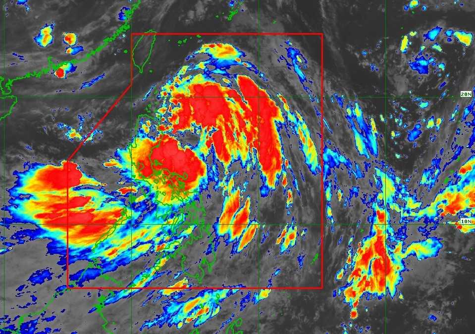
The latest typhoon news of the Philippine Department of Astronomy, Geophysics and atmosphere (Pagasa) on the morning of July said that the tropical depression Dante remained strength when moving fast in the Northwest in the Philippines, which significantly affects the weather on the mainland even though it is far from the northernmost region of Luzon Island to 880km.

According to Pagasa, at 4am on 23.7, the tropical depression Dante was determined at 20.1 degrees North latitude, 130.4 degrees of eastern menstrual degrees, with the strongest wind near the center of 55 km/h, 70 km/h.

The tropical downstream Dante is moving northwest at 25 km/h and is expected to be stronger into a storm within the next 12 hours, towards the Ryukyu Islands (Japan) and the East China Sea. Although the possibility of stronger storms is not high, it still cannot be excluded.

Ap thap nhiet doi Dante du kien manh len thanh bao vao chieu 23.7. Anh: PAGASA
Tropical depression is expected to strengthen the storm on the afternoon of July 23. Photo: Pagasa

The worrying thing is that Dante is intensifying the activity of the southwest monsoon, which has caused persistent rain for many days in Luzon's regions. PAGASA warned that during the day and tonight, the southwest monsoon will continue to bring heavy to very heavy rain, even in some places with extremely heavy rain in densely populated areas, including:

High-risk areas of heavy rain and flooding: Metro Manila (capital area), Benguet, Pangasinan, tarlac, Pampanga, Bulacan, Zambales, Bataan, Cavite, Laguna, Batangas, Rizal, Occidental Mindoro.

likely areas with scattered showers: MIMAROPA (including Palawan), La Union, Nueva Ecija, Quezon, Camarines Sur, Catanduanes, Albay, Sorsogon, Masbate, Antique, Iloilo, Guimaras, Negros Occidental.

Not only the rain, strong winds are also spreading due to the combined influence of Dante and the Southwest monsoon. It is forecasted that in the next 3 days (September 26-25) strong winds of level 6-7, some places with gusts of level 8-9 will affect a series of coastal areas, hills and plateau in the Philippines.

PAGASA recommends that fishermen and small fishing vessels should not set sail in many sea areas in the next 24 hours due to waves 2-3.5 m high. Dangerous areas include:

Waves up to 3.5m high: West of Lubang Island.

Waves 3m or more: Batanes, Kalayaan, Zambales coast, Bataan, Western Mindoro, Calamian.

Waves 2-2.5m: Many coastal areas of Northern Luzon, Bicol and the Visayas.

Not only Dante, there are currently 2 other tropical depressions being closely monitored. One of them - the 7am low pressure - has been assessed by PAGASA as having a "high probability" of becoming a storm within the next 24 hours.

Another system - low pressure 07i - outside the Philippines is also likely to enter and strengthen in the coming days.

3 he thong bao/ap thap bua vay Philippines. Anh: PAGASA
3 systems of storms/low pressure surrounding the Philippines. Photo: PAGASA

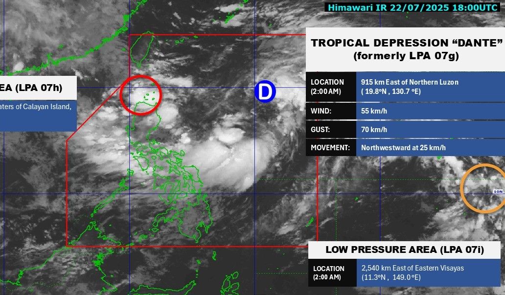
If the weather developments are as forecast, the Philippines could face up to 3 dangerous weather systems in less than 48 hours.

Meanwhile, storm No. 3 Wipha (storm Crising named after the Philippines) last night (July 22), weakened into a low pressure area over the Vietnam - Laos border, according to the weather forecast at 1:00 a.m. on July 23 of the Vietnam National Center for Hydro-Meteorological Forecasting.

Bao so 3 suy yeu thanh ap thap. Anh: Trung tam Du bao Khi tuong Thuy van Quoc gia Viet Nam
Storm No. 3 weakens into a low pressure area. Photo: Vietnam National Center for Hydro-Meteorological Forecasting

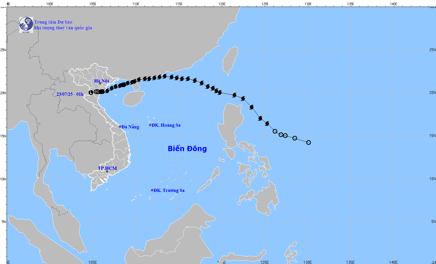
At 1:00 a.m. on July 23, the low pressure area was located at about 20.0 degrees North latitude; 104.8 degrees East longitude. The strongest wind in the center of the low pressure area is below level 6 (under 39 km/h).

It is forecasted that in the next 12 hours, the low pressure area will continue to move mainly in the West Southwest direction, weakening and gradually dissipating.

Khánh Minh
TIN LIÊN QUAN

China activates emergency response to prevent flooding caused by storm No. 3 Wipha

|

Typhoon Wipha made landfall twice in China. On July 21, eastern China activated an emergency response to prevent flooding caused by the storm.

Low pressure appears near the East Sea as storm Wipha is moving into the Gulf of Tonkin

|

The low pressure near the East Sea appeared from the night of July 20 in the context of Typhoon Wipha active in the East Sea.

Typhoon Wipha forecast to strengthen over the Gulf of Tonkin, making landfall in Vietnam today

|

After making landfall in China, Typhoon Wipha is moving into the Gulf of Tonkin and is forecast to make landfall in Vietnam today (July 21).

Designer Nguyen Cong Tri's career before being arrested for drug-related crimes

|

Before being arrested for drug-related crimes, Nguyen Cong Tri was considered one of the most successful Vietnamese designers in both domestic and international markets.

Deeply flooded in Nghe An, Medical Center urgently evacuated 140 patients by boat

|

Nghe An - The district health center was deeply flooded, forcing 140 patients and their families to be urgently evacuated by boat to safety.

Thu Duc market kiosk fire, firefighters promptly extinguished

|

HCMC - A kiosk selling soft drinks at Thu Duc Market caught fire. Fire Prevention and Rescue Police quickly arrived, extinguishing the fire, avoiding major damage.

Two tractor-trailers collide, causing one to catch fire, the driver to be seriously injured

|

Ha Tinh - After a collision on the way to Cau Treo International Border Gate, a Lao-seat tractor caught fire, a Nghe An-seat vehicle was severely damaged, and the driver was injured.

More than 18,000 illegal slaughterhouses increase the risk of African swine fever outbreak

|

The Deputy Minister of Agriculture and Rural Development emphasized the need to resolutely handle slaughterhouses that do not ensure food hygiene and safety - one of the causes of the spread of African swine fever.

China activates emergency response to prevent flooding caused by storm No. 3 Wipha

Thanh Hà |

Typhoon Wipha made landfall twice in China. On July 21, eastern China activated an emergency response to prevent flooding caused by the storm.

Low pressure appears near the East Sea as storm Wipha is moving into the Gulf of Tonkin

Thanh Hà |

The low pressure near the East Sea appeared from the night of July 20 in the context of Typhoon Wipha active in the East Sea.

Typhoon Wipha forecast to strengthen over the Gulf of Tonkin, making landfall in Vietnam today

Thanh Hà |

After making landfall in China, Typhoon Wipha is moving into the Gulf of Tonkin and is forecast to make landfall in Vietnam today (July 21).