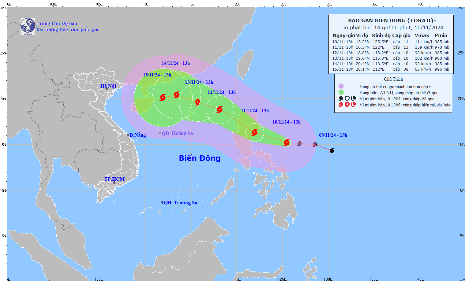
The latest storm news at 2:00 p.m. on November 10 from the Philippine Atmospheric, Geophysical and Astronomical Services Administration (PAGASA) said that the center of storm Toraji (called Nika in the Philippines) was at about 15.1 degrees north latitude, 125.6 degrees east longitude, 425km east of Infanta, Quezon, Philippines.
The storm is continuing to strengthen, with winds near the center of the storm of 110 km/h (up from 100 km/h at 4:00 a.m. on November 10), gusts up to 135 km/h (up from 125 km/h), barometric pressure of 980 hPa (down from 985 hPa), and storm cloud radius of 340 km (up from 300 km).
The storm is moving west at 30 km/h.
Nika is on track to become a typhoon on November 10, then reach its peak intensity before making landfall. According to PAGASA's classification, a typhoon is a storm with maximum sustained winds of 118 to 184 km/h.
This storm is also considered to be very strong, with a twisted cloud structure and the possibility of forming a storm eye cannot be ruled out.
Nika is forecast to make landfall in Isabela or Aurora on or early Monday afternoon, November 11. It will then move across mainland Luzon, where it is expected to “briefly weaken,” and into the South China Sea as a Category 8 storm by the evening of November 11, where it could re-strengthen.
Based on PAGASA’s latest rainfall advisory as of 2 p.m. on November 10, Aurora and Isabela provinces are expected to experience heavy to very heavy rains in the next 24 hours.

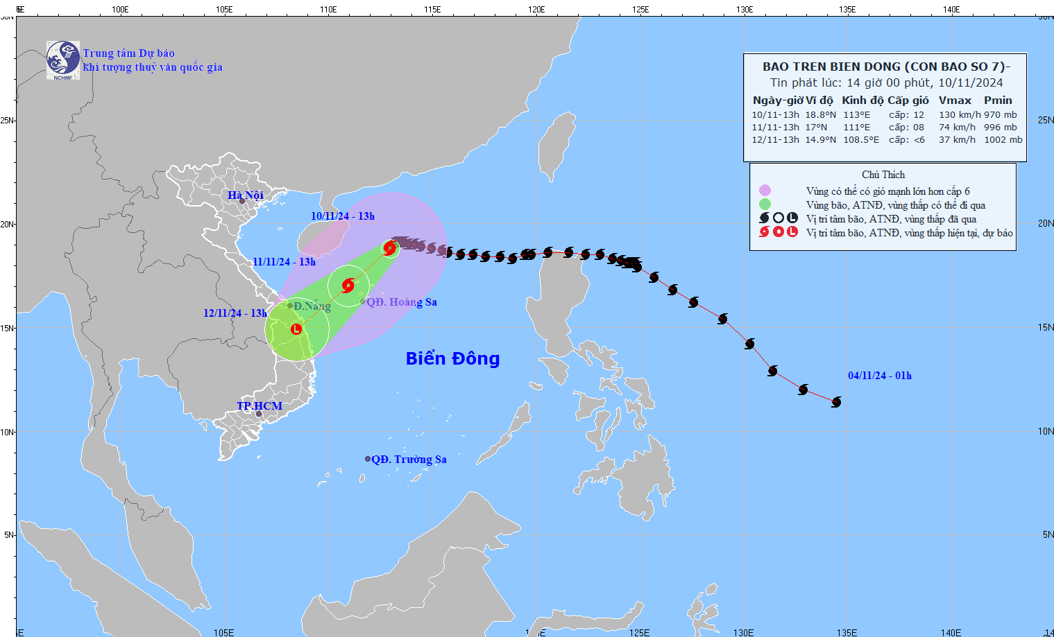
Meanwhile, at 1:00 p.m. on November 10, the center of storm No. 7 Yinxing was at about 18.8 degrees north latitude; 113.0 degrees east longitude, in the western sea area of the northern East Sea, about 240 km north-northeast of Vietnam's Hoang Sa archipelago. The strongest wind near the center of the storm reached level 12 (118-133 km/h), gusting to level 14. The storm moved southwest at a speed of about 5 km/h.
According to the Vietnam National Center for Hydro-Meteorological Forecasting, storm No. 7 is moving into an area with unfavorable environmental conditions for storm development; because the current sea surface temperature in the western area of the Hoang Sa region is below the optimal level, below 26 degrees Celsius, reducing the energy supply for the storm, contributing to its gradual weakening.

It is forecasted that within the next 24-48 hours, storm No. 7 is expected to continue moving southwest and its intensity will rapidly decrease to below level 10.
It is forecasted that on the morning of November 11, when moving into the eastern area of Luzon Island of the Philippines, the distance between storm No. 7 (Yinxing) and storm Toraji will be about 1,200-1,400 km, which is the distance where the double storm interaction occurs, storm Toraji will cause storm No. 7 (Yinxing) to deviate more to the south.
Under the impact of these two storms, the northern and central regions of the East Sea will continuously experience bad weather in the coming days, with strong winds, high waves and rough seas.


