The storm forecast bulletin of the Philippine Atmospheric, Geophysical and Astronomical Services Administration (PAGASA) said that at 4:00 a.m. on November 8, the center of Typhoon Yinxing (called Marce by the Philippines) was at about 18.5 degrees north latitude; 119.8 degrees east longitude, in the western sea of Ilocos Norte, east of the northern part of the West Philippine Sea (South China Sea).
PAGASA said that although the storm weakened slightly overnight, the strongest wind near the center of the storm was still at level 14 (155 km/h) near the center of the storm, gusting up to 215 km/h (level 17.7) and the central pressure was 955 hPa.
Typhoon Yinxing made landfall twice in northern Luzon on November 7. The first landfall occurred at 3:30 p.m. in Santa Ana with a maximum intensity of 233 km/h, with a pressure of 937 mbar. The second landfall came a few hours later near Claveria at the same level. The Babuyan Islands in the north were also devastated by this powerful eye wall.
Typhoon Yinxing is moving west-northwest at a speed of 10 km/h. Strong winds extend up to 500 km from the center of the storm.
PAGASA will continue to issue a strong wind warning of level 12 (118 to 184 km/h) for the next 12 hours in some areas of Luzon such as the northernmost part of Ilocos Sur, the northern part of Abra (Danglas, Lagayan, Tineg), the northwest part of Apayao (Calanasan) and the northwest part of the Cagayan continental.
In addition, the northeast wind and peripheral areas of Typhoon Yinxing will also bring strong to strong gusts in coastal areas and highlands exposed to the wind.
Rough seas with waves up to 12 m high on the coasts of Babuyan Islands and Ilocos Norte. 8m waves on the coast of Ilocos Sur. 6m waves in the remaining coast of Ilocos Region; the west coast of Batanes.
Typhoon Yinxing is forecast to continue moving westward and exit the Philippine Forecast Area (PAR) this afternoon or evening (November 8).
Meanwhile, according to the latest storm information from the Vietnam National Center for Hydro-Meteorological Forecasting, at 4:00 a.m. on November 9, the center of storm No. 7 Yinxing was at about 18.5 degrees north latitude, 116.1 degrees east longitude; in the North East Sea, about 540km northeast of Hoang Sa archipelago. Storm intensity level 13-14, gust level 17. The eastern part of the North East Sea is at risk of level 4 natural disasters.
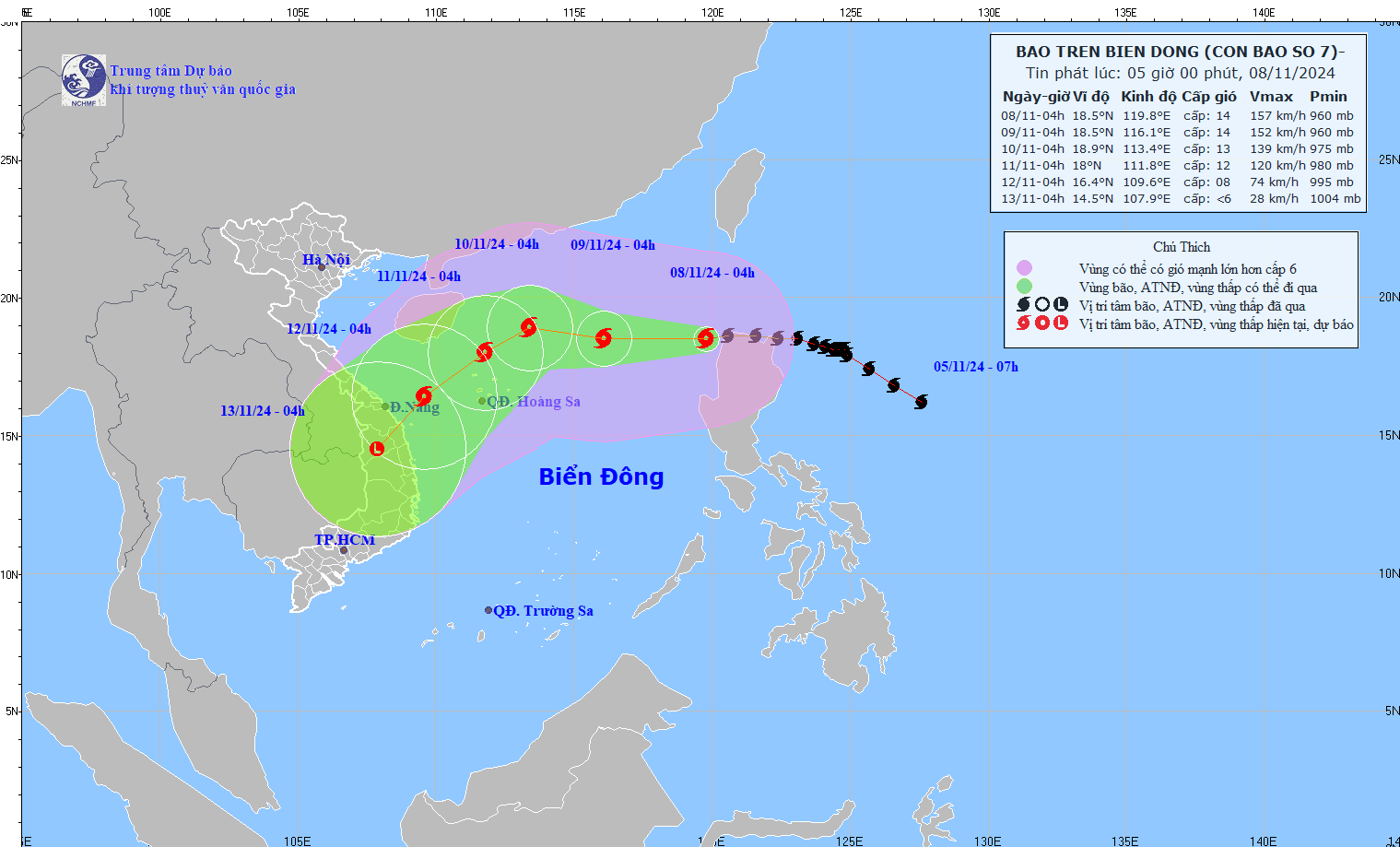
It is forecasted that by 4:00 a.m. on November 10, the center of storm No. 7 will be at about 18.9 degrees north latitude, 113.4 degrees east longitude; about 330km north-northeast of Hoang Sa archipelago. Storm intensity level 12-13, gust level 16. The northern East Sea area (including the Hoang Sa archipelago) is at risk of level 3 natural disasters.
From the next 72 to 120 hours, storm No. 7 in the East Sea will move southwest, traveling 10-15km per hour, and will continue to weaken.


