The storm and low pressure forecast for February 3 by the Philippine Atmospheric, Geophysical and Astronomical Services Administration (PAGASA) stated that during the week from February 3 to February 9, a new low pressure is expected to form near the Philippines.
A new low pressure area is likely to develop south of PAGASA's PAR forecast area.
According to forecasters, this low pressure is located in the sea near the Philippines and is likely to enter the East Sea.
The first low pressure of 2025 has little chance of strengthening into a storm.
Right after the first low of 2025, a second low is expected to form east of the Philippines during the week of February 10-16.
It is forecasted that this low pressure near the East Sea will form in the southern area of PAR and gradually move westward before entering the East Sea.
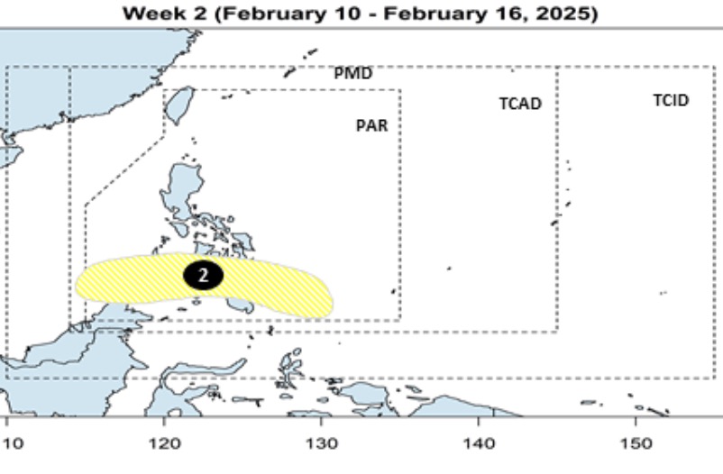
Philippine weather forecasters said the second low pressure system is unlikely to strengthen into a storm during the forecast period.
Last week, PAGASA said no low pressure areas had been recorded forming within or outside the PAR forecast area as of February 1. At the time, PAGASA weather expert Grace Castaneda shared: "This February, there is a possibility of zero or only one tropical storm forming or entering the Philippine forecast area."
She added that PAGASA's monthly weather forecast said that if it forms, the storm is likely to approach eastern Visayas and Mindanao.
If the storm forms and enters the forecast area of the Philippines, it will be locally named “Auring”. This is the first storm name in the list of storm names for the 2025 typhoon season in the Philippines set by PAGASA.