Low pressure forecast near the East Sea has a 70% chance of strengthening into a storm

Khánh Minh |

A low pressure area near the East Sea that appeared on May 2 has a 70% chance of strengthening into a storm in the next 7 days.

At 3:00 a.m. on May 2, a new low pressure area named LPA 5a was located by the Philippine Atmospheric, Geophysical and Astronomical Services Administration (PAGASA) about 440 km east of Hinatuan, Surigao del Sur. The center of the low pressure is located at about 8.8 degrees north latitude, 130.3 degrees east longitude.

The depression is located along the tropical convergence zone - an area that is prone to rain - affecting Mindanao. Meanwhile, the southeast wind is dominating the weather in the rest of the country.

PAGASA's weather forecast says the low pressure near the South China Sea is likely to cause widespread rain in the Bicol, Visayas and Mindanao regions.

PAGASA also forecasts that the low pressure will bring showers to Central Visayas, Eastern Visayas, Northern Mindanao, Davao and Caraga regions. These rains can range from moderate to heavy, posing a potential risk of flooding and landslides.

The rest of Visayas and Mindanao will continue to be affected by the tropical convergence zone, causing scattered showers.

Meanwhile, Metro Manila and the rest of Luzon are expected to see little to no clouds, hot and hot weather. Under the influence of the winter wind, the possibility of local showers and thunderstorms during the day is quite high.

According to PAGASA's latest storm forecast, the possibility of the low pressure developing into a storm in the next 24 hours is low. However, the low pressure tends to move closer to the mainland and may cross the Visayas region to move west of Palawan in the coming days.

Although the depression is active, PAGASA has not issued a strong wind warning over the Philippine waters. The overall sea waves are forecast to be mild to moderate, with waves ranging from 0.6 to 1.8 meters high.

Meanwhile, the US Joint Typhoon Warning Center (JTWC) named the low pressure area near the East Sea as 90W. The JTWC forecasts that the low pressure may strengthen into a tropical depression by the end of this week.

Anh: JTWC
JTWC forecasts that low pressure 90W has a 70% chance of strengthening into a storm in the next 7 days. Photo: JTWC

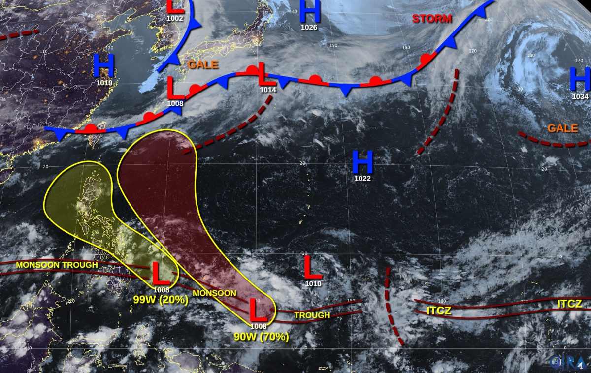
With a pressure of 1008 hPa, the low pressure is creating scattered convective clouds. The low pressure's circulation is gradually becoming more apparent. With favorable upper-level wind conditions, the high pressure is likely to develop into a tropical depression as it moves northwest, entering the central Philippine Sea.

The JTWC assessed the possibility of the low pressure strengthening into a storm in the next 7 days at a high level, up to 70%.

Previously, the latest typhoon news on May 1 from PAGASA said that there are forecasts of 1 to 2 typhoons forming in the Philippine Forecast Area (PAR) in May.

Khánh Minh
RELATED NEWS

New low pressure appears soon, forecast to have 2 storms near the East Sea in May

|

The latest storm forecast from the Philippine Atmospheric, Geophysical and Astronomical Services Administration (PAGASA) predicts two storms near the East Sea in May.

double risk as 2 consecutive low pressure areas threaten to approach the East Sea

|

The two low pressure areas are likely to approach the East Sea at the same time, causing double risks.

Low pressure appears near the Philippines, risk of strengthening on April 30

|

According to the storm/low pressure forecast on April 26, low pressure 99W forming near the Philippines is at risk of strengthening early next week.

Live football Arsenal vs Bournemouth in Premier League

|

The match between Arsenal and Bournemouth takes place at 6:30 p.m. on April 11 (Vietnam time).

Update on gasoline and oil prices on April 11: World oil prices reverse sharply

|

Update on gasoline and oil prices on April 11: In today's trading session, world oil prices reversed to decrease.

Live Nam Dinh vs Hoang Anh Gia Lai in round 18 of V.League 2025-2026

|

Live football match between Nam Dinh and Hoang Anh Gia Lai in round 18 of V.League 2025-2026 at 6:00 p.m. today (April 11).

Ring Road 2.5, Dich Vong - Duong Dinh Nghe section is expected to open to traffic in September

|

Hanoi - Ring Road 2.5, Dich Vong - Duong Dinh Nghe section is expected to be technically opened to traffic in early September if the site is handed over on schedule.

Explaining why the 72 billion VND irrigation project has not been handed over after many pipe bursts

|

Dak Lak - The Provincial Department of Agriculture and Environment has explained the reason for not being able to hand over the 72 billion VND irrigation project after many pipe bursts.

New low pressure appears soon, forecast to have 2 storms near the East Sea in May

Thanh Hà |

The latest storm forecast from the Philippine Atmospheric, Geophysical and Astronomical Services Administration (PAGASA) predicts two storms near the East Sea in May.

double risk as 2 consecutive low pressure areas threaten to approach the East Sea

Khánh Minh |

The two low pressure areas are likely to approach the East Sea at the same time, causing double risks.

Low pressure appears near the Philippines, risk of strengthening on April 30

Khánh Minh |

According to the storm/low pressure forecast on April 26, low pressure 99W forming near the Philippines is at risk of strengthening early next week.