The latest storm and low pressure information on April 30 from the Philippine Atmospheric, Geophysical and Astronomical Services Administration (PAGASA) said that the low pressure is likely to strengthen into a storm in the first half of May.
Philippine typhoon forecasters said that models indicate that during the week of April 30 to May 6, two low pressure areas near the East Sea are forecast to form in a row in the PAGASA PMD forecast area.
The first low pressure is likely to form in the southern part of the Philippine Forecast Area (PAR). The low pressure is expected to strengthen into a low to moderate storm.
Regarding the direction of the low pressure near the East Sea that has the potential to strengthen into a storm, PAGASA pointed out that this system tends to move east of Mindanao, Visayas and Southern Luzon, Philippines during the forecast period.
Also during the week of April 30 to May 6, the second low pressure near the East Sea is expected to form in the southeastern boundary of PAGASA's TCAD forecast area.
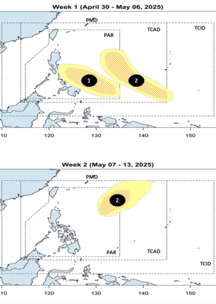
This second low pressure is expected to enter the Philippine PAR forecast area. Similar to the first low pressure, the second low pressure is also likely to strengthen into a low to moderate storm.
Philippine weather forecasters said that during the week of May 7 to May 13, the second low pressure forecast near the East Sea formed last week is likely to strengthen into a storm and continue to cause impacts. This storm is likely to have a major impact in the Philippine Sea.
In the development related to storms and low pressure near the East Sea, on the afternoon of April 30, PAGASA said that at 2:00 p.m. the same day, low pressure LPA 04a appeared since the beginning of this week and had disappeared. Currently, Philippine forecasters are not monitoring any low pressure areas that could strengthen into storms.
The Philippines is likely to be affected by storms in the western Pacific basin due to its geographical location. Storms often cause heavy rain, flooding and strong winds in many areas of the country.
More typhoons have entered the Philippine PAR forecast area than anywhere else in the world, according to PAGASA.
An average of 20 tropical storms form or enter the PAR each year, of which about 8 or 9 make landfall in the Philippines.
The typhoon season in the Philippines peaked from July to October, with nearly 70% of the season's storms appearing during this period.
When active in the Philippine forecast area, the first storm of the year will be locally named Auring - the first name on PAGASA's list of typhoon names for the 2025 typhoon season.