The latest storm information from the Philippine Atmospheric, Geophysical and Astronomical Services Administration (PAGASA) said that at 2:00 a.m. on May 28, the low pressure was active in the West Philippine Sea ( East Sea), near the Pagasa archipelago in Palawan province, Philippines.
Although not within the Philippine Forecast Area (PAR), this low pressure has caused cloudy weather, scattered showers and thunderstorms in the Zamboanga, Western Visayas, Negros, Basilan, Sulu, Tawi-Tawi, Palawan, Western Mindoro, Oriental Mindoro and Romblon islands.
PAGASA weather forecaster Benison Estareja said: This low pressure area is unlikely to enter PAR and develop into a tropical depression. It is likely to subside over the next few days.
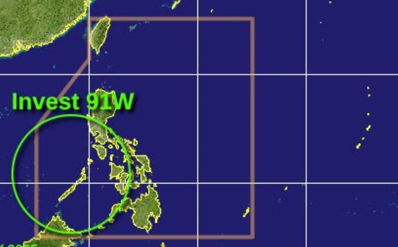
Meanwhile, the Joint Typhoon Warning Center (JTWC) named the low pressure area off the east coast of Vietnam Invest 91W. According to the JTWC, the depression is developing with increasingly clear thunderstorm clusters, although the center of the tornado has not yet been clearly defined.
Current environmental conditions are only average for the formation of a tropical cyclone. However, there is a high possibility of a short-term tropical depression, even a small storm, forming over the weekend as the system moves north, then turns northeast towards the Luzon Strait - the sea between the northern Philippines and Taiwan (China).
From the end of the week, the low pressure will begin to interact with the Front Meiyu/Tsuyu cloud band causing rain - a summer weather system that mainly causes rain in the eastern and southern regions of China and Japan - causing the development ability to continue to decline.
The possibility of tropical cyclone formation in the next 7 days is 60%.
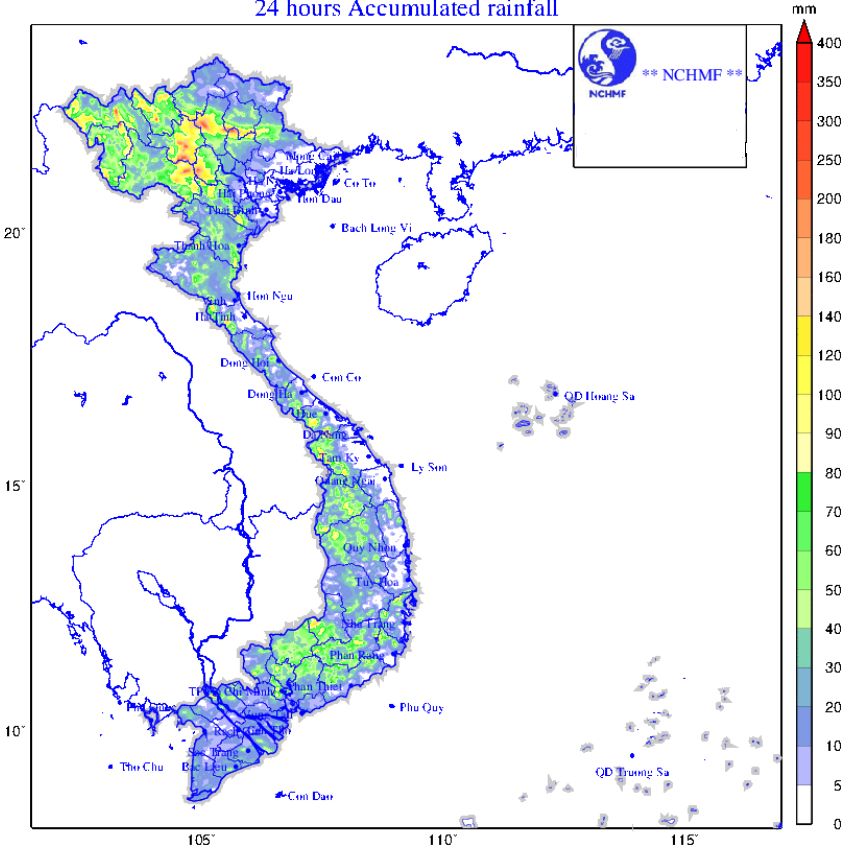
Meanwhile, according to the Vietnam National Center for Hydro-Meteorological Forecasting, on the day and night of May 28, in the Gulf of Tonkin, the sea area from Binh Dinh to Ca Mau, Ca Mau to Kien Giang and the Gulf of Thailand, the North East Sea (including Hoang Sa archipelago), the central and southern East Sea (including Truong Sa archipelago) there will be scattered showers and thunderstorms.
During thunderstorms, there is a possibility of tornadoes, strong gusts of wind of level 6-7, waves over 2m high.
Regarding rain forecast, from the evening of May 28 to the night of May 29: The North is forecast to have common rainfall of 40-100mm. Locally over 200mm.
From the night of May 29 to the morning of May 30: The North Central region is forecast to have 30-60mm of common rain. locally over 100mm.
From the afternoon of May 28 to May 29: The Central Highlands and the South are forecast to have common rainfall of 30-60mm. locally over 100mm.
Risk of local heavy rain over 100mm/3 hours.
In the late afternoon and evening of May 28, the South Central region will have scattered showers and thunderstorms, locally heavy rain with common rainfall from 15-30mm, some places over 60mm.
During thunderstorms, tornadoes, lightning, hail, and strong gusts of wind may occur.
From May 30, heavy rain in the above areas tends to decrease.