A second low pressure appears near the East Sea

Thanh Hà |

The second low pressure near the East Sea formed on the afternoon of July 27 near the area where super storm No. 3 Gaemi formed.

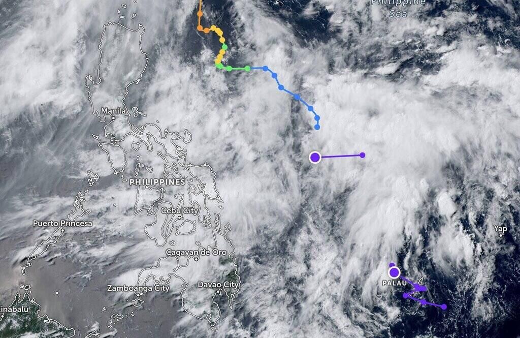
According to the latest storm and tropical depression information from the Joint Typhoon Warning Center (JTWC) of the US Navy and US Air Force, a low pressure near the East Sea formed on the afternoon of July 27 in the Philippine Sea. It is forecasted that this low pressure has little chance of strengthening into a tropical storm in the next 24 hours.

The newly discovered low pressure near the East Sea, called Invest 96W by the Joint Typhoon Warning Center, has maximum sustained winds of about 30 km/h (15 knots). The estimated minimum sea level pressure is nearly 1008 hPa. A new low pressure near the East Sea was discovered not far from the location where super storm No. 3 Gaemi formed.

Meanwhile, the area near the East Sea has had a low pressure forming since the afternoon of July 25, according to the Philippine weather agency PAGASA.321

PAGASA's latest storm and tropical depression news said that this depression is about 770 km east of Butuan city, Agusan del Norte in the Philippines.

PAGASA storm forecaster Chenel Dominguez told Inquirer: "This low pressure is still at sea, so we cannot rule out the possibility that this low pressure will strengthen into a storm ."

Two low pressure near the East Sea (purple) are continuing to strengthen, of which the low pressure that just formed on the afternoon of July 27 is located near the path of super storm No. 3 Gaemi (blue). Photo: Zoom Earth

Due to the trough or extension of low pressure near the South China Sea , cloudy weather, scattered rain and thunderstorms are forecast in the Bicol area, Eastern Visayas, Northern Mindanao, Surigao del Norte, Surigao del Sur, Dinagat Islands and Quezon of the Philippines. There are currently no gust warnings in effect for any Philippine waters.

The Joint Typhoon Warning Center (JTWC) calls this depression Invest 95W, located south of Invest 96W. According to the latest storm forecast, this depression is unlikely to strengthen into a tropical storm in the next 24 hours. Storm forecast models also found no significant strengthening of low pressure Invest 95W.

According to PAGASA, in addition to two low pressure near the East Sea, the weather in the Philippines is strongly influenced by the southwest monsoon, or hagabat. The southwest monsoon continues to cause scattered rain and storms in many areas of the country.

PAGASA's latest weather forecast states that cloudy to partly cloudy skies are expected with scattered showers and thunderstorms in Metro Manila, Western Visayas, Cavite, Laguna, Batangas, Western Mindoro and Palawan.

Thanh Hà
TIN LIÊN QUAN

Cơn bão mới nhất ở Đại Tây Dương đang manh nha hình thành

Thanh Hà |

Tin bão mới nhất cho hay, Trung tâm Bão quốc gia Mỹ đang theo dõi một vùng áp thấp ở Đại Tây Dương có khả năng mạnh lên thành bão.

Áp thấp gần Biển Đông gây những ảnh hưởng đầu tiên

Thanh Hà |

Áp thấp gần Biển Đông, gió mùa tây nam và giông bão cục bộ khiến trời nhiều mây, mưa kéo dài ở khắp Philippines trong ngày 27.7.

Phát hiện áp thấp mới gần Biển Đông

Thanh Hà |

Áp thấp gần Biển Đông được phát hiện ở miền nam Mindanao, Philippines ngay khi siêu bão Gaemi rời khu vực dự báo của nước này.

Tin 20h: Yên Bái kiểm tra nhà hàng "chặt chém" đoàn từ thiện

Nhóm PV |

Tin 20h ngày 19.9: Bà Nguyễn Phương Hằng được ra tù vào hôm nay; Yên Bái kiểm tra nhà hàng bị tố chặt chém đoàn từ thiện...

Phía Miss Universe nói về thông tin Kỳ Duyên chưa tốt nghiệp

Huyền Chi |

Thông tin Hoa hậu Kỳ Duyên chưa tốt nghiệp Trường Đại học Ngoại Thương gây xôn xao mạng xã hội.

Trực tiếp bóng chuyền U23 Thể Công Tân Cảng 1-0 U23 Ninh Bình: Set 2

Nhóm PV |

Trực tiếp chung kết giải bóng chuyền U23 quốc gia giữa U23 Thể Công Tân Cảng vs U23 Ninh Bình vào lúc 20h ngày 19.9.

Chậu hoa giấy trên phố đi bộ ở Đà Nẵng đồng loạt "nằm" tránh bão

Nguyễn Linh |

UBND quận Hải Châu, TP Đà Nẵng cho biết đã chủ động đặt nằm các chậu hoa giấy tại phố đi bộ Bạch Đằng để tránh thiệt hại bởi ảnh hưởng của cơn bão số 4.

Cháy lớn Hà Nội, khói lửa cuồn cuộn khiến người dân khiếp sợ

Hải Danh |

Một xưởng in rộng khoảng 400m2, kết cấu khung thép, mái tôn trên địa bàn quận Nam Từ Liêm (TP Hà Nội) bốc cháy dữ dội khiến người dân khiếp sợ.

The latest storm in the Atlantic is starting to form

Thanh Hà |

The latest storm news says that the US National Hurricane Center is monitoring a low pressure area in the Atlantic Ocean that is likely to strengthen into a storm.

Low pressure near the East Sea causes the first effects

Thanh Hà |

Low pressure near the East Sea , southwest monsoon and local thunderstorms caused cloudy weather and prolonged rain across the Philippines on July 27.

New low pressure detected near the East Sea

Thanh Hà |

Low pressure near the East Sea was detected in southern Mindanao, Philippines as soon as super typhoon Gaemi left the country's forecast area.