As soon as news broke that super typhoon Yagi was expected to make landfall in Quang Ninh, an electronics store owner in Ha Long announced that he would rent two tiger trucks or two container trucks to park in front of the store to block the wind on September 6 and 7.
By the afternoon of September 6, the owner of this store had rented 2 containers and placed them at the 2 fronts of the store.
After completing the construction of the two containers, the store owner jokingly shared on his personal page that "there was no other way". Many people commented, praising the creative approach, but also a way for those who have the means to prevent storms.

Some people have suggested adding heavy objects to the container to make it more stable in storms. The store owner said he added more objects to the container to prevent it from tipping over.
Meanwhile, fearing that their car would be flooded, a resident in Ha Long put the car in a waterproof tarpaulin and hung it up by the four ends. In Ha Long, some areas are often deeply flooded during prolonged heavy rains, so the risk of flooding is inevitable during this storm Yagi.

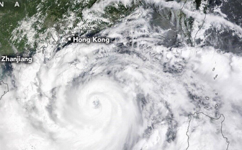
According to the National Center for Hydro-Meteorological Forecasting, at 10:00 p.m. on September 6, half of the eye of storm No. 3 had descended into the Gulf of Tonkin, with the eye of the storm at about 20.1 degrees North latitude - 109.7 degrees East longitude, about 300km from Quang Ninh.
Compared to 8:00 p.m., the storm has now decreased by 1 level from level 15 to level 14, gusting to level 17. Thus, after entering Hainan Island, the storm has decreased by 2 levels due to the reduction of convective cloud pockets at the center of the storm.
With the above level, Typhoon Yagi is no longer a super typhoon because typhoons from level 16 and above are called super typhoons, but it is still a very strong typhoon.
According to the National Center for Hydro-Meteorological Forecasting, Typhoon Yagi is forecast to cause very strong gusts of wind, especially in the Gulf of Tonkin such as Bach Long Vi and Co To island districts. The island districts will experience winds of level 12-13, gusting to level 15. This is a very strong wind level and can destroy non-solid structures, so people need to pay attention. It is forecasted that tomorrow morning, September 7, the storm will begin to move inland along the coast. The areas forecast to first experience the storm are Mong Cai, Quang Ninh, followed by coastal areas from Quang Ninh to Thanh Hoa and mainland areas.
The time of the strongest wind is forecasted from mid-morning to late afternoon tomorrow, September 7. From the night of September 6, the Northern and North Central regions will experience widespread heavy rain.
Rainfall will increase sharply tomorrow with rainfall from 150mm - 350mm, some places can reach 500mm. In the Northeast region, the rainfall will be most concentrated from tonight until the end of tomorrow, September 7. In the Northwest region, rain will start from tomorrow until September 9.
In particular, thunderstorms caused by storm No. 3 have a very wide circulation, so before entering, the storm can form convective clouds causing thunderstorms. During thunderstorms, strong gusts of wind can occur, even equal to the wind in a storm. Therefore, people should try to limit going out at this time, or if they are on the street, find a solid shelter.