According to the Khanh Hoa Provincial Hydrometeorological Station, at 1:00 p.m. on October 4, convective clouds continued to develop strongly in many areas in Khanh Hoa.
They are Van Thang, Van Ninh, Van Hung, Dai Lanh, Tu Bong, Hoa Tri, Tay Ninh Hoa, Bac Ninh Hoa, Tan Dinh, Nam Ninh Hoa, Khanh Vinh, Khanh Son, Dien Lam, Dien Dien, Suoi Dau, Lam Son...
In the next 6 hours, convective clouds are likely to expand, causing widespread showers and thunderstorms across the province.
During thunderstorms, it is necessary to be on guard against dangerous weather phenomena such as lightning, tornadoes, whirlwinds, hail, strong gusts of wind.
The meteorological agency warns of the risk of water flowing rapidly through spillways and overflow roads, and recommends that authorities, authorities and people proactively take precautions to ensure the safety of people and property.
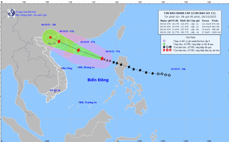
Also according to the Khanh Hoa Hydrometeorological Station, at 1:00 p.m. the same day, storm No. 11 was active in the North East Sea, about 500km East Southeast of Hainan Island (China).
The strongest wind near the storm center is level 11-12 (103-133 km/h), gusting to level 15; moving in the West Northwest direction at a speed of about 25km/h.
It is forecasted that by 1:00 p.m. on October 5, storm No. 11 will approach the eastern sea of Zhou Peninsula (China), strengthening to level 12-13, gusting to level 16. The North East Sea area has strong winds of level 8-10, near the storm center level 11-13, gusting to level 16.
The waves are 6-8m high, the sea is rough, the destructive power is huge, especially dangerous for ships and coastal works.